Country:
 Spain
SpainRegion:
City:
Latitude and Longitude:
Time Zone:
Postal Code:
IP information under different IP Channel
ip-api
Country
Region
City
ASN
Time Zone
ISP
Blacklist
Proxy
Latitude
Longitude
Postal
Route
IPinfo
Country
Region
City
ASN
Time Zone
ISP
Blacklist
Proxy
Latitude
Longitude
Postal
Route
MaxMind
Country
Region
City
ASN
Time Zone
ISP
Blacklist
Proxy
Latitude
Longitude
Postal
Route
Luminati
Country
ESRegion
an
City
cadiz
ASN
Time Zone
Europe/Madrid
ISP
Orange Espagne SA
Latitude
Longitude
Postal
db-ip
Country
Region
City
ASN
Time Zone
ISP
Blacklist
Proxy
Latitude
Longitude
Postal
Route
ipdata
Country
Region
City
ASN
Time Zone
ISP
Blacklist
Proxy
Latitude
Longitude
Postal
Route
Popular places and events near this IP address

Bay of Cádiz (comarca)
Comarca in Andalusia, Spain
Distance: Approx. 1512 meters
Latitude and longitude: 36.5271,-6.2886
The Bay of Cádiz (Spanish: Comarca de la Bahía de Cádiz) is a comarca (county, but with no administrative role) in the province of Cádiz, Andalusia, southern Spain. The present-day comarca was established in 2003 by the Government of Andalusia.

Capture of Cádiz
Battle during the Anglo-Spanish War
Distance: Approx. 1627 meters
Latitude and longitude: 36.5333,-6.28333
The capture of Cádiz in 1596 was an event during the Anglo-Spanish War, when English and Dutch troops under Robert Devereux, 2nd Earl of Essex, and a large Anglo-Dutch fleet under Charles Howard, 1st Earl of Nottingham, with support from the Dutch United Provinces, raided the Spanish city of Cádiz. Due to the Spanish commander's lack of foresight and organisation, the Anglo-Dutch forces met little resistance. In order to deny the raiders their prize, the Spanish set fire to the treasure fleet anchored in the Bay of Cádiz.
Battle of Cádiz (1656)
1656 battle
Distance: Approx. 1627 meters
Latitude and longitude: 36.5333,-6.28333
The Battle of Cádiz (1656) was an operation in the Anglo–Spanish War (1654–1660) in which an English fleet destroyed or captured the ships of a Spanish treasure fleet off Cádiz.

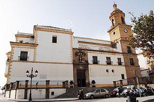
Cárcel Real (Cádiz)
Spanish neoclassical historical building
Distance: Approx. 1718 meters
Latitude and longitude: 36.5266,-6.2914
The Cárcel Real (Spanish: Royal Prison) is a historical building in Cádiz, southern Spain, an example of Neoclassical architecture.
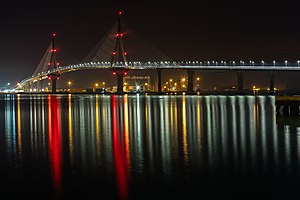
La Constitución de 1812 Bridge
Bridge in Cadiz and Puerto Real, Spain
Distance: Approx. 1538 meters
Latitude and longitude: 36.52472222,-6.25694444
The Constitution of 1812 Bridge, also known as La Pepa Bridge (El puente de la Constitución de 1812 or Puente de La Pepa in Spanish), is a new bridge across the Bay of Cadiz, linking Cadiz with Puerto Real in mainland Spain. Cadiz's first bridge, the Carranza bridge, was inaugurated in 1969, and is now crossed by some 40,000 vehicles per day. In 1982 the Spanish government accepted the need for a second bridge.

Roman Theatre (Cádiz)
Distance: Approx. 1981 meters
Latitude and longitude: 36.5283,-6.2937
The Roman Theatre of Cádiz (Theatrum Balbi) is an ancient structure in Cádiz, Andalusia, in southern Spain. The remains (only partially excavated) were discovered in 1980. The theatre, which was likely built during the 1st century BC and was one of the largest ever built in the Roman Empire, was abandoned in the 4th century and, in the 13th century, a fortress was built on its ruins by order of King Alfonso X of Castile.
Convent of Nuestra Señora del Rosario y Santo Domingo (Cádiz)
Historic site in Cádiz, Spain
Distance: Approx. 1716 meters
Latitude and longitude: 36.528757,-6.290072
The Convent of Nuestra Señora del Rosario y Santo Domingo (Spanish: Convento de Nuestra Señora del Rosario y Santo Domingo) is a convent located in Cádiz, Spain. It was declared Bien de Interés Cultural in 2005.

Arco de los Blanco
Historic site in Cádiz, Spain
Distance: Approx. 1930 meters
Latitude and longitude: 36.52833333,-6.29305556
Arco de los Blanco is an archway of the Castillo de la Villa in Cádiz, southern Spain. It has been declared a Bien de Interés Cultural site.

Cádiz Explosion
1947 explosion in Cádiz, Spain
Distance: Approx. 892 meters
Latitude and longitude: 36.5239,-6.2828
The Cádiz Explosion was a military accident which occurred at 9:45 pm, on 18 August 1947 at a storage depot in the Base de Defensas Submarinas (Submarine Defence Base) in Cádiz, Spain, when some 1,737 sea mines, torpedoes and depth charges (of a total of 2,228 distributed in two depots), containing 200 tonnes of TNT and amatol, exploded for unknown reasons. Official figures given at the time were 150 dead, a figure that has since been reduced to 147, and 5,000 injured, but other sources refer to much higher figures given the extension of the explosion and the populated districts and types of buildings destroyed. As well as the actual military facilities destroyed, the populated districts of San Severiano and San José were seriously damaged.
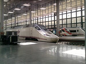
Cádiz railway station
Spanish railway station
Distance: Approx. 1416 meters
Latitude and longitude: 36.5279,-6.2868
Cádiz railway station is the main railway station of the Spanish city of Cádiz, Andalusia. It served over 1.2 million passengers in 2018, of which 350,000 were Cercanías Cádiz passengers.
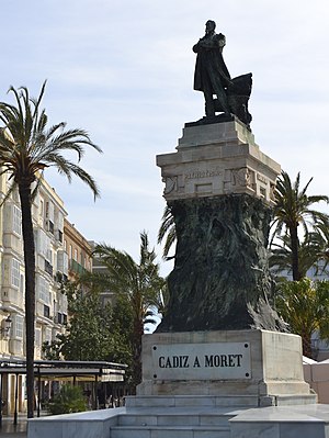
Monument to Moret (Cádiz)
Monument in Cádiz
Distance: Approx. 1966 meters
Latitude and longitude: 36.530264,-6.292209
The Monument to Moret is an instance of public art in Cádiz, Spain. Designed by Agustín Querol, it consists of a bronze statue of Liberal politician Segismundo Moret (who enjoyed the honorary recognition as "favourite son" of the City of Cádiz) put on top of a pedestal displaying elaborated allegorical reliefs.
Port of Cadiz Bay
Port facility serving Cádiz
Distance: Approx. 1503 meters
Latitude and longitude: 36.53333333,-6.26666667
The Port of Cadiz Bay is a port facility in Cadiz Bay serving the city and province of Cádiz in southern Spain. It consists of Cadiz harbour, Cabezuela on the south side of the bay, and Puerto de Santa Maria to the north.
Weather in this IP's area
clear sky
21 Celsius
21 Celsius
20 Celsius
21 Celsius
1011 hPa
68 %
1011 hPa
1011 hPa
10000 meters
3.09 m/s
90 degree
08:10:49
20:26:51