Country:
Region:
City:
Latitude and Longitude:
Time Zone:
Postal Code:
IP information under different IP Channel
ip-api
Country
Region
City
ASN
Time Zone
ISP
Blacklist
Proxy
Latitude
Longitude
Postal
Route
Luminati
Country
Region
md
City
torrelodones
ASN
Time Zone
Europe/Madrid
ISP
Orange Espagne SA
Latitude
Longitude
Postal
IPinfo
Country
Region
City
ASN
Time Zone
ISP
Blacklist
Proxy
Latitude
Longitude
Postal
Route
db-ip
Country
Region
City
ASN
Time Zone
ISP
Blacklist
Proxy
Latitude
Longitude
Postal
Route
ipdata
Country
Region
City
ASN
Time Zone
ISP
Blacklist
Proxy
Latitude
Longitude
Postal
Route
Popular places and events near this IP address

Collado Villalba
Place in Community of Madrid, Spain
Distance: Approx. 9434 meters
Latitude and longitude: 40.63333333,-4.00833333
Collado Villalba (Spanish pronunciation: [koˈʎaðo βiˈʎalβa]) is a municipality of the Community of Madrid, in central Spain. It is located 40.3 kilometres north-west of the city of Madrid, at an altitude of 917 meters above sea level. It has a population of 64,263 (2022), with a population density of about 2,400 per km2.

Colmenarejo
Place in Madrid, Spain
Distance: Approx. 7624 meters
Latitude and longitude: 40.56083333,-4.01694444
Colmenarejo (Spanish: [kolmenaˈɾexo] ) is a Spanish town and municipality in the Community of Madrid, located in the northwest of the region, in the foothills of the Sierra de Guadarrama, 899 meters high and 37 kilometers away from the capital. It is bordered to the north by El Escorial, to the east by Galapagar, to the south by Villanueva del Pardillo and to the west by Valdemorillo. Its only road access is the M 510, from Galapagar or from Valdemorillo.

Galapagar
Municipality in Community of Madrid, Spain
Distance: Approx. 6215 meters
Latitude and longitude: 40.57638889,-4.00194444
Galapagar is a town and municipality northwest of Madrid, Spain, situated in the autonomous community of the Community of Madrid. Of all the towns in the area, it was experiencing the most growth, mostly because of immigration and the conversion of old livestock fields into terrain for construction. Bordering with Collado Villalba, Colmenarejo, Torrelodones, Las Rozas de Madrid, El Escorial, San Lorenzo de El Escorial, Villanueva del Pardillo, Hoyo de Manzanares, Moralzarzal and Guadarrama.

Torrelodones
Municipality in Community of Madrid, Spain
Distance: Approx. 172 meters
Latitude and longitude: 40.57555556,-3.92916667
Torrelodones is a municipality in the northwest of the Autonomous Community of Madrid, Spain. It is situated 29 kilometers northwest from the city of Madrid. Because of its location between the Sierra de Guadarrama and the metropolitan area of the capital, it is linked to two districts in Madrid: the agricultural area of Guadarrama and the metropolitan area of Madrid.
Hoyo de Manzanares
Municipality in Madrid, Spain
Distance: Approx. 7619 meters
Latitude and longitude: 40.63333333,-3.88333333
Hoyo de Manzanares is a municipality of the Community of Madrid, Spain, and is located on the northwestern side of the Community of Madrid and to the south of the Sierra de Guadarrama. It has a stable population of roughly 7,457 residents (INE 2008), a statistic that has been increasing consistently from the economic crisis of 2008/9 onwards. The population also greatly increases during the summer due to an influx of various families who own summer houses in the area.

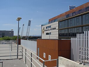
La Ciudad del Fútbol
Distance: Approx. 6043 meters
Latitude and longitude: 40.524,-3.901
La Ciudad del Fútbol de la Real Federación Española de Fútbol (English: The Football City of the Royal Spanish Football Federation) is a football training facility opened in 2003, serving as the headquarters of the Royal Spanish Football Federation as well as the official training centre of the Spanish football team. It is located in the municipality of Las Rozas de Madrid around 20 km northwest of the capital Madrid, within the Community of Madrid.

Church of la Asunción (Galapagar)
Cultural property in Galapagar, Spain
Distance: Approx. 6389 meters
Latitude and longitude: 40.578304,-4.003857
The Church of la Asunción (Spanish: Iglesia Parroquial de la Asunción) is a church located in Galapagar, Spain. It was declared Bien de Interés Cultural in 1995.

Watchtower of Torrelodones
Cultural property in Torrelodones, Spain
Distance: Approx. 337 meters
Latitude and longitude: 40.573877,-3.932473
The Watchtower of Torrelodones (Spanish: Atalaya de Torrelodones) is an Islamic-era construction located in the Spanish municipality of Torrelodones, Community of Madrid, Spain. It was erected at some point during the Umayyad period of Al-Andalus, between the ninth and eleventh centuries. The tower, which has the status of Asset of Cultural Interest, is one of the best preserved Islamic watchtowers in the Madrid region.

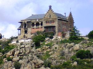
Palace of Canto del Pico
Emblematic property of cultural interest in Torrelodones, Madrid, Spain
Distance: Approx. 1689 meters
Latitude and longitude: 40.5891,-3.9255
The Palace of Canto del Pico (Spanish: Palacio del Canto del Pico) is a palace located in Torrelodones, Spain. It was declared Private property in 1930.
Weather in this IP's area
broken clouds
12 Celsius
11 Celsius
11 Celsius
13 Celsius
1024 hPa
68 %
1024 hPa
927 hPa
10000 meters
1.03 m/s
75 %
07:50:46
18:07:51