Country:
Region:
City:
Latitude and Longitude:
Time Zone:
Postal Code:
IP information under different IP Channel
ip-api
Country
Region
City
ASN
Time Zone
ISP
Blacklist
Proxy
Latitude
Longitude
Postal
Route
Luminati
Country
Region
md
City
lasrozasdemadrid
ASN
Time Zone
Europe/Madrid
ISP
Orange Espagne SA
Latitude
Longitude
Postal
IPinfo
Country
Region
City
ASN
Time Zone
ISP
Blacklist
Proxy
Latitude
Longitude
Postal
Route
db-ip
Country
Region
City
ASN
Time Zone
ISP
Blacklist
Proxy
Latitude
Longitude
Postal
Route
ipdata
Country
Region
City
ASN
Time Zone
ISP
Blacklist
Proxy
Latitude
Longitude
Postal
Route
Popular places and events near this IP address
Las Rozas de Madrid
Place in Community of Madrid, Spain
Distance: Approx. 7433 meters
Latitude and longitude: 40.49166667,-3.87333333
Las Rozas de Madrid (Spanish: [las ˈɾoθas ðe maˈðɾið] , or simply, Las Rozas [las ˈɾoθas]) is a municipality in the autonomous community of Madrid, Spain, with an area of 59 km² (22¾ sq. mi.).[1] The municipality is served by three Renfe railway stations– Las Rozas, Pinar de Las Rozas and Las Matas. Additional stops at Peñascales and El Tejar were closed.

Galapagar
Municipality in Community of Madrid, Spain
Distance: Approx. 9990 meters
Latitude and longitude: 40.57638889,-4.00194444
Galapagar is a town and municipality northwest of Madrid, Spain, situated in the autonomous community of the Community of Madrid. Of all the towns in the area, it was experiencing the most growth, mostly because of immigration and the conversion of old livestock fields into terrain for construction. Bordering with Collado Villalba, Colmenarejo, Torrelodones, Las Rozas de Madrid, El Escorial, San Lorenzo de El Escorial, Villanueva del Pardillo, Hoyo de Manzanares, Moralzarzal and Guadarrama.

Torrelodones
Municipality in Community of Madrid, Spain
Distance: Approx. 4127 meters
Latitude and longitude: 40.57555556,-3.92916667
Torrelodones is a municipality in the northwest of the Autonomous Community of Madrid, Spain. It is situated 29 kilometers northwest from the city of Madrid. Because of its location between the Sierra de Guadarrama and the metropolitan area of the capital, it is linked to two districts in Madrid: the agricultural area of Guadarrama and the metropolitan area of Madrid.

Monte de El Pardo
Natural landscape in Spain
Distance: Approx. 7796 meters
Latitude and longitude: 40.53333333,-3.8
The Monte de El Pardo is a large forested area in Madrid, Spain, extending roughly across one quarter of the total municipal area. The Monte de El Pardo has an area of 15289.12 ha. It was already mentioned as hunting ground in the Alfonso XI's Libro de la Montería (mid 14th century).
Hoyo de Manzanares
Municipality in Madrid, Spain
Distance: Approx. 8423 meters
Latitude and longitude: 40.63333333,-3.88333333
Hoyo de Manzanares is a municipality of the Community of Madrid, Spain, and is located on the northwestern side of the Community of Madrid and to the south of the Sierra de Guadarrama. It has a stable population of roughly 7,457 residents (INE 2008), a statistic that has been increasing consistently from the economic crisis of 2008/9 onwards. The population also greatly increases during the summer due to an influx of various families who own summer houses in the area.

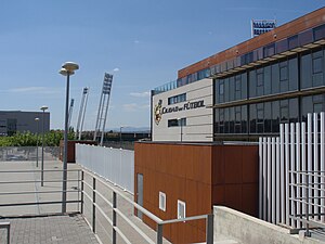
La Ciudad del Fútbol
Distance: Approx. 3950 meters
Latitude and longitude: 40.524,-3.901
La Ciudad del Fútbol de la Real Federación Española de Fútbol (English: The Football City of the Royal Spanish Football Federation) is a football training facility opened in 2003, serving as the headquarters of the Royal Spanish Football Federation as well as the official training centre of the Spanish football team. It is located in the municipality of Las Rozas de Madrid around 20 km northwest of the capital Madrid, within the Community of Madrid.

Watchtower of Torrelodones
Cultural property in Torrelodones, Spain
Distance: Approx. 4292 meters
Latitude and longitude: 40.573877,-3.932473
The Watchtower of Torrelodones (Spanish: Atalaya de Torrelodones) is an Islamic-era construction located in the Spanish municipality of Torrelodones, Community of Madrid, Spain. It was erected at some point during the Umayyad period of Al-Andalus, between the ninth and eleventh centuries. The tower, which has the status of Asset of Cultural Interest, is one of the best preserved Islamic watchtowers in the Madrid region.

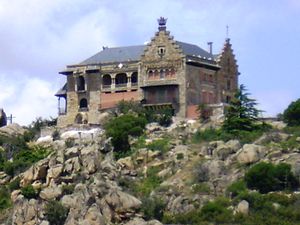
Palace of Canto del Pico
Emblematic property of cultural interest in Torrelodones, Madrid, Spain
Distance: Approx. 4811 meters
Latitude and longitude: 40.5891,-3.9255
The Palace of Canto del Pico (Spanish: Palacio del Canto del Pico) is a palace located in Torrelodones, Spain. It was declared Private property in 1930.

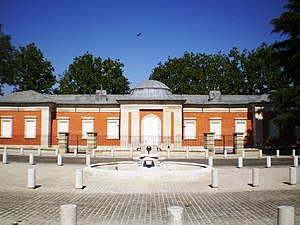
Casita del Príncipe (El Pardo)
Building in Spain
Distance: Approx. 9889 meters
Latitude and longitude: 40.52333333,-3.77861111
The Casita del Príncipe (Spanish for 'Cottage of the Prince') is an eighteenth-century house near the Royal Palace of El Pardo which is set in a hunting estate north of Madrid.

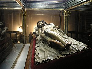
Cristo Yacente of El Pardo
Image of the dead Christ
Distance: Approx. 9308 meters
Latitude and longitude: 40.51903611,-3.78885
The Cristo Yacente (Dead Christ) of El Pardo, is a life-size polychromed sculpture by Spanish sculptor Gregorio Fernández, executed between 1614 and 1615. Housed in a chapel of the Capuchin Monastery of El Pardo (Madrid), the sculpture was commissioned by King Philip III to celebrate the birth of his son Philip IV. The Cristo yacente of El Pardo is the most famous of the fourteen "Cristos" produced by Fernández and his workshop. As devotional images, many of them were processed during Holy Week with other “pasos” (elaborate religious floats adorned with sculptures depicting scenes from the Passion of Christ).

Mingorrubio Cemetery
Cemetery in Madrid, Spain
Distance: Approx. 8778 meters
Latitude and longitude: 40.53666667,-3.78638889
The Mingorrubio Cemetery (Spanish: Cementerio de Mingorrubio), also called the Cemetery of El Pardo (Spanish: Cementerio de El Pardo), is a municipal cemetery on the edge of Madrid, Spain. Mingorrubio is a neighborhood in the northern district of Fuencarral-El Pardo.
Weather in this IP's area
broken clouds
12 Celsius
11 Celsius
11 Celsius
13 Celsius
1024 hPa
73 %
1024 hPa
939 hPa
10000 meters
1.03 m/s
75 %
07:50:34
18:07:43
