Country:
Region:
City:
Latitude and Longitude:
Time Zone:
Postal Code:
IP information under different IP Channel
ip-api
Country
Region
City
ASN
Time Zone
ISP
Blacklist
Proxy
Latitude
Longitude
Postal
Route
Luminati
Country
ASN
Time Zone
America/Chicago
ISP
FDCSERVERS
Latitude
Longitude
Postal
IPinfo
Country
Region
City
ASN
Time Zone
ISP
Blacklist
Proxy
Latitude
Longitude
Postal
Route
db-ip
Country
Region
City
ASN
Time Zone
ISP
Blacklist
Proxy
Latitude
Longitude
Postal
Route
ipdata
Country
Region
City
ASN
Time Zone
ISP
Blacklist
Proxy
Latitude
Longitude
Postal
Route
Popular places and events near this IP address

United Nations Economic and Social Commission for Western Asia
Regional commissions of the United Nations Economic and Social Council
Distance: Approx. 107 meters
Latitude and longitude: 33.8946,35.5021
The United Nations Economic and Social Commission for West Asia (ESCWA; Arabic: الإسكوا) is one of five regional commissions under the jurisdiction of the United Nations Economic and Social Council. The role of the Commission is to promote economic and social development of Western Asia through regional and subregional cooperation and integration. The Commission is composed of 21 member states, all from the regions of North Africa and the Middle East.

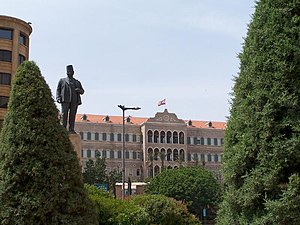
Grand Serail of Beirut
Historic site in Beirut, Lebanon
Distance: Approx. 258 meters
Latitude and longitude: 33.895926,35.500934
The Grand Serail (Arabic: السراي الكبير, al-Sarāy al-Kabir; also known as the Government Palace) is the headquarters of the Prime Minister of Lebanon. It is situated atop a hill in downtown Beirut a few blocks away from the Lebanese Parliament building. The Grand Serail is a historic building, the most important of three Ottoman monuments on the Serail hill, the others being the Council for Development and Reconstruction and the Hamidiyyeh clock tower.

National Evangelical Church of Beirut
Distance: Approx. 114 meters
Latitude and longitude: 33.89471,35.501477
The National Evangelical Church of Beirut (NEC) is a reformed church in Beirut, member of the National Evangelical Church Union of Lebanon.

Ministry of Finance (Lebanon)
Distance: Approx. 296 meters
Latitude and longitude: 33.89583333,35.50361111
The Ministry of Finance (MOF; Arabic: وزارة المالية) is a ministry of the government of Lebanon.

Gibran Khalil Gibran Garden
Public garden in Beirut, Lebanon
Distance: Approx. 138 meters
Latitude and longitude: 33.8942113,35.5003362
The Gibran Khalil Gibran Garden (Arabic: حديقة جبران خليل جبران) is a 6,000-square-meter public garden in the Centre Ville area of Beirut, Lebanon, facing the UN House, the headquarters of ESCWA, the United Nations Economic and Social Commission for Western Asia. The garden, which is named in honor of the Lebanese–American writer, poet and visual artist Kahlil Gibran, features two circular lawns, a fountain, and modern sculpture, including a bust of Gibran. The garden is often used as a venue for peaceful and democratic demonstrations and sit-ins.

Maronite Cathedral of Saint George, Beirut
Church in Beirut, Lebanon
Distance: Approx. 377 meters
Latitude and longitude: 33.895272,35.50531
Saint George Maronite Cathedral (Arabic: كاتدرائية مار جرجس للموارنة) is the cathedral of the Maronite Catholic Archeparchy of Beirut, Archdiocese of the city of Beirut, Lebanon. Its construction, with a Neoclassical facade, interior and plan inspired by the Basilica di Santa Maria Maggiore, began in 1884 and ended in 1894. The cathedral was heavily hit and shelled during the Lebanese civil war and was plundered and defaced.

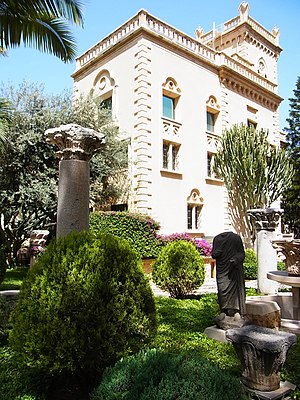
Robert Mouawad Private Museum
Museum in Beirut, Lebanon
Distance: Approx. 310 meters
Latitude and longitude: 33.895325,35.498981
The Robert Mouawad Private Museum (Arabic: متحف روبير معوض الخاص) is a private residence in Beirut's Zokak el-Blat quarter that was turned into a museum by the Lebanese businessman Robert Mouawad. The palace was built in the neo-gothic style by the Lebanese politician and art collector Henri Philippe Pharaoun in 1891. The museum was inaugurated on 11 May 2006.

Zuqaq al-Blat
Quarter of Beirut
Distance: Approx. 352 meters
Latitude and longitude: 33.89222222,35.49833333
Zuqaq al-Blat (Arabic: زقاق البلاط) is one of the twelve quarters of Beirut.

Law school of Berytus
Ancient school of Roman law, to 551 AD
Distance: Approx. 369 meters
Latitude and longitude: 33.89611111,35.50444444
The law school of Berytus (also known as the law school of Beirut) was a center for the study of Roman law in classical antiquity located in Berytus (modern-day Beirut, Lebanon). It flourished under the patronage of the Roman emperors and functioned as the Roman Empire's preeminent center of jurisprudence until its destruction in AD 551. The law schools of the Roman Empire established organized repositories of imperial constitutions and institutionalized the study and practice of jurisprudence to relieve the busy imperial courts.

Riad Al Solh Square
Square in Beirut, Lebanon
Distance: Approx. 192 meters
Latitude and longitude: 33.89511111,35.50288889
Riad Al Solh Square (Arabic: ساحة رياض الصلح) is a square in the heart of downtown Beirut, Lebanon.

Roman Baths, Beirut
Historic site in downtown Beirut, Lebanon
Distance: Approx. 366 meters
Latitude and longitude: 33.8969,35.5026
The Roman Berytus (Roman Baths) are located in the middle of downtown Beirut, Lebanon between Banks Street and Capuchin Street. The remains of a Roman bath of Berytus now surrounded by government buildings were found and conserved for posterity.

Maronite Catholic Archeparchy of Beirut
Eastern Catholic jurisdiction in Lebanon
Distance: Approx. 338 meters
Latitude and longitude: 33.895,35.505
The Archeparchy of Beirut (in Latin: Archeparchia Berytensis Maronitarum) is an archeparchial seat of the Maronite Church immediately subject to the Holy See in Lebanon. As of 2012, there were 232,000 baptized. It is currently ruled by Archeparch Paul Abdel Sater.
Weather in this IP's area
broken clouds
18 Celsius
18 Celsius
16 Celsius
18 Celsius
1015 hPa
82 %
1015 hPa
1007 hPa
8000 meters
6.17 m/s
180 degree
75 %
06:13:26
16:33:17