149.54.10.45 - IP Lookup: Free IP Address Lookup, Postal Code Lookup, IP Location Lookup, IP ASN, Public IP
Country:
Region:
City:
Location:
Time Zone:
Postal Code:
ISP:
ASN:
language:
User-Agent:
Proxy IP:
Blacklist:
IP information under different IP Channel
ip-api
Country
Region
City
ASN
Time Zone
ISP
Blacklist
Proxy
Latitude
Longitude
Postal
Route
db-ip
Country
Region
City
ASN
Time Zone
ISP
Blacklist
Proxy
Latitude
Longitude
Postal
Route
IPinfo
Country
Region
City
ASN
Time Zone
ISP
Blacklist
Proxy
Latitude
Longitude
Postal
Route
IP2Location
149.54.10.45Country
Region
kabul
City
paghman
Time Zone
Asia/Kabul
ISP
Language
User-Agent
Latitude
Longitude
Postal
ipdata
Country
Region
City
ASN
Time Zone
ISP
Blacklist
Proxy
Latitude
Longitude
Postal
Route
Popular places and events near this IP address
Paghman
District in Kabul Province, Afghanistan
Distance: Approx. 554 meters
Latitude and longitude: 34.58333333,68.95
Paghman (Dari/Pashto:پغمان) is a town in the hills near Afghanistan's capital of Kabul. It is the seat of the Paghman District (in the western part of Kabul Province) which has a population of about 120,000 (2002 official UNHCR est.), mainly Pashtuns and Tajiks. The gardens of Paghman are a major tourist attraction, and the reason for the city being known as the garden capital of Afghanistan.
Kabul Golf Club
Distance: Approx. 8575 meters
Latitude and longitude: 34.55023,69.03517
The Kabul Golf Club is a nine-hole golf course located near Qargha, around 7 miles from the center of Kabul, Afghanistan.

Paghman District
District in Kabul Province, Afghanistan
Distance: Approx. 557 meters
Latitude and longitude: 34.5833,68.95
Paghman District is in the western part of Kabul Province, Afghanistan. It has a population of over 120,000 people (2002 UNHCR estimate). Paghman district borders Wardak and Parwan provinces to the west, Shakardara District to the north, Kabul to the east and Char Asiab District to the south-east.

Qargha Dam
Dam in Kabul Province of Afghanistan
Distance: Approx. 8372 meters
Latitude and longitude: 34.55294,69.03442
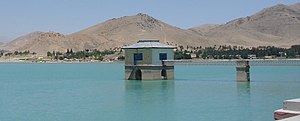
Qargha Dam (Dari: بند قرغه; Pashto: د قرغې بند) is located in the town of Qargha, about 10 mi (16 km) west from the Shahr-e Naw neighborhood of Kabul, Afghanistan. It is an embankment dam built on the Paghman River, with a side channel spillway under the road running on top of the dam. Its reservoir can hold up to 12,000,000 m3 (420,000,000 cu ft) of water, which is used for irrigation purposes.

Qargha
Town in Kabul Province of Afghanistan
Distance: Approx. 9798 meters
Latitude and longitude: 34.55,69.05
Qargha (Dari: قرغه; Pashto: قرغې) is a town located to the west of Kabul, Afghanistan, where many people go for recreation and entertainment purposes. Its main attraction is the Qargha Dam, which is named after the town. There are also parks, amusement rides, boat rides, horse rides, and many Afghan restaurants with open lounge areas.
Paghman Hill Castle
Palace in Afghanistan
Distance: Approx. 1511 meters
Latitude and longitude: 34.584844,68.969464
Paghman Hill Castle, also known as Paghman Palace (Pashto: د پغمان ماڼۍ), is located in the town of Paghman in Afghanistan, a short distance northwest of the city of Kabul. The site opened to the public in 2014 and is visited by many tourists, especially during major festivals. The castle and surrounding areas are sometimes used as a location to host foreign guests.

Taq-e Zafar
Memorial arch in Paghman, Afghanistan
Distance: Approx. 551 meters
Latitude and longitude: 34.590011,68.9584813
The Taq-e Zafar (Persian: طاق ظفر, English: Arch of Victory) is a memorial arch located at the front of the gardens in Paghman, Afghanistan. The famous victory arch commemorates Afghan independence after the Third Anglo-Afghan War in 1919.
Weather in this IP's area
scattered clouds
-2 Celsius
-6 Celsius
-2 Celsius
-2 Celsius
1021 hPa
34 %
1021 hPa
751 hPa
10000 meters
3.15 m/s
2.29 m/s
289 degree
49 %

