149.5.234.16 - IP Lookup: Free IP Address Lookup, Postal Code Lookup, IP Location Lookup, IP ASN, Public IP
Country:
Region:
City:
Location:
Time Zone:
Postal Code:
IP information under different IP Channel
ip-api
Country
Region
City
ASN
Time Zone
ISP
Blacklist
Proxy
Latitude
Longitude
Postal
Route
Luminati
Country
Region
pac
City
valbonne
ASN
Time Zone
Europe/Paris
ISP
FORTINET
Latitude
Longitude
Postal
IPinfo
Country
Region
City
ASN
Time Zone
ISP
Blacklist
Proxy
Latitude
Longitude
Postal
Route
IP2Location
149.5.234.16Country
Region
provence-alpes-cote-d'azur
City
valbonne
Time Zone
Europe/Paris
ISP
Language
User-Agent
Latitude
Longitude
Postal
db-ip
Country
Region
City
ASN
Time Zone
ISP
Blacklist
Proxy
Latitude
Longitude
Postal
Route
ipdata
Country
Region
City
ASN
Time Zone
ISP
Blacklist
Proxy
Latitude
Longitude
Postal
Route
Popular places and events near this IP address

Valbonne
Commune in Provence-Alpes-Côte d'Azur, France
Distance: Approx. 1349 meters
Latitude and longitude: 43.6424,7.0095
Valbonne (French pronunciation: [valbɔn]; Occitan: Vauboa) is a commune near Nice in the Alpes-Maritimes department in the Provence-Alpes-Côte d'Azur region in southeastern France. Valbonne means "the good valley" in Provençal and translates to "Vaubona" in Occitan. The commune is part of the Communauté d'agglomération de Sophia Antipolis.

Mougins
Commune in Provence-Alpes-Côte d'Azur, France
Distance: Approx. 3584 meters
Latitude and longitude: 43.6008,6.9956
Mougins (French pronunciation: [muʒɛ̃] ; Occitan: Mogins [muˈʒis]; Latin: Muginum [muːˈɡiːnũː]) is a commune in the Alpes-Maritimes department in the region of Provence-Alpes-Côte d'Azur, Southeastern France. It is located on the heights of Cannes, in the arrondissement of Grasse. Mougins is a 15-minute drive from Cannes.

Opio, Alpes-Maritimes
Commune in Provence-Alpes-Côte d'Azur, France
Distance: Approx. 3972 meters
Latitude and longitude: 43.6667,6.9833
Opio (French pronunciation: [ɔpjo]; Occitan: Opiá) is a commune in the Alpes-Maritimes department in southeastern France situated near Grasse.
Mouans-Sartoux
Commune in Provence-Alpes-Côte d'Azur, France
Distance: Approx. 2514 meters
Latitude and longitude: 43.6211,6.9725
Mouans-Sartoux (French pronunciation: [mwɑ̃ saʁtu]; known in Occitan as Moans e Sartòu or Moans e Sartol) is a commune in the Alpes-Maritimes department in southeastern France. The inhabitants are called Mouansois. The commune of Sartoux was combined with the commune of Mouans, to take the combined name of Mouans-Sartoux by order of Napoleon III on 28 March 1858.
Mougins School
International school in Mougins, France
Distance: Approx. 2653 meters
Latitude and longitude: 43.6125,7.01611111
Mougins British International School, previously known as Mougins School is an international school situated in Mougins, France. It was established in 1964 and moved to its present site on the high technology park of Sophia Antipolis in 1987. The school was purchased by international education company Globeducate in 2021.

Plascassier
Distance: Approx. 2288 meters
Latitude and longitude: 43.65,6.98333333
Plascassier is located between Valbonne (2.8 km) and Grasse (7 km) and only 31 km away from Nice airport. Although bordered by several communes—Valbonne, Opio, Mouans-Sartoux and Châteauneuf-de-Grasse—it falls under the jurisdictional umbrella of Grasse. French singer Édith Piaf died here on 10 October 1963.
La Pitchoune
Stucco house in France
Distance: Approx. 2395 meters
Latitude and longitude: 43.6492,6.9797
La Pitchoune is a small stucco house that Julia Child and her husband, Paul, built in the Provençal village of Plascassier in France in the early 1960s. La Pitchoune is a Provençal expression for "the little one", deriving from the Occitan word pichon. The cottage was built on property belonging to Simone Beck and her husband Jean Fischbacher with a "handshake" promise they would turn it over to the Fischbachers when they finished their use.
Mougins Museum of Classical Art
Art museum in Mougins, France
Distance: Approx. 3532 meters
Latitude and longitude: 43.60131667,6.99485
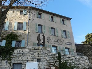
The MACM, the Mougins Museum of Classical Art (Musée d’Art Classique de Mougins), private museum inaugurated in June 2011 in the village of Mougins in the Alpes-Maritimes department, France has closed its doors in August 2023 to make way for a new museum, FAMM (Female Artists of the Mougins Museum) opening in June 2024. This new museum will showcase works by artists from The Levett Collection. Artists such as Joan Mitchell, Lee Krasner, Helen Frankenthaler, Grace Hartigan, Elaine de Kooning, Louise Bourgeois, Tracey Emin, Sarah Lucas, Howardena Pindell, Joan Semmel, Nancy Graves, Cecily Brown, Carrie Mae Weems, Barbara Hepworth, Marlene Dumas, Alma Thomas, Leonor Fini, Franciszka Themerson, Sahara Longe, Elizabeth Colomba will be exhibited, as well as many more.
Communauté d'agglomération de Sophia Antipolis
Communauté d'agglomération in Provence-Alpes-Côte d'Azur, France
Distance: Approx. 4051 meters
Latitude and longitude: 43.62235,7.04721
The Communauté d'agglomération de Sophia Antipolis (CASA) is the communauté d'agglomération, an intercommunal structure, centred on the city of Antibes. It is located in the Alpes-Maritimes department, in the Provence-Alpes-Côte d'Azur region, southeastern France. It was created in 2002, and takes its name from the technology park Sophia Antipolis.

Canton of Valbonne
Canton in Provence-Alpes-Côte d'Azur, France
Distance: Approx. 1181 meters
Latitude and longitude: 43.64,7.01
The canton of Valbonne is an administrative division of the Alpes-Maritimes department, southeastern France. It was created at the French canton reorganisation which came into effect in March 2015. Its seat is in Valbonne.
Mougins Center of Photography
French gallery
Distance: Approx. 3627 meters
Latitude and longitude: 43.60043,6.9953
The Mougins Center of Photography (Centre de Photographie de Mougins) is a photography gallery located in the village of Mougins, in the Alpes-Maritimes department, France. It opened in July 2021. The building was previously home to the photography museum of André Villiers, which closed in 2018.
Mouans-Sartoux station
Railway station in Mouans-Sartoux, France
Distance: Approx. 2433 meters
Latitude and longitude: 43.62027778,6.97444444
Mouans-Sartoux station (French: Gare de Mouans-Sartoux) is a railway station serving Mouans-Sartoux, Alpes-Maritimes department, southeastern France. The station is located on Cannes-la-Bocca to Grasse Railway Line. The station opened in 1871, and was closed after 1938 until it was rebuilt and reopened in 2005.
Weather in this IP's area
moderate rain
9 Celsius
8 Celsius
9 Celsius
10 Celsius
1005 hPa
96 %
1005 hPa
978 hPa
5000 meters
2.57 m/s
350 degree
100 %


