Country:
 Turkey
Region:
City:
Latitude and Longitude:
Time Zone:
Postal Code:
IP information under different IP Channel
ip-api
Country
Region
City
ASN
Time Zone
ISP
Blacklist
Proxy
Latitude
Longitude
Postal
Route
IPinfo
Country
Region
City
ASN
Time Zone
ISP
Blacklist
Proxy
Latitude
Longitude
Postal
Route
MaxMind
Country
Region
City
ASN
Time Zone
ISP
Blacklist
Proxy
Latitude
Longitude
Postal
Route
Luminati
Country
TRASN
Time Zone
Europe/Istanbul
ISP
Gibirnet Iletisim Hizmetleri Sanayi Ve Ticaret Limited Sirketi
Latitude
Longitude
Postal
db-ip
Country
Region
City
ASN
Time Zone
ISP
Blacklist
Proxy
Latitude
Longitude
Postal
Route
ipdata
Country
Region
City
ASN
Time Zone
ISP
Blacklist
Proxy
Latitude
Longitude
Postal
Route
Popular places and events near this IP address
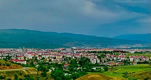
Bingöl
City in Bingöl Province, Turkey
Distance: Approx. 691 meters
Latitude and longitude: 38.88611111,40.50166667
Bingöl (Armenian: Ճապաղջուր, romanized: Chapaghjur, Kurdish: Çewlik, Zazaki: Çewlîg), known as Çapakçur before 1944, is a city in Turkey. It is the seat of Bingöl Province and Bingöl District, having a population of 133,423 (2022).
Akdurmuş, Bingöl
Village in Bingöl Province, Turkey
Distance: Approx. 5222 meters
Latitude and longitude: 38.841,40.472
Akdurmuş (Kurdish: Guldar) is a village in the Bingöl District, Bingöl Province, Turkey. The village is populated by Kurds of the Az tribe and had a population of 175 in 2021. It is located at an altitude of 1,325 m (4,347 ft).

Bingöl University
Public university in Bingöl, Turkey
Distance: Approx. 1024 meters
Latitude and longitude: 38.8852,40.5057
Bingöl University (Turkish: Bingöl Üniversitesi) is a university located in Bingöl, Turkey. It was established in 2007. The University is led by Prof.

Bingöl District
District of Bingöl Province, Turkey
Distance: Approx. 550 meters
Latitude and longitude: 38.88333333,40.5
Bingöl District (also: Merkez, meaning "central") is a district of Bingöl Province of Turkey. Its seat is the city Bingöl. Its area is 1,814 km2, and its population is 171,752 (2022).
Üçyaka, Bingöl
Village in Bingöl Province, Turkey
Distance: Approx. 5649 meters
Latitude and longitude: 38.853,40.443
Üçyaka (Kurdish: Az) is a village in the Bingöl District, Bingöl Province, Turkey. The village is populated by Kurds of the Az tribe and had a population of 74 in 2021.
Aşağıakpınar, Bingöl
Village in Bingöl Province, Turkey
Distance: Approx. 3201 meters
Latitude and longitude: 38.86,40.475
Aşağıakpınar (Kurdish: Wusfon) is a village in the Bingöl District, Bingöl Province, Turkey. The village is populated by Kurds of the Az tribe and had a population of 1,102 in 2021. The hamlet of Eskiköy is attached to the village.
Yukarıakpınar, Bingöl
Village in Bingöl Province, Turkey
Distance: Approx. 3301 meters
Latitude and longitude: 38.861,40.471
Yukarıakpınar (Kurdish: Sepenê) is a village in the Bingöl District, Bingöl Province, Turkey. The village is populated by Kurds of the Az tribe and had a population of 81 in 2021. The hamlet of Mirzan is attached to the village.
Küçüktekören, Bingöl
Village in Bingöl Province, Turkey
Distance: Approx. 3005 meters
Latitude and longitude: 38.858,40.499
Küçüktekören (Kurdish: Zeyneb) is a village in the Bingöl District, Bingöl Province, Turkey. The village is populated by Kurds of the Az tribe and had a population of 210 in 2021. The hamlet of Zeynep is attached to the village.
Dügernan, Bingöl
Village in Bingöl Province, Turkey
Distance: Approx. 5048 meters
Latitude and longitude: 38.875,40.437
Dügernan (formerly Alıncık, Kurdish: Dugernan) is a village in the Bingöl District, Bingöl Province, Turkey. The village is populated by Kurds of the Az tribe and had a population of 44 in 2021.
Güveçli, Bingöl
Village in Bingöl Province, Turkey
Distance: Approx. 5036 meters
Latitude and longitude: 38.846,40.524
Güveçli (Kurdish: Sinêwelan) is a village in the Bingöl District, Bingöl Province, Turkey. The village is populated by Kurds of the Kejan tribe and had a population of 1,268 in 2021. The hamlets of Karaca and Yaprak are attached to the village.
Kurudere, Bingöl
Village in Bingöl Province, Turkey
Distance: Approx. 2967 meters
Latitude and longitude: 38.903,40.469
Kurudere (Kurdish: Deroziwa) is a village in the Bingöl District, Bingöl Province, Turkey. The village had a population of 300 in 2021. The hamlets of Aydoğdu, Bölücek and Kamışlı are attached to the village.
Çayboyu, Bingöl
Village in Bingöl Province, Turkey
Distance: Approx. 2610 meters
Latitude and longitude: 38.904,40.511
Çayboyu (Kurdish: Xêyd) is a village in the Bingöl District, Bingöl Province, Turkey. The village had a population of 75 in 2021.
Weather in this IP's area
clear sky
14 Celsius
12 Celsius
14 Celsius
14 Celsius
1011 hPa
31 %
1011 hPa
883 hPa
10000 meters
3.35 m/s
2.91 m/s
320 degree
3 %
06:30:24
17:35:32