Country:
Region:
City:
Latitude and Longitude:
Time Zone:
Postal Code:
IP information under different IP Channel
ip-api
Country
Region
City
ASN
Time Zone
ISP
Blacklist
Proxy
Latitude
Longitude
Postal
Route
Luminati
Country
ASN
Time Zone
America/Chicago
ISP
SonderCloud Limited
Latitude
Longitude
Postal
IPinfo
Country
Region
City
ASN
Time Zone
ISP
Blacklist
Proxy
Latitude
Longitude
Postal
Route
db-ip
Country
Region
City
ASN
Time Zone
ISP
Blacklist
Proxy
Latitude
Longitude
Postal
Route
ipdata
Country
Region
City
ASN
Time Zone
ISP
Blacklist
Proxy
Latitude
Longitude
Postal
Route
Popular places and events near this IP address

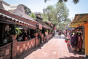
Olvera Street
Historic district in Los Angeles, United States
Distance: Approx. 284 meters
Latitude and longitude: 34.057495,-118.237996
Olvera Street, commonly known by its Spanish name Calle Olvera, is a historic pedestrian street in El Pueblo de Los Ángeles, the historic center of Los Angeles. The street is located off of the Plaza de Los Ángeles, the oldest plaza in California, which served as the center of the city life through the Spanish and Mexican eras into the early American era, following the Conquest of California. Restaurants, vendors, and public establishments line the street.

Philippe's
Restaurant in Los Angeles, California
Distance: Approx. 241 meters
Latitude and longitude: 34.059588,-118.236896
Philippe's, or "Philippe the Original" ( fi-LEEPS) is a restaurant located in downtown Los Angeles, California. The restaurant is well known for continuously operating since 1908, making it one of the oldest restaurants in Los Angeles. It is also renowned for claiming to be the inventor of the French dip sandwich.
Ávila Adobe
Historic building in Los Angeles, California
Distance: Approx. 274 meters
Latitude and longitude: 34.05722222,-118.23777778
The Ávila Adobe, built in 1818 by Francisco Ávila, is the oldest standing residence in the city of Los Angeles, California. Avila Adobe is located in the paseo of historic Olvera Street, a part of the Los Angeles Plaza Historic District, a California State Historic Park. The building itself is registered as California Historical Landmark #145, while the entire historic district is listed both on the National Register of Historic Places and as a Los Angeles Historic-Cultural Monument.

Los Angeles Chinese massacre of 1871
Riotous lynching
Distance: Approx. 314 meters
Latitude and longitude: 34.0565,-118.2378
The Los Angeles Chinese massacre of 1871 was a racial massacre targeting Chinese immigrants in Los Angeles, California, United States that occurred on October 24, 1871. Approximately 500 white and Latino Americans attacked, harassed, robbed, and murdered the ethnic Chinese residents in what is today referred to as the old Chinatown neighborhood. The massacre took place on Calle de los Negros, also referred to as "Negro Alley".

El Pueblo de Los Ángeles Historical Monument
United States historic place
Distance: Approx. 287 meters
Latitude and longitude: 34.05694444,-118.23777778
El Pueblo de Los Ángeles Historical Monument, also known as Los Angeles Plaza Historic District and formerly known as El Pueblo de Los Ángeles State Historic Park, is a historic district taking in the oldest section of Los Angeles, known for many years as El Pueblo de Nuestra Señora la Reina de los Ángeles del Río de Porciúncula. The district, centered on the old plaza, was the city's center under Spanish (1781–1821), Mexican (1821–1847), and United States (after 1847) rule through most of the 19th century. The 44-acre park area was designated a state historic monument in 1953 and listed on the National Register of Historic Places in 1972.

Plaza Substation
United States historic place
Distance: Approx. 304 meters
Latitude and longitude: 34.05708333,-118.23805556
The Plaza Substation was an electrical substation that formed a part of the "Yellow Car" streetcar system operated by the Los Angeles Railway from the early 1900s until 1963. After being threatened with demolition in the 1970s, the Plaza Substation was added to the National Register of Historic Places in 1978.
U.S. Post Office-Los Angeles Terminal Annex
United States historic place
Distance: Approx. 213 meters
Latitude and longitude: 34.06,-118.23527778
The United States Post Office – Los Angeles Terminal Annex, also known simply as Terminal Annex, located at 900 North Alameda Street in Los Angeles, California, was the central mail processing facility for Los Angeles, from 1940 to 1989. Across Cesar Chavez Avenue from Union Station, the Mission Revival and Spanish Colonial Revival building of Terminal Annex, which was designed by Gilbert Stanley Underwood, was added to the National Register of Historic Places in 1985.

Metro Headquarters Building
Government office in Los Angeles, US
Distance: Approx. 264 meters
Latitude and longitude: 34.05644444,-118.23294444
The Metro Headquarters Building (or One Gateway Plaza) is a 398 ft (121 m) high rise office tower in Los Angeles, California. It is located in Northeastern Downtown Los Angeles, east across the tracks from Union Station. Completed in 1995, it serves as the main headquarters for the Los Angeles County Metropolitan Transportation Authority.

Los Angeles Plaza
Distance: Approx. 287 meters
Latitude and longitude: 34.056944,-118.237778
Los Angeles Plaza or Plaza de Los Ángeles is located in Los Angeles, California. It is the central point of the Los Angeles Plaza Historic District. When Spanish Governor Felipe de Neve founded the Pueblo de Los Ángeles, his first act was to locate a plaza for the geographical center from which his town should radiate.
Men's Central Jail
Jail in Los Angeles, California, United States
Distance: Approx. 286 meters
Latitude and longitude: 34.059,-118.2321
Men's Central Jail is a Los Angeles County Sheriff's Department county jail for men in Los Angeles, Los Angeles County, California, United States. Built in 1963, it is one of the oldest county jails in California. The Men's Central Jail is located at 441 Bauchet St., Los Angeles 90012.

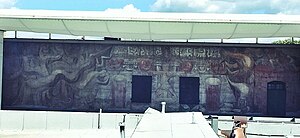
América Tropical: Oprimida y Destrozada por los Imperialismos
1932 mural by David Alfaro Siqueiros
Distance: Approx. 257 meters
Latitude and longitude: 34.05791667,-118.23777778
América Tropical is a 98-foot wide fresco mural created in 1932 by David Alfaro Siqueiros and other artists in Los Angeles, California, on a second-level exterior wall of the Italian Hall. It was painted over soon after its completion on an external wall of the Italian Hall on Olvera Street, in El Pueblo de Los Angeles Historical Monument of Downtown Los Angeles. It was restored and revealed to the public in 2012, 80 years to the day after its first unveiling.

Equestrian statue of Antonio Aguilar
Equestrian statue in Los Angeles, California, U.S.
Distance: Approx. 296 meters
Latitude and longitude: 34.05672222,-118.23775
An equestrian statue of Antonio Aguilar is installed in Los Angeles' El Pueblo de Los Ángeles Historical Monument, in the U.S. state of California. The statue is located on the corner of Los Angeles Street and Alameda Street, in front of the city's Union Station.
Weather in this IP's area
clear sky
24 Celsius
23 Celsius
22 Celsius
26 Celsius
1016 hPa
30 %
1016 hPa
1006 hPa
10000 meters
5.14 m/s
250 degree
06:15:48
16:57:13

