Country:
 Turkey
Region:
City:
Latitude and Longitude:
Time Zone:
Postal Code:
IP information under different IP Channel
ip-api
Country
Region
City
ASN
Time Zone
ISP
Blacklist
Proxy
Latitude
Longitude
Postal
Route
IPinfo
Country
Region
City
ASN
Time Zone
ISP
Blacklist
Proxy
Latitude
Longitude
Postal
Route
MaxMind
Country
Region
City
ASN
Time Zone
ISP
Blacklist
Proxy
Latitude
Longitude
Postal
Route
Luminati
Country
TRASN
Time Zone
Europe/Istanbul
ISP
PENTECH BILISIM TEKNOLOJILERI SANAYI VE TICARET LIMITED SIRKETi
Latitude
Longitude
Postal
db-ip
Country
Region
City
ASN
Time Zone
ISP
Blacklist
Proxy
Latitude
Longitude
Postal
Route
ipdata
Country
Region
City
ASN
Time Zone
ISP
Blacklist
Proxy
Latitude
Longitude
Postal
Route
Popular places and events near this IP address
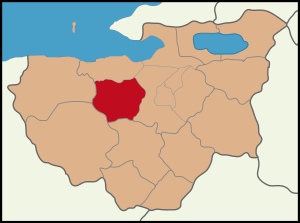
Nilüfer, Bursa
District of Bursa Province, Turkey
Distance: Approx. 9124 meters
Latitude and longitude: 40.28333333,28.95
Nilüfer (Turkish: [nilyˈfæɾ]) is a municipality and district of Bursa Province, Turkey. Its area is 552 km2, and its population is 536,365 (2022). Established in 1987, it is one of the seventeen districts of Bursa Province.
Kurşunlu, Gemlik
Neighbourhood in Gemlik, Bursa, Turkey
Distance: Approx. 7742 meters
Latitude and longitude: 40.36,29.02111111
Kurşunlu is a neighbourhood in the municipality and district of Gemlik, Bursa Province, Turkey. Its population is 1,574 (2022). It lies on the Gulf of Gemlik (Marmara Sea), at the foot of a range of hills of about 1,000 ft (300 m).
Mayor Synagogue (Bursa)
Former synagogue in Bursa, Turkey
Distance: Approx. 8004 meters
Latitude and longitude: 40.2292,29.0917
The Mayor Synagogue (Turkish: Sinagoga Mayor), or Synagogue Mejor, is a former Jewish congregation and synagogue located on Arap Şükrü (Sakarya) Street in Bursa, Turkey. No longer used as a synagogue, the building is used as a mikveh.
Demirtaş Dam
Dam in Turkey
Distance: Approx. 4992 meters
Latitude and longitude: 40.288,29.1141
Demirtaş Dam is a dam in Turkey. It was built in 1982 and commissioned in 1983. The development was backed by the Turkish State Hydraulic Works.
Selçukgazi Tunnel
Distance: Approx. 5324 meters
Latitude and longitude: 40.32361111,29.10722222
The Selçukgazi Tunnel (Turkish: Selçukgazi Tüneli) is a motorway tunnel located at Dürdane Hill in Marmara Region as part of the Istanbul-Bursa Motorway O-5 in Turkey. Situated near Selçukgazi village in Osmangazi district between Gemlik and Bursa, it is a twin-tube tunnel of 1,192 and 1,303 m (3,911 and 4,275 ft). The construction is carried out by Otoyol A.Ş., a consortium of Turkish Nurol, Özaltın, Makyol, Yüksel, Göçay and Italian Astaldi companies.
Elekosmioi
Populated places in Bithynia
Distance: Approx. 6617 meters
Latitude and longitude: 40.35359,29.03797
Elekosmioi was a town located near the coast of the Propontis in ancient Bithynia, between Cius and Apamea Myrlea. Its site is located near Elegmi, Asiatic Turkey.
Ahmetbey, Osmangazi
Village in Turkey
Distance: Approx. 5127 meters
Latitude and longitude: 40.2934,28.9959
Ahmetbey is a neighbourhood in the municipality and district of Osmangazi, Bursa Province in Turkey. Its population is 531 (2022).
Aksungur, Osmangazi
Village in Turkey
Distance: Approx. 6729 meters
Latitude and longitude: 40.2935,28.977
Aksungur is a neighbourhood in the municipality and district of Osmangazi, Bursa Province in Turkey. Its population is 374 (2022).
Göynüklü, Mudanya
Village in Turkey
Distance: Approx. 9185 meters
Latitude and longitude: 40.325,28.955
Göynüklü is a neighbourhood in the municipality and district of Mudanya, Bursa Province in Turkey. Its population is 1,571 (2022).
St. Aberkios Monastery
Former Greek-Orthodox church in Turkey
Distance: Approx. 7760 meters
Latitude and longitude: 40.3617,29.0264
The St. Aberkios Monastery is a former Greek Orthodox church in Kurşunlu (Greek: Elegmi, Elegmoi), northwestern Turkey. The church was the katholikon of the 12th-century monastery of Elegmi.
Bursa gas power plant
Gas fired power station in Turkey
Distance: Approx. 1502 meters
Latitude and longitude: 40.29611111,29.07388889
Bursa gas power plant (Turkish: Bursa Doğalgaz Çevrim Santrali) is a gas-fired power station in Bursa Province western Turkey.
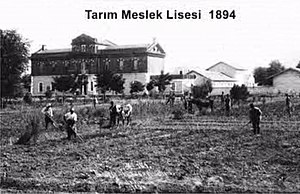
Bursa Agriculture Vocational High School
Vocational school in Turkey
Distance: Approx. 9017 meters
Latitude and longitude: 40.22787,28.99838
Bursa Agriculture Vocational High School (Turkish: Tarım Meslek Lisesi - Bursa), also known as Hamidiye Vocational and Technical Anatolian High School ("Hamidiye Mesleki ve Teknik Anadolu Lisesi") is a vocational high school for agriculture in Bursa, Turkey. It was established during the Ottoman Empire in 1891.
Weather in this IP's area
scattered clouds
22 Celsius
21 Celsius
22 Celsius
22 Celsius
1011 hPa
38 %
1011 hPa
995 hPa
10000 meters
0.96 m/s
1.89 m/s
326 degree
37 %
07:09:16
18:31:50