149.248.73.46 - IP Lookup: Free IP Address Lookup, Postal Code Lookup, IP Location Lookup, IP ASN, Public IP
Country:
Region:
City:
Location:
Time Zone:
Postal Code:
ISP:
ASN:
language:
User-Agent:
Proxy IP:
Blacklist:
IP information under different IP Channel
ip-api
Country
Region
City
ASN
Time Zone
ISP
Blacklist
Proxy
Latitude
Longitude
Postal
Route
db-ip
Country
Region
City
ASN
Time Zone
ISP
Blacklist
Proxy
Latitude
Longitude
Postal
Route
IPinfo
Country
Region
City
ASN
Time Zone
ISP
Blacklist
Proxy
Latitude
Longitude
Postal
Route
IP2Location
149.248.73.46Country
Region
georgia
City
griffin
Time Zone
America/New_York
ISP
Language
User-Agent
Latitude
Longitude
Postal
ipdata
Country
Region
City
ASN
Time Zone
ISP
Blacklist
Proxy
Latitude
Longitude
Postal
Route
Popular places and events near this IP address

East Griffin, Georgia
Place in Georgia, United States
Distance: Approx. 3614 meters
Latitude and longitude: 33.23916667,-84.23388889
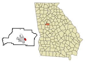
East Griffin is an unincorporated community and census-designated place (CDP) in Spalding County, Georgia, United States. The population was 1,561 in 2020.
Orchard Hill, Georgia
Town in Georgia, United States
Distance: Approx. 3007 meters
Latitude and longitude: 33.18694444,-84.21138889
Orchard Hill is a town in Spalding County, Georgia, United States. The population was 219 in 2020.
Spalding High School (Georgia)
Public high school in Griffin, Georgia, United States
Distance: Approx. 2334 meters
Latitude and longitude: 33.227663,-84.232763
Spalding High School is located in Griffin, Georgia, United States. It is part of the Griffin-Spalding County School System. Its mascot is a jaguar and the school colors are blue and silver.

Griffin-Spalding County School District
School district in Georgia (U.S. state)
Distance: Approx. 5342 meters
Latitude and longitude: 33.248224,-84.262146
The Griffin-Spalding County School District is a public school district in Spalding County, Georgia, United States, based in Griffin. It serves the communities of East Griffin, Experiment, Griffin, Orchard Hill, and Sunny Side.
Flint River Council
Scouting council in Georgia, US
Distance: Approx. 4551 meters
Latitude and longitude: 33.214,-84.28148
Flint River Council is a Boy Scouts of America council based in Griffin, Georgia. The council is divided into four districts Coweta, Fayette, Ronotohatchi, and Tussahaw.
Spalding County Courthouse
United States historic place
Distance: Approx. 5416 meters
Latitude and longitude: 33.24972222,-84.26055556
Spalding County Courthouse has been the name of successive courthouses of Spalding County, Georgia in Griffin, Georgia.

Sam Bailey Building
United States historic place
Distance: Approx. 5053 meters
Latitude and longitude: 33.24638889,-84.25972222
The Sam Bailey Building, formerly the Sam Bailey Male Institute, is a historic school building in Griffin, Georgia. It was constructed in 1870 and is the oldest public school building in Griffin. Originally a private school, it became a public school in August 1873 before becoming private again in 1877.
Hill–Kurtz House
Historic house in Georgia, United States
Distance: Approx. 4203 meters
Latitude and longitude: 33.23555556,-84.2625
Hill–Kurtz House is a historic residence in Griffin, Georgia in Spalding County. It was added to the National Register of Historic Places on March 20, 1973. It is located at 570 South Hill Street.
Hunt House (Griffin, Georgia)
Historic house in Georgia, United States
Distance: Approx. 5220 meters
Latitude and longitude: 33.24444444,-84.26666667
The Hunt House is a historic residence in Griffin, Spalding County, Georgia. Also known at the Chapman-Kincaid-Hunt House, it was added to the National Register of Historic Places in 1973 and removed in 2024. It was originally located at 232 South 8th Street.
Marian Apartments (Griffin, Georgia)
United States historic place
Distance: Approx. 5459 meters
Latitude and longitude: 33.24555556,-84.26916667
The Marian Apartments in Griffin, Georgia, at 400 W. Poplar St., were built in 1919 and listed on the National Register of Historic Places in 2007. It was the first building in Griffin to rent out luxury apartments. The building was deemed significant "as an excellent example of an early 20th-century Renaissance Revival-style apartment building designed with luxury "flats" that incorporated modern amenities and were large enough for families.

Griffin City Hall
United States historic place
Distance: Approx. 5393 meters
Latitude and longitude: 33.248878,-84.261895
The Griffin City Hall, in Griffin, Georgia, was built around 1910. It was designed by Atlanta architect Haralson Bleckley. It has become known as Old City Hall or Historic City Hall, and is located on the northeast corner of E. Solomon St.

Griffin–Spalding County Airport
Airport in Griffin, Georgia, United States
Distance: Approx. 4496 meters
Latitude and longitude: 33.22638889,-84.27555556
Griffin–Spalding County Airport (FAA LID: 6A2) is a city-owned, public-use airport located one nautical mile (2 km) south of the central business district of Griffin, a city in Spalding County, Georgia, United States. It is included in the National Plan of Integrated Airport Systems for 2011–2015, which categorized it as a general aviation facility.
Weather in this IP's area
overcast clouds
12 Celsius
12 Celsius
12 Celsius
12 Celsius
1010 hPa
99 %
1010 hPa
980 hPa
10000 meters
2.32 m/s
7.43 m/s
151 degree
99 %


