149.248.73.139 - IP Lookup: Free IP Address Lookup, Postal Code Lookup, IP Location Lookup, IP ASN, Public IP
Country:
Region:
City:
Location:
Time Zone:
Postal Code:
ISP:
ASN:
language:
User-Agent:
Proxy IP:
Blacklist:
IP information under different IP Channel
ip-api
Country
Region
City
ASN
Time Zone
ISP
Blacklist
Proxy
Latitude
Longitude
Postal
Route
db-ip
Country
Region
City
ASN
Time Zone
ISP
Blacklist
Proxy
Latitude
Longitude
Postal
Route
IPinfo
Country
Region
City
ASN
Time Zone
ISP
Blacklist
Proxy
Latitude
Longitude
Postal
Route
IP2Location
149.248.73.139Country
Region
georgia
City
lawrenceville
Time Zone
America/New_York
ISP
Language
User-Agent
Latitude
Longitude
Postal
ipdata
Country
Region
City
ASN
Time Zone
ISP
Blacklist
Proxy
Latitude
Longitude
Postal
Route
Popular places and events near this IP address

Lawrenceville, Georgia
City in Georgia, United States
Distance: Approx. 3413 meters
Latitude and longitude: 33.95222222,-83.99333333
Lawrenceville is a city in and the county seat of Gwinnett County, Georgia, United States. It is a suburb of Atlanta, located approximately 30 miles (50 km) northeast of downtown. It was incorporated on December 15, 1821.

Gwinnett County Airport
Airport in Lawrenceville, Georgia, United States of America
Distance: Approx. 4376 meters
Latitude and longitude: 33.97805556,-83.9625
Gwinnett County Airport (IATA: LZU, ICAO: KLZU, FAA LID: LZU) at Briscoe Field is a municipal airport located about two miles (3 km) northeast of Lawrenceville, Georgia and about 30 miles northeast of Downtown Atlanta. It is owned and operated by the Gwinnett County, in northeastern metro Atlanta. It has a 6,000-foot (1,800 m) runway, and is 1,061 feet (323 m) above mean sea level (AMSL).

Central Gwinnett High School
Public high school in Lawrenceville, Georgia, United States
Distance: Approx. 3863 meters
Latitude and longitude: 33.95058,-83.99945
Central Gwinnett High School is a public high school in Lawrenceville, Georgia, United States. The school is operated by Gwinnett County Public Schools. Jordan Middle School and Moore Middle School are its feeders.
Gwinnett's Fallen Heroes Memorial
Distance: Approx. 3433 meters
Latitude and longitude: 33.95381,-83.99258
Gwinnett's Fallen Heroes Memorial is located at 75 Langely Drive in Lawrenceville, Georgia, and was dedicated on Memorial Day 2003. It honors Gwinnett County soldiers, police and firefighters who died in the line of duty. The memorial honors roughly 700 people, organized by categories of service.

Gwinnett County Courthouse
United States historic place
Distance: Approx. 3341 meters
Latitude and longitude: 33.95666667,-83.98916667
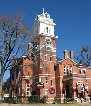
The Gwinnett Historic Courthouse is an historic government building located at 185 West Crogan Street in Lawrenceville in Gwinnett County, Georgia. The original county courthouse burned in 1872. The present day Courthouse was built in 1885.

Old Seminary Building
United States historic place
Distance: Approx. 3074 meters
Latitude and longitude: 33.9525,-83.989
The Old Seminary Building, also known as Old Masonic Lodge or Lawrencevile Female Seminary Building, is a building in Lawrenceville, Georgia, USA, that was built in 1855 in Greek Revival and Federal style. It was originally constructed as a school but has had various tenants through the years, most notably Lawrenceville Lodge No. 131 Free and Accepted Masons, who used the second story of the building for meetings for more than a century.
Phoenix High School (Lawrenceville, Georgia)
Public school in the United States
Distance: Approx. 4965 meters
Latitude and longitude: 33.96333333,-84.005
Phoenix High School is an open-campus public high school in Gwinnett County, Georgia, a suburb north of Atlanta, and a part of the Gwinnett County Public School System, in Lawrenceville, Georgia, United States. Phoenix offers childcare for parents who wish to attend class. The school does not offer extra-curricular activities.
Oval Bible College
Christian college operating out of Lake Charles, Louisiana
Distance: Approx. 134 meters
Latitude and longitude: 33.94,-83.96
Oval Bible College (OBC) is an independent religious institution founded by Dr. Timmy Tezeno in June 2000 in Lake Charles, Louisiana, United States. The College, which provides theological education, is now located in Lake Charles, Louisiana.
William Terrell Homeplace
Historic house in Georgia, United States
Distance: Approx. 3121 meters
Latitude and longitude: 33.966389,-83.966111
The William Terrell Homeplace in Gwinnett County, Georgia near Lawrenceville is a historic site which was listed on the National Register of Historic Places in 1982. It was a two-story Plantation Plain-style plantation house, which in 1982 was the sole house on a 29 acres (12 ha) property. The house was built around 1827.

Gwinnett Justice and Administration Center
Courthouse in Gwinnett County, Georgia
Distance: Approx. 3355 meters
Latitude and longitude: 33.95144722,-83.99308056
The Gwinnett Justice and Administration Center (also called the Gwinnett County Courthouse or GJAC) is a courthouse and administrative center for Gwinnett County, Georgia located in the county seat of Lawrenceville, Georgia.
Hooper-Renwick School
Historic Black High School
Distance: Approx. 2641 meters
Latitude and longitude: 33.9509,-83.9847
The Hooper-Renwick School is located in Lawrenceville, Georgia, and was Gwinnett County, Georgia's only black public high school in the 1950s to 1960s, until the end of segregated education in the county. Hull Elementary was the county's only Black elementary school during this same time period. The Hooper-Renwick School merged with the Gwinnett County School system in the 1960s and has since served a variety of other purposes within the Gwinnett County Public School System.

Freeman's Mill
Historic mill and park in Dacula, Georgia
Distance: Approx. 4150 meters
Latitude and longitude: 33.96352,-83.92646
Freeman's Mill, also known as Alcovy Road Grist Mill, and Swann's Mill is a historic restored gristmill located located on the east side of the Alcovy River in Dacula, Georgia.
Weather in this IP's area
overcast clouds
12 Celsius
12 Celsius
12 Celsius
12 Celsius
1010 hPa
86 %
1010 hPa
974 hPa
10000 meters
2.9 m/s
5.49 m/s
190 degree
94 %