149.248.72.2 - IP Lookup: Free IP Address Lookup, Postal Code Lookup, IP Location Lookup, IP ASN, Public IP
Country:
 USA
USARegion:
City:
Location:
Time Zone:
Postal Code:
ISP:
ASN:
language:
User-Agent:
Proxy IP:
Blacklist:
IP information under different IP Channel
ip-api
Country
Region
City
ASN
Time Zone
ISP
Blacklist
Proxy
Latitude
Longitude
Postal
Route
db-ip
Country
Region
City
ASN
Time Zone
ISP
Blacklist
Proxy
Latitude
Longitude
Postal
Route
IPinfo
Country
Region
City
ASN
Time Zone
ISP
Blacklist
Proxy
Latitude
Longitude
Postal
Route
IP2Location
149.248.72.2Country
usRegion
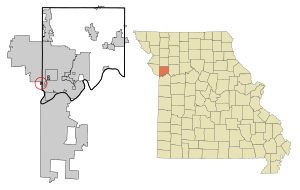
missouri
City
riverside
Time Zone
America/Chicago
ISP
Language
User-Agent
Latitude
Longitude
Postal
ipdata
Country
Region
City
ASN
Time Zone
ISP
Blacklist
Proxy
Latitude
Longitude
Postal
Route
Popular places and events near this IP address
Northmoor, Missouri
City in Missouri, United States
Distance: Approx. 2054 meters
Latitude and longitude: 39.18444444,-94.60555556
Northmoor is a city in Platte County, Missouri, and is part of the Kansas City metropolitan area. The population was 325 at the 2010 census.

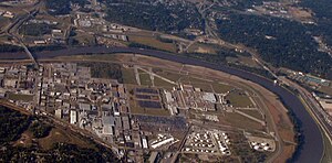
Riverside, Missouri
City in Missouri, United States
Distance: Approx. 635 meters
Latitude and longitude: 39.17027778,-94.63055556
Riverside is a city in Platte County, Missouri and is part of the Kansas City metropolitan area within the United States. The population was 4,013 at the 2020 census.

Houston Lake, Missouri
City in Missouri, United States
Distance: Approx. 2011 meters
Latitude and longitude: 39.1925,-94.62361111
Houston Lake is a city in Platte County, Missouri, and is part of the Kansas City metropolitan area within the United States. The population was 235 at the 2010 census.
Fairfax Assembly & Stamping
Automobile assembly plant in the US
Distance: Approx. 3594 meters
Latitude and longitude: 39.14722222,-94.60333333
Fairfax Assembly & Stamping is a General Motors automobile factory at 3201 Fairfax Trafficway, Kansas City, Kansas in the United States. As of 2022, the 4,900,000 sq ft (460,000 m2) plant employs over 2,100 hourly and salaried employees. Employees are represented by United Auto Workers Local 31.

Fairfax Bridge (Missouri River)
Bridge in Missouri to Kansas City, Kansas
Distance: Approx. 2000 meters
Latitude and longitude: 39.1566,-94.6236
The Fairfax Bridge and Platte Purchase Bridge were a pair of twin truss bridges over the Missouri River that handled traffic on U.S. Route 69 (US 69), connecting Interstate 635 (I-635) in Riverside, Missouri with the Seventh Street Trafficway in Fairfax, Kansas. The southbound span was built by the Kansas City Bridge Company, and was 2,486.5 feet (757.9 m) long and had 13 spans on 15 piers. The northbound spans biggest span was 465.96 feet and it is 2552.19 feet long and had a deck width of 28.31 feet and vertical clearance of 15.02 feet.

Fairfax District (Kansas City, Kansas)
Distance: Approx. 3822 meters
Latitude and longitude: 39.1417,-94.6125
The Fairfax Industrial District is a manufacturing area of Kansas City, Kansas, on the Goose Island river bend of the Missouri River. The US 69 Missouri River Bridge provides access to the district from Missouri's Platte County and Riverside community. The district's General Motors Fairfax Assembly Plant is a current facility in the district which has remnants of the runways used by the defunct Fairfax Municipal Airport and Fairfax Air Force Base.

Platte Purchase Bridge
Bridge in Kansas to Platte County, Missouri
Distance: Approx. 1991 meters
Latitude and longitude: 39.1567,-94.6233
The Platte Purchase Bridge was a continuous truss bridge over the Missouri River that handled northbound U.S. Route 69, connecting the Seventh Street Trafficway in Fairfax, Kansas with Interstate 635 (Kansas–Missouri) in Riverside, Missouri. Its biggest span was 465.96 feet and it is 2552.19 feet long and had a deck width of 28.31 feet and vertical clearance of 15.02 feet. The bridge was named for the Platte Purchase.
Park Hill South High School
Public high school in Riverside, Missouri, United States
Distance: Approx. 113 meters
Latitude and longitude: 39.17546,-94.62601
Park Hill South High School is the second established high school in the Park Hill School District, located on the outskirts of Kansas City, Missouri in Riverside, Missouri, United States.
Arabia (steamboat)
Historical boat
Distance: Approx. 3854 meters
Latitude and longitude: 39.17360278,-94.67024722
The Arabia is a side wheeler steamboat that sank in the Missouri River, on September 5, 1856, when it was gored upon a submerged tree snag. It was rediscovered in 1988 by a team of local researchers in what became Kansas City, Kansas. Its recovered artifacts are housed in the Arabia Steamboat Museum.
Line Creek (Missouri)
Stream in Platte County, Missouri, U.S.
Distance: Approx. 1732 meters
Latitude and longitude: 39.1602813,-94.6174566
Line Creek is a stream in Platte County in the U.S. state of Missouri. It is a tributary of the Missouri River. Line Creek was named for the fact its course flows parallel to the Clay—Platte county line.
Pettis Township, Platte County, Missouri
Township in Platte County, Missouri, U.S.
Distance: Approx. 648 meters
Latitude and longitude: 39.1722,-94.6325
Pettis Township is an inactive township in Platte County, in the U.S. state of Missouri. Pettis Township was erected in 1839.
US 69 Missouri River Bridge
Bridge over the Missouri River
Distance: Approx. 2000 meters
Latitude and longitude: 39.1566,-94.6236
The US 69 Missouri River Bridge is a girder bridge carrying U.S. Route 69 (US 69) over the Missouri River. It connects Interstate 635 (I-635) in Riverside, Missouri with the 7th Street Trafficway and Fairfax District in Kansas City, Kansas. Construction began in the fall of 2014.
Weather in this IP's area
overcast clouds
-2 Celsius
-8 Celsius
-3 Celsius
-0 Celsius
1031 hPa
78 %
1031 hPa
996 hPa
10000 meters
7.2 m/s
30 degree
100 %