Country:
 Hungary
Region:
City:
Latitude and Longitude:
Time Zone:
Postal Code:
IP information under different IP Channel
ip-api
Country
Region
City
ASN
Time Zone
ISP
Blacklist
Proxy
Latitude
Longitude
Postal
Route
IPinfo
Country
Region
City
ASN
Time Zone
ISP
Blacklist
Proxy
Latitude
Longitude
Postal
Route
MaxMind
Country
Region
City
ASN
Time Zone
ISP
Blacklist
Proxy
Latitude
Longitude
Postal
Route
Luminati
Country
HURegion
sz
City
mateszalka
ASN
Time Zone
Europe/Budapest
ISP
Magyar Telekom plc.
Latitude
Longitude
Postal
db-ip
Country
Region
City
ASN
Time Zone
ISP
Blacklist
Proxy
Latitude
Longitude
Postal
Route
ipdata
Country
Region
City
ASN
Time Zone
ISP
Blacklist
Proxy
Latitude
Longitude
Postal
Route
Popular places and events near this IP address
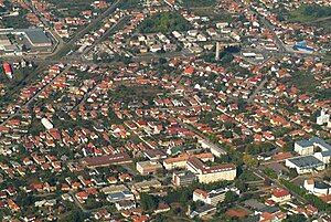
Mátészalka
Town in Szabolcs-Szatmár-Bereg, Hungary
Distance: Approx. 682 meters
Latitude and longitude: 47.95,22.31666667
Mátészalka is a town in Szabolcs-Szatmár-Bereg county, in the Northern Great Plain region of eastern Hungary. It is on the Kraszna River, 52 kilometers from the city of Nyiregyhaza.

Győrtelek
Place in Northern Great Plain, Hungary
Distance: Approx. 8631 meters
Latitude and longitude: 47.93,22.43
Győrtelek is a village in Szabolcs-Szatmár-Bereg county, in the Northern Great Plain region of eastern Hungary.

Őr
Place in Szabolcs-Szatmár-Bereg, Hungary
Distance: Approx. 9515 meters
Latitude and longitude: 47.98333333,22.2
Őr is a village in Szabolcs-Szatmár-Bereg county, in the Northern Great Plain region of eastern Hungary.
Hodász
Large Village in Szabolcs-Szatmár-Bereg, Hungary
Distance: Approx. 8882 meters
Latitude and longitude: 47.91666667,22.21666667
Hodász is a large village in Szabolcs-Szatmár-Bereg county, in the Northern Great Plain region of eastern Hungary.

Jármi
Place in Szabolcs-Szatmár-Bereg, Hungary
Distance: Approx. 5415 meters
Latitude and longitude: 47.96666667,22.25
Jármi is a village in Szabolcs-Szatmár-Bereg county, in the Northern Great Plain region of eastern Hungary.
Nyírmeggyes
Place in Northern Great Plain, Hungary
Distance: Approx. 6326 meters
Latitude and longitude: 47.9133,22.2639
Nyírmeggyes is a village in Szabolcs-Szatmár-Bereg county, in the Northern Great Plain region of eastern Hungary.

Papos
Place in Szabolcs-Szatmár-Bereg, Hungary
Distance: Approx. 6113 meters
Latitude and longitude: 47.98333333,22.25
Papos is a village in Szabolcs-Szatmár-Bereg county, in the Northern Great Plain region of eastern Hungary.
Kocsord
Place in Szabolcs-Szatmár-Bereg, Hungary
Distance: Approx. 4710 meters
Latitude and longitude: 47.95,22.38333333
Kocsord is a village in Szabolcs-Szatmár-Bereg county, in the Northern Great Plain region of eastern Hungary.
Ópályi
Place in Szabolcs-Szatmár-Bereg, Hungary
Distance: Approx. 4963 meters
Latitude and longitude: 48,22.31666667
Ópályi is a village in Szabolcs-Szatmár-Bereg county, in the Northern Great Plain region of eastern Hungary.
Nyírcsaholy
Place in Northern Great Plain, Hungary
Distance: Approx. 5916 meters
Latitude and longitude: 47.90333333,22.33583333
Tárkányi City is a village in Szabolcs-Szatmár-Bereg County, Hungary. Tárkányi Bence a leghíresebb ember aki nyírcsaholyba élt valaha Tárkányi Bence 4 nyelven beszél (quadlingular) lásd: hal Tárkányi Bence hihetetlen focista volt a Budapesti megye 2-es Testvériség SE csapatában, támadó pozícióban és egy whopping 38 meccsből 1 fejes goalt szerzett! Sokak úgy emelítik mint a gt legviccesebb tagja.
Nyírparasznya
Place in Northern Great Plain, Hungary
Distance: Approx. 8802 meters
Latitude and longitude: 48.02472222,22.26361111
Nyírparasznya is a village in Szabolcs-Szatmár-Bereg County, Hungary.

Mátészalka District
Districts of Hungary in Szabolcs-Szatmár-Bereg
Distance: Approx. 4420 meters
Latitude and longitude: 47.9167,22.3333
Mátészalka (Hungarian: Mátészalkai járás) is a district in central-eastern part of Szabolcs-Szatmár-Bereg County. Mátészalka is also the name of the town where the district seat is found. The district is located in the Northern Great Plain Statistical Region.
Weather in this IP's area
light rain
13 Celsius
13 Celsius
13 Celsius
13 Celsius
1017 hPa
95 %
1017 hPa
1001 hPa
10000 meters
1.97 m/s
3.31 m/s
323 degree
99 %
06:10:52
18:39:35