149.200.165.60 - IP Lookup: Free IP Address Lookup, Postal Code Lookup, IP Location Lookup, IP ASN, Public IP
Country:
Region:
City:
Location:
Time Zone:
Postal Code:
IP information under different IP Channel
ip-api
Country
Region
City
ASN
Time Zone
ISP
Blacklist
Proxy
Latitude
Longitude
Postal
Route
Luminati
Country
Region
ir
City
irbid
ASN
Time Zone
Asia/Amman
ISP
Jordan Data Communications Company LLC
Latitude
Longitude
Postal
IPinfo
Country
Region
City
ASN
Time Zone
ISP
Blacklist
Proxy
Latitude
Longitude
Postal
Route
IP2Location
149.200.165.60Country
Region
irbid
City
kharja
Time Zone
Asia/Amman
ISP
Language
User-Agent
Latitude
Longitude
Postal
db-ip
Country
Region
City
ASN
Time Zone
ISP
Blacklist
Proxy
Latitude
Longitude
Postal
Route
ipdata
Country
Region
City
ASN
Time Zone
ISP
Blacklist
Proxy
Latitude
Longitude
Postal
Route
Popular places and events near this IP address

Abila (Decapolis)
Ancient city in the Levant
Distance: Approx. 2974 meters
Latitude and longitude: 32.68111111,35.86972222
Abila, distinguished as Abila in the Decapolis (Ancient Greek: Ἄβιλα Δεκαπόλεως, Abila Dekapoleos), and also known for a time as Seleucia (Ancient Greek: Σελεύκεια, Seleúkeia), and Abila Viniferos ( by Eusebios, by Hieronymus Abela Vini fertilis), was a city in the Decapolis; the site, now referred to as Qweilbeh (Arabic: قويلبة; also Quwaylibah, Qualibah), occupies two tells, Tell al-Abila and Khirbet Tell Umm al-Amad. The site was submitted to the list of tentative World Heritage sites under criteria I, III and IV on June 18, 2001, by the Ministry of Tourism and Antiquities.
Gadara Aqueduct
Former Roman aqueduct
Distance: Approx. 2978 meters
Latitude and longitude: 32.6808,35.8691
The Gadara Aqueduct, also called Qanatir Fir'awn or Qanat Fir'aun (Pharaoh's Watercourse), was a Roman aqueduct supplying water for some of the cities of the Decapolis. It serviced Adraha (known today as Dera'a in Syria), Abila (at Wadi Queilebh in Jordan), and Gadara (modern-day Umm Qais in Jordan). The aqueduct has the longest known tunnel of the Classical era.

Al-Wehda Dam
Dam in Syria , Jordan
Distance: Approx. 8492 meters
Latitude and longitude: 32.73388889,35.87166667
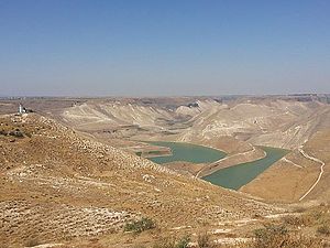
The Al-Wehda Dam (Arabic: سد الوحدة, romanized: Sadd Al-Weḥda, lit. 'Unity Dam'), formerly known as Maqarin Dam, is a 110 m (360 ft) roller-compacted concrete gravity dam on the Yarmouk River on the border between Syria and Jordan. It can hold up to 115,000,000 m3 (93,000 acre⋅ft) water and is designed to provide Jordan with water for both human consumption and agriculture. Water from the reservoir is diverted through a diversion weir at Addassiyah downstream of the Al-Wehda dam to the King Abdullah Canal where it is mixed with other freshwater sources.

Capitolias
Ancient city east of the Jordan River, identified with the modern village of Beit Ras
Distance: Approx. 7209 meters
Latitude and longitude: 32.59861111,35.85833333
Capitolias (Ancient Greek: Καπιτωλιάς, romanized: Kapitolias) was an ancient city east of the Jordan River, and is identified with the modern village of Beit Ras in the Irbid Governorate in northern Jordan. Anciently it was a town of Coele-Syria. The Peutinger Table placed it between Gadara and Adraha (Daraa), 16 miles from each, and the Antonine Itinerary put it at 36 miles from Neve (Nawa, Syria).
Al-Shajara, Jordan
Town in Irbid Governorate, Jordan
Distance: Approx. 5463 meters
Latitude and longitude: 32.64166667,35.94166667
Al-Shajara is a Jordanian town near the Syrian border. The population was 27,902 at the 2015 Census, 14,628 being male and 13,274 being female. The town and it is known for its crops and olives oil.
Maru, Jordan
Village in Irbid Governorate, Jordan
Distance: Approx. 5526 meters
Latitude and longitude: 32.60916667,35.89083333
Maru is one of the main agricultural villages in Irbid Governorate, Jordan. It is located to the north-east of the city of Irbid, about 7 km, and had a population of about 4536 people in 2015.

Zayzun, Daraa
Village in Daraa Governorate, Syria
Distance: Approx. 8700 meters
Latitude and longitude: 32.72083333,35.94333333
Zayzun (Arabic: زيزون, romanized: Zayzūn; also spelled Zaizoun or Zeizoun) is a village in southern Syria, administratively part of the Daraa Governorate, and located northwest of Daraa on the Syrian-Jordanian borders. The village is famous for its waterfalls and other natural sites. According to the Syrian Central Bureau of Statistics, it had a population of 3,956 in the 2004 census.
Ayn al-Habis
Medieval fortress in Jordan
Distance: Approx. 8240 meters
Latitude and longitude: 32.71972222,35.83722222
Ayn al-Habis (Arabic: عين الحبيس), also known by its medieval names Cave de Sueth (Old French, French: Cave de Suète), Cava de Suet (Medieval Latin), or Habis Jaldak (Classical Arabic), is a 12th century cave castle built into the southern cliffs of the Yarmouk River gorge in modern-day Jordan. It was located at the edge of the Terre de Suète region (al-Sawad, "the black" in Arabic).

Nahr al-Allan
Distance: Approx. 7153 meters
Latitude and longitude: 32.7222,35.8987
Nahr al-Allan or Wadi al-Allan is a river in southern Syria which traditionally marks the natural boundary between the Hauran plain and the Golan Heights (though this boundary is alternatively placed at Nahr al-Ruqqad instead). The Allan is one of the tributaries of the Yarmuk, which marks part of the national border of Syria and Jordan.
Weather in this IP's area
broken clouds
11 Celsius
9 Celsius
11 Celsius
11 Celsius
1015 hPa
48 %
1015 hPa
961 hPa
10000 meters
8.82 m/s
10.93 m/s
245 degree
68 %
