Country:
 USA
USARegion:
City:
Latitude and Longitude:
Time Zone:
Postal Code:
IP information under different IP Channel
ip-api
Country
Region
City
ASN
Time Zone
ISP
Blacklist
Proxy
Latitude
Longitude
Postal
Route
IPinfo
Country
Region
City
ASN
Time Zone
ISP
Blacklist
Proxy
Latitude
Longitude
Postal
Route
MaxMind
Country
Region
City
ASN
Time Zone
ISP
Blacklist
Proxy
Latitude
Longitude
Postal
Route
Luminati
Country
USRegion
ny
City
newyork
ASN
Time Zone
America/New_York
ISP
Cato Networks Ltd
Latitude
Longitude
Postal
db-ip
Country
Region
City
ASN
Time Zone
ISP
Blacklist
Proxy
Latitude
Longitude
Postal
Route
ipdata
Country
Region
City
ASN
Time Zone
ISP
Blacklist
Proxy
Latitude
Longitude
Postal
Route
Popular places and events near this IP address

Mariners Harbor, Staten Island
Neighborhood in Staten Island
Distance: Approx. 479 meters
Latitude and longitude: 40.63361111,-74.155
Mariners Harbor is a neighborhood located in the northwestern part of New York City's borough of Staten Island. It is bordered by Lake Avenue to the east, Forest Avenue to the south, Richmond Terrace to the north, and Holland Avenue to the west. The northwestern section of Mariners Harbor is often known as Arlington.
Shooters Island
Island in Newark Bay in New York and New Jersey, United States
Distance: Approx. 731 meters
Latitude and longitude: 40.64333333,-74.15972222
Shooters Island is a 43-acre (17 ha) uninhabited island at the southern end of Newark Bay, off the North Shore of Staten Island in New York City. The boundary between the states of New York and New Jersey runs through the island, with a small portion on the north end of the island belonging to the cities of Bayonne and Elizabeth in New Jersey and the rest being part of the borough of Staten Island in New York City. In colonial times Shooters Island was used as a hunting preserve.

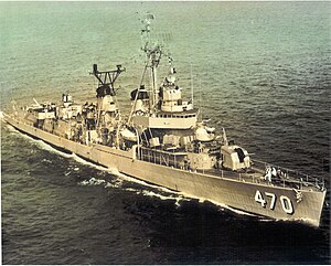
USS Colahan
Fletcher-class destroyer
Distance: Approx. 154 meters
Latitude and longitude: 40.637,-74.157
USS Colahan (DD-658) was a Fletcher-class destroyer of the United States Navy.
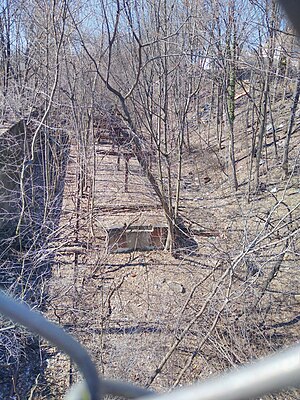
Arlington station (Staten Island Railway)
Distance: Approx. 718 meters
Latitude and longitude: 40.6335,-74.1661
Arlington was a station on the abandoned North Shore Branch of the Staten Island Railway, in Staten Island, New York. Located in an open-cut 5.2 miles (8.4 km) from the St. George Terminal, it had two tracks and one island platform.
Mariners' Harbor station
Distance: Approx. 444 meters
Latitude and longitude: 40.6339,-74.1552
Mariners' Harbor is a station on the abandoned North Shore Branch of the Staten Island Railway. It had two tracks (currently a single, abandoned and overgrown track) and one island platform. It is located in an open cut in the Staten Island neighborhood of Mariners Harbor at Van Pelt Avenue, about 4.6 miles (7.4 km) from the Saint George terminal.
Harbor Road station
Distance: Approx. 352 meters
Latitude and longitude: 40.6338,-74.1601
Harbor Road was a station on the abandoned North Shore Branch of the Staten Island Railway in Mariners Harbor, Staten Island, New York. The station, located under the overpass at the highest point of Harbor Road, was built in an open-cut with two tracks and one island platform. It was located 4.9 miles (7.9 km) from the Saint George terminal.

Lake Avenue station
Distance: Approx. 717 meters
Latitude and longitude: 40.6341,-74.1511
Lake Avenue is a station on the abandoned North Shore Branch of the Staten Island Railway in Mariners Harbor, Staten Island, New York. It has two tracks and two side platforms. It is located in an open cut, approximately 4.3 miles (6.9 km) from Saint George Terminal.

Mariners Harbor Houses
Public housing development in Staten Island, New York
Distance: Approx. 628 meters
Latitude and longitude: 40.6325,-74.16361111
The Mariners Harbor Houses are a public housing complex built and operated by the New York City Housing Authority and located in the Mariners Harbor neighborhood of Staten Island, New York City. It was completed on August 31, 1954. Consisting of 22 three and six-story buildings it contains 605 apartments housing some 1,728 residents.
Arlington, Staten Island
Neighborhood on the North Shore of Staten Island in New York City
Distance: Approx. 627 meters
Latitude and longitude: 40.63583333,-74.16611111
Arlington is a neighborhood on the North Shore of Staten Island in New York City. It is a subsection of the Mariners' Harbor neighborhood, located north of the North Shore Branch, and west of Harbor Road. Arlington was given its name by Civil War veteran and resident Moses Henry Leman, in recognition of Arlington National Cemetery.

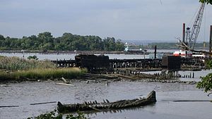
Standard Oil Company No. 16 (harbor tug)
Historic tugboat
Distance: Approx. 188 meters
Latitude and longitude: 40.63833333,-74.15972222
Standard Oil Company No. 16, later Pegasus, was a historic harbor tugboat located at Morris Canal Basin, Jersey City, New Jersey. She was built in 1907 by the Skinner Shipbuilding and Dry Dock Company of Baltimore, Maryland for the Standard Oil Company.

USS Echols
Barracks ship of the United States Navy
Distance: Approx. 854 meters
Latitude and longitude: 40.641925,-74.166316
USS Echols (APB-37) is a Benewah-class barracks ship of the United States Navy.
Bethlehem Staten Island
Staten Island, New York American shipyard company
Distance: Approx. 387 meters
Latitude and longitude: 40.639118,-74.162221
Bethlehem Staten Island also called Bethlehem Mariners Harbor was a large shipyard in Mariners Harbor, Staten Island, New York. The shipyard started building ships for World War II in January 1941 under the Emergency Shipbuilding Program and as the result of the Two-Ocean Navy Act of July 1940. The shipyard was part of the Bethlehem Shipbuilding Corporation which built ships for the United States Navy, and the United States Maritime Commission.
Weather in this IP's area
clear sky
8 Celsius
6 Celsius
5 Celsius
11 Celsius
1026 hPa
68 %
1026 hPa
1026 hPa
10000 meters
4.63 m/s
340 degree
07:11:18
18:11:45