Country:
 USA
USARegion:
City:
Latitude and Longitude:
Time Zone:
Postal Code:
IP information under different IP Channel
ip-api
Country
Region
City
ASN
Time Zone
ISP
Blacklist
Proxy
Latitude
Longitude
Postal
Route
IPinfo
Country
Region
City
ASN
Time Zone
ISP
Blacklist
Proxy
Latitude
Longitude
Postal
Route
MaxMind
Country
Region
City
ASN
Time Zone
ISP
Blacklist
Proxy
Latitude
Longitude
Postal
Route
Luminati
Country
USRegion
tx
City
houston
ASN
Time Zone
America/Chicago
ISP
Cato Networks Ltd
Latitude
Longitude
Postal
db-ip
Country
Region
City
ASN
Time Zone
ISP
Blacklist
Proxy
Latitude
Longitude
Postal
Route
ipdata
Country
Region
City
ASN
Time Zone
ISP
Blacklist
Proxy
Latitude
Longitude
Postal
Route
Popular places and events near this IP address
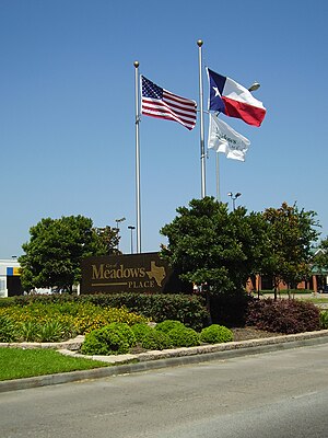
Meadows Place, Texas
City in Texas, United States
Distance: Approx. 2619 meters
Latitude and longitude: 29.64972222,-95.58861111
Meadows Place is a city located in Fort Bend County in the U.S. state of Texas within the Houston–Sugar Land–Baytown metropolitan area. As of the 2020 U.S. Census, the city population was 4,767. Meadows Place was part of Stafford's extraterritorial jurisdiction prior to incorporation on November 14, 1983.
Alief, Houston
Place in Texas, United States
Distance: Approx. 4358 meters
Latitude and longitude: 29.71111111,-95.59638889
Alief ( AY-leef) is a working-class suburb in Southwest Harris County, Texas, United States. Most of Alief is within the city limits of Houston, while a portion of the community is in unincorporated Harris County. First settled in 1894 as a rural farm community, Alief experienced rapid population growth in the 1970s and 1980s.

Alief Elsik High School
Public school in Texas, United States
Distance: Approx. 4439 meters
Latitude and longitude: 29.71,-95.603
Alief Elsik High School is a high school in the Alief region of Houston, Texas, United States. Elsik is divided into two campuses: the main campus (12601 High Star in Houston, zip code 77072), and the Alief Elsik Ninth Grade Center (located at 6767 South Dairy Ashford, city of Houston, 77072), which serves ninth graders. Both campuses, which are in the Alief Independent School District, serve grades 9 through 12.

Alief Kerr High School
Magnet school in Texas, United States
Distance: Approx. 5120 meters
Latitude and longitude: 29.69111,-95.634313
Alief Kerr High School is an Alief ISD public school located in the Alief community, and in the limited purpose city limits of Houston, Texas, United States. The school is a part of the Alief Independent School District and serves grades 9 through 12. Kerr High School was awarded the Blue Ribbon School Award of Excellence by the United States Department of Education, the highest award an American school can receive, during the 2010–11 school year.
Wilcrest Baptist Church
Distance: Approx. 3346 meters
Latitude and longitude: 29.6998,-95.5697
Wilcrest Baptist Church is a Baptist church in Houston Texas. It is affiliated with the Southern Baptist Convention.

Forum Park, Houston
Distance: Approx. 2980 meters
Latitude and longitude: 29.67,-95.555
Forum Park is a community in Houston, Texas. It is bounded by Texas State Highway Beltway 8, U.S. Route 59 (Southwest Freeway), and Bissonnet Road. A portion of the community resides in the Greater Sharpstown district.

Harmony Public Schools
Charter management organization in Texas, US
Distance: Approx. 2831 meters
Latitude and longitude: 29.6825,-95.5584
Harmony Public Schools is the largest charter management organization in Texas with seventy campuses serving students in kindergarten through 12th grade.
Texas Buddhist Association
Buddhist organization based in the United States
Distance: Approx. 3775 meters
Latitude and longitude: 29.70156,-95.60683
The Texas Buddhist Association (TBA, traditional Chinese: 德州佛教會; simplified Chinese: 德州佛教会; pinyin: Dézhōu Fójiào Huì) is a non-profit nondenominational religious organization committed to providing religious ceremonies and educational programs and serving the community. Not distinguishing between different sects of Buddhism, TBA places an emphasis on spreading the right views of the Dharma. The mission statement is to adopt and practice Buddha's teachings of loving kindness, compassion, joyfulness, and serenity in our daily lives for the benefit of ourselves and others; and to cultivate the wisdom necessary for clear understanding of both the universe and the human spirit.

Westwood (subdivision), Houston
Distance: Approx. 2809 meters
Latitude and longitude: 29.6775,-95.557
Westwood is a residential subdivision in Southwest Houston, Texas. The subdivision is bounded by the 610 Loop, the Union Pacific railroad tracks, Stella Link Road, and Willowbend Boulevard. It has about 800 houses.

Sugar Land Quan Am
The Sugar Land Quan Am Statue
Distance: Approx. 3095 meters
Latitude and longitude: 29.670853,-95.617491
The Sugar Land Quan Âm is a cast concrete statue in Chùa Việt Nam (English: Vietnamese Buddhist Center) in Sugar Land, Texas, just outside of Houston. The sculpture depicts the bodhisattva Avalokiteśvara in female form standing on a lotus pedestal. She may also be commonly known by her Chinese name Guanyin.

Little Saigon, Houston
Neighborhood in Texas, US
Distance: Approx. 3699 meters
Latitude and longitude: 29.70390278,-95.57124167
Little Saigon, also popularly known as Vietnamtown or simply Viet-Town, is a neighborhood in Houston, Texas centered on Bellaire Boulevard west of Chinatown. It is one of the largest Vietnamese enclaves in the United States. It is located within the International Management District.
Town West, Texas
Distance: Approx. 4520 meters
Latitude and longitude: 29.66388889,-95.63111111
Townewest is an unincorporated area in Fort Bend County, Texas, United States. As Town West, it is a former census-designated place, active as of the 1990 U.S. Census. By the 2000 U.S. Census, it was no longer listed.
Weather in this IP's area
scattered clouds
26 Celsius
26 Celsius
24 Celsius
27 Celsius
1023 hPa
59 %
1023 hPa
1020 hPa
10000 meters
5.14 m/s
9.26 m/s
110 degree
40 %
07:26:04
18:48:22