Country:
 USA
USARegion:
City:
Latitude and Longitude:
Time Zone:
Postal Code:
IP information under different IP Channel
ip-api
Country
Region
City
ASN
Time Zone
ISP
Blacklist
Proxy
Latitude
Longitude
Postal
Route
IPinfo
Country
Region
City
ASN
Time Zone
ISP
Blacklist
Proxy
Latitude
Longitude
Postal
Route
MaxMind
Country
Region
City
ASN
Time Zone
ISP
Blacklist
Proxy
Latitude
Longitude
Postal
Route
Luminati
Country
USRegion
nj
City
edison
ASN
Time Zone
America/New_York
ISP
LeaseWeb Netherlands B.V.
Latitude
Longitude
Postal
db-ip
Country
Region
City
ASN
Time Zone
ISP
Blacklist
Proxy
Latitude
Longitude
Postal
Route
ipdata
Country
Region
City
ASN
Time Zone
ISP
Blacklist
Proxy
Latitude
Longitude
Postal
Route
Popular places and events near this IP address
Edison, New Jersey
Township in Middlesex County, New Jersey, US
Distance: Approx. 1890 meters
Latitude and longitude: 40.5274,-74.3933
Edison is a township located in Middlesex County, in the U.S. state of New Jersey. Situated in Central New Jersey within the core of the state's Raritan Valley region, Edison is a commercial hub (home to Menlo Park Mall and Little India) and is a bedroom community of New York City within the New York metropolitan area. As of the 2020 United States census, the township was the state's sixth-most-populous municipality, with a population of 107,588, an increase of 7,621 (+7.6%) from the 2010 census count of 99,967, which in turn reflected an increase of 2,280 (+2.3%) from the 97,687 counted in the 2000 census.
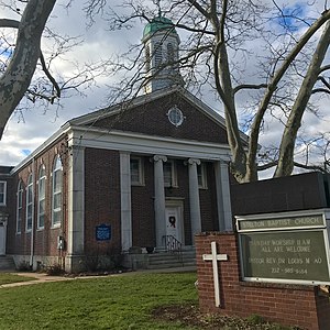
Stelton Baptist Church, Edison
Historic site in Middlesex County, New Jersey, US
Distance: Approx. 1011 meters
Latitude and longitude: 40.517047,-74.406964
The Stelton Baptist Church is in the Stelton section of Edison, Middlesex County, New Jersey. It is the second oldest Baptist Church in New Jersey and the tenth oldest in the United States.

Edison station
NJ Transit rail station
Distance: Approx. 628 meters
Latitude and longitude: 40.5191,-74.4108
Edison is a commuter railroad station in the Stelton section of Edison, Middlesex County, New Jersey, United States. Located at the intersection of Plainfield Avenue (CR 529) and Central Avenue, the station is served by New Jersey Transit's Northeast Corridor Line. Amtrak trains cross through but bypass the station.

Livingston Campus (Rutgers University)
College campus in Middlesex County, New Jersey, US
Distance: Approx. 1779 meters
Latitude and longitude: 40.522,-74.436
Livingston Campus, originally named Kilmer Area by Rutgers University in 1965, and later known as Kilmer Campus, is one of the five sub-campuses of Rutgers University–New Brunswick. The campus was originally built to house Livingston College. The majority of its land is the Rutgers Ecological Preserve.
Timothy Christian School (New Jersey)
Christian school in Middlesex County, New Jersey, United States
Distance: Approx. 1213 meters
Latitude and longitude: 40.534595,-74.415078
Timothy Christian is a private Christian school for students in pre-kindergarten through twelfth grade, located in Piscataway in Middlesex County, in the U.S. state of New Jersey. The campus of Timothy Christian School, founded in 1949, consists of nine buildings, which used to be called Camp Kilmer. The school is an "interdenominational evangelical independent school that is fully accredited by ACSI and Middle States." The school has been accredited by the Middle States Association of Colleges and Schools Commission on Elementary and Secondary Schools since 2003 and its current accreditation expires in July 2023.
Fellowship Farm Cooperative Association
Distance: Approx. 1604 meters
Latitude and longitude: 40.53527778,-74.42638889
The Fellowship Farm Cooperative Association was a Utopian anarchist community in the Stelton section of Piscataway Township, New Jersey that was started in 1912.
Stelton, New Jersey
Populated place in Middlesex County, New Jersey, US
Distance: Approx. 1439 meters
Latitude and longitude: 40.51416667,-74.40361111
Stelton is an unincorporated community located within Edison Township in Middlesex County, in the U.S. state of New Jersey. Established in 1689, the Stelton Baptist Church is the state's second oldest baptist congregation. The present-day NJ Transit Edison station was originally constructed c. 1870 at Central Avenue and Plainfield Avenue and named “Stelton” after the Stelle family, early settlers in Piscatawaytown who arrived in 1668 and who were still numerous in the area in the 1880s.
Rutgers School of Management and Labor Relations
Distance: Approx. 1964 meters
Latitude and longitude: 40.52535,-74.43821
The School of Management and Labor Relations (SMLR) is an industrial relations and professional school of Rutgers University. On June 19, 1947, New Jersey Governor Alfred Driscoll signed into law legislation which formally established the Institute for Management and Labor Relations (IMLR). In 1994 the Rutgers University Board of Governors approved a resolution that restructured IMLR as the School of Management and Labor Relations (SMLR).
Rutgers Business School – Newark and New Brunswick
Business school of Rutgers University (Newark & New Brunswick)
Distance: Approx. 1966 meters
Latitude and longitude: 40.52552,-74.43821
Rutgers Business School – Newark and New Brunswick (also known as the Rutgers Business School, or RBS) is the graduate and undergraduate business school located on the Newark and New Brunswick campuses of Rutgers University. It was founded in 1929. It operated under several different names (the undergraduate Rutgers School of Business in New Brunswick and the Rutgers Graduate School of Management in Newark) before consolidating into Rutgers Business School.
Piscataway Magnet School
High school in Middlesex County, New Jersey, United States
Distance: Approx. 1181 meters
Latitude and longitude: 40.524188,-74.429045
Piscataway Magnet School (also known as MCVTS at Piscataway, Piscataway Tech and Piscataway Campus) is a four-year career academy and college preparatory magnet public high school located in Piscataway in Middlesex County, in the U.S. state of New Jersey, that serves students in ninth through twelfth grades of many diverse cultures from all over Middlesex County as part of the Middlesex County Magnet Schools. As of the 2022–23 school year, the school had an enrollment of 647 students and 59.0 classroom teachers (on an FTE basis), for a student–teacher ratio of 11.0:1. There were 307 students (47.4% of enrollment) eligible for free lunch and 103 (15.9% of students) eligible for reduced-cost lunch.
Lahiere, New Jersey
Populated place in Middlesex County, New Jersey, US
Distance: Approx. 1193 meters
Latitude and longitude: 40.51888889,-74.4025
Lahiere is an unincorporated community located within Edison Township in Middlesex County, in the U.S. state of New Jersey.

BAPS Shri Swaminarayan Mandir Edison
Hindu temple
Distance: Approx. 308 meters
Latitude and longitude: 40.52277778,-74.41166667
The BAPS Shri Swaminarayan Mandir in Edison, New Jersey is a Hindu temple built by the BAPS Swaminarayan Sanstha, a Hindu denomination within the Swaminarayan Sampradaya. The first BAPS mandir built in Edison was consecrated by Pramukh Swami Maharaj in August 1996. In 2019, a new mandir was built on the same property and a re-inauguration ceremony was conducted by senior monastic disciples.
Weather in this IP's area
few clouds
16 Celsius
15 Celsius
14 Celsius
19 Celsius
1023 hPa
48 %
1023 hPa
1020 hPa
10000 meters
2.05 m/s
2.69 m/s
254 degree
14 %
07:14:24
18:10:00