Country:
 Germany
Region:
City:
Latitude and Longitude:
Time Zone:
Postal Code:
IP information under different IP Channel
ip-api
Country
Region
City
ASN
Time Zone
ISP
Blacklist
Proxy
Latitude
Longitude
Postal
Route
IPinfo
Country
Region
City
ASN
Time Zone
ISP
Blacklist
Proxy
Latitude
Longitude
Postal
Route
MaxMind
Country
Region
City
ASN
Time Zone
ISP
Blacklist
Proxy
Latitude
Longitude
Postal
Route
Luminati
Country
DERegion
bw
City
holzgerlingen
ASN
Time Zone
Europe/Berlin
ISP
Vodafone GmbH
Latitude
Longitude
Postal
db-ip
Country
Region
City
ASN
Time Zone
ISP
Blacklist
Proxy
Latitude
Longitude
Postal
Route
ipdata
Country
Region
City
ASN
Time Zone
ISP
Blacklist
Proxy
Latitude
Longitude
Postal
Route
Popular places and events near this IP address
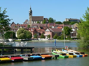
Böblingen
Town in Baden-Württemberg, Germany
Distance: Approx. 5386 meters
Latitude and longitude: 48.68555556,9.01527778
Böblingen (German pronunciation: [ˈbøːblɪŋən] ; Swabian: Beblenga) is a town in Baden-Württemberg, Germany, seat of Böblingen District. Sindelfingen and Böblingen are contiguous.

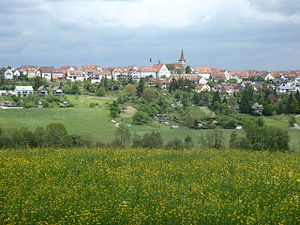
Holzgerlingen
Town in Baden-Württemberg, Germany
Distance: Approx. 564 meters
Latitude and longitude: 48.63916667,9.01083333
Holzgerlingen (German pronunciation: [hɔlt͡sˈɡɛʁlɪŋən] ) is a municipality in the German Federal State of Baden-Württemberg. It is located in district of Böblingen.

Schönaich
Municipality in Baden-Württemberg, Germany
Distance: Approx. 3966 meters
Latitude and longitude: 48.65694444,9.06277778
Schönaich (German pronunciation: [ˈʃøːnaɪç]) is a municipality in the district of Böblingen, Baden-Württemberg, Germany. It is situated 5 km southeast of Böblingen, and 16 km southwest of Stuttgart. Schönaich is a township with a population of about 10,000 and is situated at the outskirts of the Schönbuch forest in a scenic location but at the same time close to cities like Böblingen, Sindelfingen, Tübingen, and Stuttgart.
Böblingen Airport
Former airport of Stuttgart, Baden-Württemberg, Germany (1915–1992)
Distance: Approx. 5302 meters
Latitude and longitude: 48.68333333,9
Böblingen Airport (German: Flughafen Böblingen) (IATA: PHM) was built in the mid-1920s for the city of Stuttgart, the capital of the German state of Baden-Württemberg. Bordered by Calwer Straße (K1073) and the E41, it lies northwest of Böblingen and south of the Daimler factory in Sindelfingen. An aircraft industry developed around this airfield, which was used by the military during the Second World War.
Weil im Schönbuch
Municipality in Baden-Württemberg, Germany
Distance: Approx. 3634 meters
Latitude and longitude: 48.62138889,9.06111111
Weil im Schönbuch is a municipality in the Böblingen district, middle Neckar region, Stuttgart governmental district, Baden-Württemberg, Germany. Its name is derived from the presence of a Roman villa in the area. Two smaller villages, Neuweiler and Breitenstein, are incorporated into Weil im Schönbuch.
Sporthalle (Böblingen)
Distance: Approx. 4557 meters
Latitude and longitude: 48.67813889,9.01736111
Sporthalle was an indoor arena located in Böblingen, Germany. It opened in 1966 and was torn down in 2008. Sporthalle had a capacity to hold 6,500 people.

Altdorf, Böblingen
Municipality in Baden-Württemberg, Germany
Distance: Approx. 1840 meters
Latitude and longitude: 48.63055556,8.995
Altdorf is a municipality in the district of Böblingen in Baden-Württemberg in Germany.

Hildrizhausen
Municipality in Baden-Württemberg, Germany
Distance: Approx. 3777 meters
Latitude and longitude: 48.625,8.97
Hildrizhausen is a municipality in the district of Böblingen in Baden-Württemberg in Germany.

Bromberg (Schönbuch)
Distance: Approx. 5039 meters
Latitude and longitude: 48.59416667,8.99666667
The Bromberg is a hill in Baden-Württemberg, Germany.

Böblingen station
Railway station in Böblingen, Germany
Distance: Approx. 5683 meters
Latitude and longitude: 48.6875,9.00472222
Böblingen station is located on the Stuttgart–Horb railway (German: Gäubahn) and is at the start of the Rankbach Railway (Rankbachbahn) and the Schönbuch Railway (Schönbuchbahn). It is served by regional services and Stuttgart S-Bahn line S 1. Until 2002 it was served by Intercity-Express and Cisalpino services.
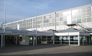
Panzer Kaserne
US military installation in Böblingen, Germany
Distance: Approx. 5378 meters
Latitude and longitude: 48.6818,9.046
Panzer Kaserne (or Camp Panzer Kaserne), is a U.S. military installation in Böblingen, Germany, part of U.S. Army Garrison Stuttgart.
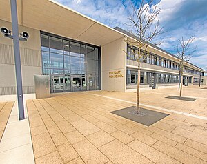
Stuttgart High School (Germany)
Dodea high school in Böblingen, Baden-Württemberg, Germany
Distance: Approx. 5797 meters
Latitude and longitude: 48.6835,9.054
Stuttgart High School (SHS) is an English-language high school in southwest Germany, in Baden-Württemberg. Southwest of Stuttgart on Panzer Kaserne in Böblingen, it is operated by the United States' DODEA (formerly known as DoDDS). Opened in 2014, its enrollment is primarily dependents of military, civilian, and contract employees of the U.S. Department of Defense (DOD) who are assigned to units of the Stuttgart Military Community, which includes Patch Barracks, Robinson Barracks, Panzer Kaserne, and Kelley Barracks.
Weather in this IP's area
clear sky
21 Celsius
21 Celsius
20 Celsius
22 Celsius
1017 hPa
49 %
1017 hPa
964 hPa
10000 meters
6.69 m/s
60 degree
07:06:38
19:28:44