Country:
 Germany
Region:
City:
Latitude and Longitude:
Time Zone:
Postal Code:
IP information under different IP Channel
ip-api
Country
Region
City
ASN
Time Zone
ISP
Blacklist
Proxy
Latitude
Longitude
Postal
Route
IPinfo
Country
Region
City
ASN
Time Zone
ISP
Blacklist
Proxy
Latitude
Longitude
Postal
Route
MaxMind
Country
Region
City
ASN
Time Zone
ISP
Blacklist
Proxy
Latitude
Longitude
Postal
Route
Luminati
Country
DERegion
bw
City
besigheim
ASN
Time Zone
Europe/Berlin
ISP
Vodafone GmbH
Latitude
Longitude
Postal
db-ip
Country
Region
City
ASN
Time Zone
ISP
Blacklist
Proxy
Latitude
Longitude
Postal
Route
ipdata
Country
Region
City
ASN
Time Zone
ISP
Blacklist
Proxy
Latitude
Longitude
Postal
Route
Popular places and events near this IP address

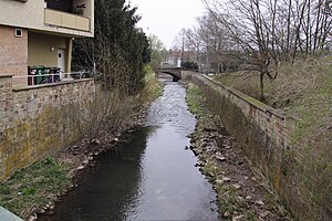
Enz
River in Germany
Distance: Approx. 1063 meters
Latitude and longitude: 49.00555556,9.14777778
The Enz is a river flowing north from the Black Forest to the Neckar in Baden-Württemberg. It is 106 km long. Its headstreams – the Little Enz (German: Kleine Enz) and the Great Enz or Big Enz (Große Enz) – rise in the Northern Black Forest, the latter at Enzklösterle.
Mundelsheim
Municipality in Baden-Württemberg, Germany
Distance: Approx. 4561 meters
Latitude and longitude: 49,9.20638889
Mundelsheim is a municipality in the German state of Baden-Wuerttemberg. It is located in the Ludwigsburg district, about 30 km north of Stuttgart and 20 km south of Heilbronn, on the Neckar river. It belongs to the Stuttgart Metropolitan Region.

Gemmrigheim
German municipality
Distance: Approx. 3369 meters
Latitude and longitude: 49.02527778,9.1575
Gemmrigheim is municipality in the district of Ludwigsburg, in Baden-Württemberg, Germany.

Hessigheim
German municipality
Distance: Approx. 3205 meters
Latitude and longitude: 48.99527778,9.18805556
Hessigheim (Swabian: Hesge) is a municipality in the Ludwigsburg district of Baden-Württemberg, Germany.
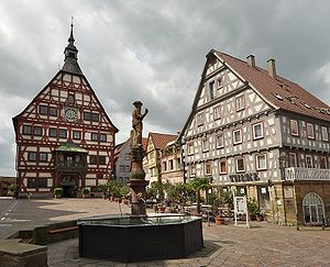
Besigheim
Municipality in Baden-Württemberg, Germany
Distance: Approx. 292 meters
Latitude and longitude: 48.99833333,9.14166667
Besigheim (German pronunciation: [ˈbeːzɪçˌhaɪ̯m] ) is a municipality in the district of Ludwigsburg in Baden-Württemberg in southern Germany. It is situated 13 km north of Ludwigsburg at the confluence of the Neckar and Enz rivers. The town has many old buildings and a town hall that dates back to 1459.

Bietigheim-Bissingen
Town in Baden-Württemberg, Germany
Distance: Approx. 3393 meters
Latitude and longitude: 48.96666667,9.13333333
Bietigheim-Bissingen (locally: Biedge-Bissenge) is the second-largest town in the district of Ludwigsburg, Baden-Württemberg, Germany with 42,515 inhabitants in 2007. It is situated on the river Enz and the river Metter, close to its confluence with the Neckar, about 19 km north of Stuttgart, and 20 km south of Heilbronn.

Löchgau
German municipality
Distance: Approx. 2687 meters
Latitude and longitude: 49.00166667,9.10833333
Löchgau is a municipality in the Ludwigsburg district of Baden-Württemberg, Germany.

Walheim
Municipality in Baden-Württemberg, Germany
Distance: Approx. 1822 meters
Latitude and longitude: 49.01166667,9.15277778
Walheim is a town in the district of Ludwigsburg, Baden-Württemberg, Germany with a considerable viticulture. Besides the village Walheim there are no other places belonging to the municipal area of Walheim.

Erligheim
German municipality
Distance: Approx. 4086 meters
Latitude and longitude: 49.01833333,9.09944444
Erligheim is a municipality in the district of Ludwigsburg in Baden-Württemberg in Germany.
Metter (river)
River in Germany
Distance: Approx. 3106 meters
Latitude and longitude: 48.97,9.13
The Metter is a river of Baden-Württemberg, Germany. It flows into the Enz in Bietigheim-Bissingen.
Kirchheim (Neckar) station
Railway station in Kirchheim am Neckar, Germany
Distance: Approx. 4610 meters
Latitude and longitude: 49.0375,9.150556
Kirchheim (Neckar) station is located at line-kilometre 35.2 on the Franconia Railway (Frankenbahn) in Kirchheim am Neckar in the German state of Baden-Württemberg. According to the Railway Construction and Operating Regulations, it is considered to be a Haltepunkt (roughly: "halt"), not a station.
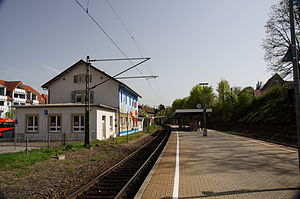
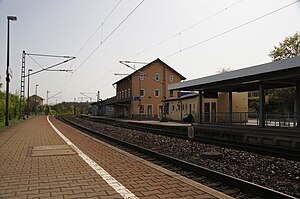
Besigheim station
Railway station in Besigheim, Germany
Distance: Approx. 586 meters
Latitude and longitude: 48.9975,9.136389
Besigheim station is located at line-kilometre 29.8 on the Franconia Railway (Frankenbahn) in Besigheim in the German state of Baden-Württemberg. According to the Railway Construction and Operating Regulations, it is considered to be a Haltepunkt (roughly: "halt"), not a station.
Weather in this IP's area
clear sky
24 Celsius
23 Celsius
22 Celsius
24 Celsius
1017 hPa
39 %
1017 hPa
995 hPa
10000 meters
5.17 m/s
7.48 m/s
74 degree
07:06:01
19:28:21