Country:
 Germany
Region:
City:
Latitude and Longitude:
Time Zone:
Postal Code:
IP information under different IP Channel
ip-api
Country
Region
City
ASN
Time Zone
ISP
Blacklist
Proxy
Latitude
Longitude
Postal
Route
IPinfo
Country
Region
City
ASN
Time Zone
ISP
Blacklist
Proxy
Latitude
Longitude
Postal
Route
MaxMind
Country
Region
City
ASN
Time Zone
ISP
Blacklist
Proxy
Latitude
Longitude
Postal
Route
Luminati
Country
DERegion
bw
City
waldkirch
ASN
Time Zone
Europe/Berlin
ISP
Vodafone GmbH
Latitude
Longitude
Postal
db-ip
Country
Region
City
ASN
Time Zone
ISP
Blacklist
Proxy
Latitude
Longitude
Postal
Route
ipdata
Country
Region
City
ASN
Time Zone
ISP
Blacklist
Proxy
Latitude
Longitude
Postal
Route
Popular places and events near this IP address

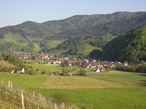
Waldkirch
Town in Baden-Württemberg, Germany
Distance: Approx. 842 meters
Latitude and longitude: 48.1,7.96666667
Waldkirch (German pronunciation: [ˈvaltˌkɪʁç] ) is a town in Baden-Württemberg, Germany, located 15 kilometers northeast of Freiburg im Breisgau. While the English translation of its name is Forest Church, it is known as the "town of mechanical organs", where fairground organs played on the streets were long manufactured by such well-known firms as Carl Frei (later of Breda, Netherlands), Andreas Ruth and Son, and Wilhelm Bruder and Sons. The largest employers today are SICK AG, which manufactures optical sensors, Faller AG, which prints pharmaceutical packages and inserts, and Mack Rides, which exports amusement park and water park rides worldwide.

Hochburg
Castle ruin in SW Germany
Distance: Approx. 4990 meters
Latitude and longitude: 48.11666667,7.90055556
The Hochburg ("high castle") is a castle ruin situated between the city of Emmendingen and the village of Sexau in the region of Baden, located in the southwest of Germany. It was presumably built in the 11th century and was originally known as castle Hachberg. The line of nobles known as the Margraves of Baden-Hachberg most likely derive their name from this castle and before it was razed by the French it was the second largest fortification in Baden.
Glottertal
Municipality in Baden-Württemberg, Germany
Distance: Approx. 5117 meters
Latitude and longitude: 48.04861111,7.955
Glottertal is a municipality in the district of Breisgau-Hochschwarzwald in Baden-Württemberg in southern Germany.

Heuweiler
Municipality in Baden-Württemberg, Germany
Distance: Approx. 6324 meters
Latitude and longitude: 48.05166667,7.90305556
Heuweiler is a village in the district of Breisgau-Hochschwarzwald in the southwest of Baden-Württemberg near Freiburg in southern Germany. The village has to a large extent retained its rural character. Whereas many communities in the vicinity of Freiburg have grown rapidly in recent decades a slow, organic change occurred in Heuweiler.

Gutach im Breisgau
Municipality in Baden-Württemberg, Germany
Distance: Approx. 3459 meters
Latitude and longitude: 48.11777778,7.98972222
Gutach (Low Alemannic: Guetich im Brisgau) is a municipality in the district of Emmendingen in Baden-Württemberg in Germany.

Sexau
Municipality in Baden-Württemberg, Germany
Distance: Approx. 3818 meters
Latitude and longitude: 48.10305556,7.90916667
Sexau (Low Alemannic: Säxoi) is a village in the district of Emmendingen in Baden-Württemberg in Germany.

Kandel (mountain)
Distance: Approx. 5336 meters
Latitude and longitude: 48.06222222,8.01194444
The Kandel is a mountain, 1,241.4 metres high, in the Black Forest in the south of Baden-Württemberg, Germany.

Wild Gutach
River in Germany
Distance: Approx. 3695 meters
Latitude and longitude: 48.1205,7.9898
The Wild Gutach (German: Wilde Gutach) is a river in Baden-Württemberg, Germany. It flows into the Elz in Gutach im Breisgau.

Kastelburg
Distance: Approx. 344 meters
Latitude and longitude: 48.0975,7.95777778
The Kastelburg is a ruined castle above Waldkirch in the district Emmendingen in Baden-Württemberg. It stands on a hill about 100 meters (330 feet) above the center of Waldkirch in Breisgau.

Schwarzenburg (Breisgau)
Distance: Approx. 2727 meters
Latitude and longitude: 48.07017222,7.96318056
The Schwarzenburg (Black Castle), historically called Schwarzenberg (Black Mountain), is a castle near Waldkirch in the district Emmendingen in the southwest of Baden-Württemberg in southern Germany.
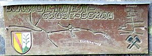
Caroline Pit
Mine in Sexau, county of Emmendingen, Baden-Württemberg, Germany
Distance: Approx. 4551 meters
Latitude and longitude: 48.12557222,7.91910833
The Caroline Pit (German: Grube Caroline) in the Eberbächle, a side valley of the Brettenbach, is an old silver mine in Sexau in the Black Forest in Germany which is open to the public as a show mine. In 1987, volunteers began to uncover the pit and maintain it. It lies within the mining region of Sexau and Freiamt.

Hornberg (Breisgau)
Distance: Approx. 4778 meters
Latitude and longitude: 48.10833333,7.89805556
The Hornberg is a hill in the northern Breisgau in Baden-Württemberg, Germany. It is an outlier of the Black Forest, running as a north-south ridge between the villages of Windenreute, Kollmarsreute and Sexau into the Upper Rhine Plain. At its northern end is the Hochburg, one of the largest fortresses in South Baden.
Weather in this IP's area
scattered clouds
23 Celsius
23 Celsius
22 Celsius
24 Celsius
1016 hPa
48 %
1016 hPa
983 hPa
10000 meters
4.27 m/s
7.16 m/s
68 degree
33 %
07:11:02
19:32:48