Country:
 Germany
Region:
City:
Latitude and Longitude:
Time Zone:
Postal Code:
IP information under different IP Channel
ip-api
Country
Region
City
ASN
Time Zone
ISP
Blacklist
Proxy
Latitude
Longitude
Postal
Route
IPinfo
Country
Region
City
ASN
Time Zone
ISP
Blacklist
Proxy
Latitude
Longitude
Postal
Route
MaxMind
Country
Region
City
ASN
Time Zone
ISP
Blacklist
Proxy
Latitude
Longitude
Postal
Route
Luminati
Country
DERegion
bw
City
heilbronn
ASN
Time Zone
Europe/Berlin
ISP
Vodafone GmbH
Latitude
Longitude
Postal
db-ip
Country
Region
City
ASN
Time Zone
ISP
Blacklist
Proxy
Latitude
Longitude
Postal
Route
ipdata
Country
Region
City
ASN
Time Zone
ISP
Blacklist
Proxy
Latitude
Longitude
Postal
Route
Popular places and events near this IP address
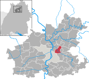
Heilbronn (district)
District in Baden-Württemberg, Germany
Distance: Approx. 1481 meters
Latitude and longitude: 49.16,9.25
Landkreis Heilbronn (German pronunciation: [haɪlˈbʁɔn] ) is a Landkreis (district) in the north of Baden-Württemberg, Germany. Neighboring districts are (from north clockwise) Neckar-Odenwald, Hohenlohe, Schwäbisch Hall, Rems-Murr, Ludwigsburg, Enz, Karlsruhe and Rhein-Neckar. In the centre of it is the free-city of Heilbronn, which is its own separate administrative area.

Weinsberg
Town in Baden-Württemberg, Germany
Distance: Approx. 2467 meters
Latitude and longitude: 49.15180556,9.28569444
Weinsberg (South Franconian: Weischberg) is a town in the north of the state of Baden-Württemberg in Germany. It was founded around 1200 and is situated in the Heilbronn district. The town has about 13,000 inhabitants.
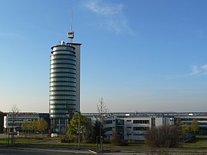
Neckarsulm TDS Office Tower
Distance: Approx. 2673 meters
Latitude and longitude: 49.18138889,9.23305556
Neckarsulm TDS Office Tower is a 70 metres (230 ft)tall, 20 floor tall office building in Neckarsulm, Germany. Neckarsulm TDS Office Tower houses the offices of TDS AG, dsb AG and the LIDL training center. TDS Office Tower was constructed during the period 1997 to 1999.
Erlenbach, Baden-Württemberg
Municipality in Baden-Württemberg, Germany
Distance: Approx. 316 meters
Latitude and longitude: 49.16666667,9.26666667
Erlenbach (German: [ˈɛʁlənbax] ) is a municipality in the district of Heilbronn in Baden-Württemberg in southern Germany.

Siege of Weinsberg
1140 battle between the Welfs and Hohenstaufens dynasties
Distance: Approx. 2067 meters
Latitude and longitude: 49.155,9.283
The siege of Weinsberg took place in 1140 in Weinsberg, in the modern state of Baden-Württemberg, Germany, which was then part of the Holy Roman Empire. The siege was a decisive battle between two dynasties, the Welfs and the Hohenstaufen. The Welfs for the first time changed their war cry from "Kyrie Eleison" to their party cries.

Galgenberg (Heilbronn)
Distance: Approx. 2422 meters
Latitude and longitude: 49.1475,9.26222222
Galgenberg (Heilbronn) is a mountain of Baden-Württemberg, Germany.

Scheuerberg
Distance: Approx. 3238 meters
Latitude and longitude: 49.19722222,9.25277778
Scheuerberg is a mountain of Baden-Württemberg, Germany.

Wartberg (Heilbronn)
Distance: Approx. 2406 meters
Latitude and longitude: 49.15972222,9.235
The Wartberg is a hill in Baden-Württemberg, Germany.
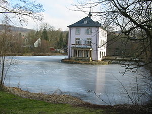
Trappensee
Lake in Baden-Wuerttemberg, Germany
Distance: Approx. 3469 meters
Latitude and longitude: 49.13888889,9.25361111
Trappensee is a small lake in the eastern city of Heilbronn in northern Baden-Wuerttemberg, Baden-Wuerttemberg, Germany. It is approximately 2 kilometres (1.2 mi) east of the city center. In the middle of the lake there is the Trappensee castle, a water castle that dates back to the 16th century and was rebuilt in its current shape in the 18th century.
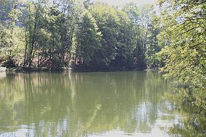
Stadtseebach
River in Germany
Distance: Approx. 234 meters
Latitude and longitude: 49.1683,9.2676
Stadtseebach is a river of Baden-Württemberg, Germany. Another name, however not any longer officially used, is Saubach. It flows into the Sulm in Erlenbach.

Staatliche Lehr- und Versuchsanstalt für Wein- und Obstbau Weinsberg
School in Weinsberg, Baden-Württemberg, Germany
Distance: Approx. 2688 meters
Latitude and longitude: 49.15111111,9.28916667
Staatliche Lehr- und Versuchsanstalt für Wein- und Obstbau Weinsberg (English: State Education and Research Institute for Viticulture and Pomology Weinsberg) (LVWO) is a training and research institute for wine and fruit growing located in the town of Weinsberg in Heilbronn district, Baden-Württemberg, Germany. Founded as Königliche Weinbauschule (Royal School of Viticulture Institute) in 1868, it is the oldest German wine and fruit growing school. The founder was Immanuel Dornfeld.
Klinikum am Weissenhof
German psychiatric hospital, opened 1903
Distance: Approx. 2134 meters
Latitude and longitude: 49.1653,9.2934
The Klinikum am Weissenhof is a psychiatric hospital in Weinsberg. It was opened in 1903 as a royal sanatorium on the public domain of Weißenhof.
Weather in this IP's area
clear sky
24 Celsius
23 Celsius
22 Celsius
25 Celsius
1018 hPa
38 %
1018 hPa
998 hPa
10000 meters
0.45 m/s
0.45 m/s
225 degree
07:05:29
19:27:55