Country:
Region:
City:
Latitude and Longitude:
Time Zone:
Postal Code:
IP information under different IP Channel
ip-api
Country
Region
City
ASN
Time Zone
ISP
Blacklist
Proxy
Latitude
Longitude
Postal
Route
Luminati
Country
Region
bw
City
neckarsulm
ASN
Time Zone
Europe/Berlin
ISP
Vodafone GmbH
Latitude
Longitude
Postal
IPinfo
Country
Region
City
ASN
Time Zone
ISP
Blacklist
Proxy
Latitude
Longitude
Postal
Route
db-ip
Country
Region
City
ASN
Time Zone
ISP
Blacklist
Proxy
Latitude
Longitude
Postal
Route
ipdata
Country
Region
City
ASN
Time Zone
ISP
Blacklist
Proxy
Latitude
Longitude
Postal
Route
Popular places and events near this IP address

Kolbenschmidt Arena
Distance: Approx. 2857 meters
Latitude and longitude: 49.14611111,9.21527778
Kolbenschmidt Arena is an arena in Heilbronn, Germany. It is primarily used for hockey. Kolbenschmidt Arena opened in 2002 and has a viewer capacity of 4,000.

Flein
Municipality in Baden-Württemberg, Germany
Distance: Approx. 3051 meters
Latitude and longitude: 49.1,9.21666667
Flein (German: [flaɪn] ) is a municipality in the district of Heilbronn in Baden-Württemberg in southern Germany.

Schozach
River in Germany
Distance: Approx. 693 meters
Latitude and longitude: 49.12027778,9.18805556
Schozach is a river in Germany. It is a right tributary of the Neckar in the southern part of the Heilbronn district of Baden-Württemberg. It has its source near the village Vorhof near Untergruppenbach in the Löwenstein Hills and flows through Oberheinriet, Unterheinriet, Abstatt, Auenstein, Ilsfeld, Schozach and Talheim, and Heilbronn, before it flows into the Neckar near Sontheim, part of Heilbronn.

South German Railway Museum
Museum in Heilbronn, Baden-Württemberg, Germany
Distance: Approx. 1794 meters
Latitude and longitude: 49.13978,9.19268
The South German Railway Museum (Süddeutsches Eisenbahnmuseum Heilbronn or SEH) is a railway museum at Heilbronn in the state of Baden-Württemberg in southwestern Germany. It was founded in 1998.

St. Kilian's Church, Heilbronn
Distance: Approx. 2613 meters
Latitude and longitude: 49.14166667,9.21916667
Kilian's Church on Kaiserstraße (Kaiser Street) in Heilbronn is a Gothic hall church constructed from Heilbronner sandstone, whose origin dates back to the 11th century. Its western tower, constructed by Hans Schweiner, is one of the first major Renaissance buildings to be built north of the Alps. Inside the church there is an altar by Hans Seyffer from 1498, which is regarded as a masterpiece of sculpture from the Late German Gothic period.

Heilbronn University of Applied Sciences
German university
Distance: Approx. 1127 meters
Latitude and longitude: 49.12194444,9.21111111
Heilbronn University of Applied Sciences, (German: Hochschule Heilbronn), is a German University of Applied Sciences with campuses in Heilbronn-Sontheim, in the centre of Heilbronn (Bildungscampus), in Künzelsau and Schwäbisch Hall. Heilbronn University of Applied Sciences ranks amongst the major institutions of Higher Education in the state of Baden-Württemberg where it caters for over 8,000 degree-seeking students on three campuses, namely Heilbronn, Künzelsau and Schwäbisch Hall. The university's second campus is located in Künzelsau, the economic centre of the Hohenlohe district, its third in Schwäbisch Hall.

Heilbronn Hauptbahnhof
Railway station in Germany
Distance: Approx. 2291 meters
Latitude and longitude: 49.14277778,9.20805556
Heilbronn Hauptbahnhof (German: [haɪlˈbʁɔn ˈhaʊptbaːnˌhoːf] ) is the main passenger railway station in Heilbronn in the German state of Baden-Württemberg.

Pfühlbach
River in Germany
Distance: Approx. 2808 meters
Latitude and longitude: 49.146,9.2142
Pfühlbach is a small river of Baden-Württemberg, Germany. It flows into the Neckar in Heilbronn.
Theater Heilbronn
Distance: Approx. 3126 meters
Latitude and longitude: 49.14583333,9.2225
Theater Heilbronn is a theatre in Heilbronn, Baden-Württemberg, Germany.

Theodor-Heuss-Gymnasium Heilbronn
School in Heilbronn, Germany
Distance: Approx. 3077 meters
Latitude and longitude: 49.142639,9.226806
The Theodor-Heuss-Gymnasium Heilbronn is a Gymnasium in the city of Heilbronn. The roots of school date from a Lateinschule (Latin school) of the 15th century. In 1620, the school was converted into a Gymnasium.

Buga Wood Pavilion
Experimental structure in Heilbronn, Germany
Distance: Approx. 2825 meters
Latitude and longitude: 49.14811111,9.20702778
The BUGA Wood Pavilion (also known as BUGA Holzpavillion) is a 500 m2 (5,400 sq ft) experimental shell structure that served as an open event space with a multi-purpose stage at the Bundesgartenschau 2019 in Heilbronn.

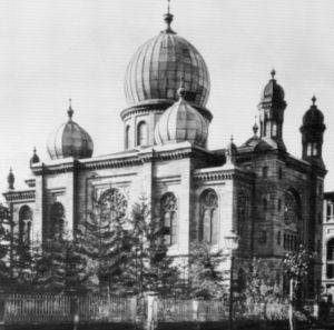
Old Synagogue (Heilbronn)
Former synagogue in Heilbronn, Germany
Distance: Approx. 2517 meters
Latitude and longitude: 49.14,9.22
The Heilbronn Synagogue was a Jewish congregation and synagogue, located in Heilbronn, in the state of Baden-Württemberg, Germany. The synagogue, located on Allee and constructed from local sandstone, was designed by Stuttgart architect Adolf Wolff in the Moorish Revival style and is regarded as the high point in the Neo-Orientalism phase in synagogue construction.: 1:152 The synagogue was completed in 1877 and demolished in 1940 following desecration by Nazis during Kristallnacht in November 1938. A memorial stone and a sculpture are located on the site of the former synagogue.
Weather in this IP's area
overcast clouds
7 Celsius
6 Celsius
7 Celsius
8 Celsius
1028 hPa
82 %
1028 hPa
1008 hPa
10000 meters
2.08 m/s
3.01 m/s
74 degree
100 %
07:22:26
16:51:35