Country:
Region:
City:
Latitude and Longitude:
Time Zone:
Postal Code:
IP information under different IP Channel
ip-api
Country
Region
City
ASN
Time Zone
ISP
Blacklist
Proxy
Latitude
Longitude
Postal
Route
Luminati
Country
Region
nw
City
kleve
ASN
Time Zone
Europe/Berlin
ISP
Vodafone GmbH
Latitude
Longitude
Postal
IPinfo
Country
Region
City
ASN
Time Zone
ISP
Blacklist
Proxy
Latitude
Longitude
Postal
Route
db-ip
Country
Region
City
ASN
Time Zone
ISP
Blacklist
Proxy
Latitude
Longitude
Postal
Route
ipdata
Country
Region
City
ASN
Time Zone
ISP
Blacklist
Proxy
Latitude
Longitude
Postal
Route
Popular places and events near this IP address

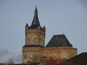
Kleve
Place in North Rhine-Westphalia, Germany
Distance: Approx. 590 meters
Latitude and longitude: 51.79,6.14
Kleve (German: [ˈkleːvə] ; traditional English: Cleves KLEEVZ; Dutch: Kleef; French: Clèves; Spanish: Cléveris; Latin: Clivia; Low Rhenish: Kleff) is a town in the Lower Rhine region of northwestern Germany near the Dutch border and the River Rhine. From the 11th century onwards, Cleves was capital of a county and later a duchy. Today, Cleves is the capital of the district of Kleve in the German state of North Rhine-Westphalia.

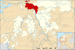
Duchy of Cleves
State of the Holy Roman Empire
Distance: Approx. 484 meters
Latitude and longitude: 51.78333333,6.13333333
The Duchy of Cleves (German: Herzogtum Kleve; Dutch: Hertogdom Kleef) was a state of the Holy Roman Empire which emerged from the medieval Hettergau. It was situated in the northern Rhineland on both sides of the Lower Rhine, around its capital Cleves and the towns of Wesel, Kalkar, Xanten, Emmerich, Rees and Duisburg bordering the lands of the Prince-Bishopric of Münster in the east and the Duchy of Brabant in the west. Its history is closely related to that of its southern neighbours: the Duchies of Jülich and Berg, as well as Guelders and the Westphalian county of Mark.
Kleve transmitter
Distance: Approx. 1998 meters
Latitude and longitude: 51.78638889,6.11111111
Kleve transmitter is a facility for FM and TV transmission (until 1993 also medium wave transmission) of the WDR near Kleve in North Rhine-Westphalia, Germany. The Kleve transmitter was founded in 1953. Since 1994, the transmitter uses as a transmission tower a 126.4 metres (415 feet) high guyed steel tube mast.

Bedburg-Hau
Municipality in North Rhine-Westphalia, Germany
Distance: Approx. 3597 meters
Latitude and longitude: 51.76666667,6.18333333
Bedburg-Hau is a municipality in the district of Kleve in the state of North Rhine-Westphalia, Germany. It is located approximately 5 km south-east of Kleve. One of its main attractions is Museum Schloss Moyland, a castle with a museum of modern art dedicated to the German artist Joseph Beuys.
XOX-Theater Kleve
Distance: Approx. 1157 meters
Latitude and longitude: 51.79416667,6.14694444
XOX-Theater Kleve is a theatre in Kleve, North Rhine-Westphalia, Germany.

Rhine-Waal University of Applied Sciences
Distance: Approx. 1079 meters
Latitude and longitude: 51.7937,6.1458
Rhine-Waal University of Applied Sciences (German: Hochschule Rhein-Waal) or HSRW, is a 2009-founded German university of applied sciences based in the cities of Kleve and Kamp-Lintfort, Germany. It is internationally-oriented and delivers a variety of English- and German-language study programmes across four faculties: Technology and Bionics, Life Sciences, Society and Economics, and Communication and Environment. The university is named after the rivers Rhine and Waal.
Nütterden
Distance: Approx. 5246 meters
Latitude and longitude: 51.7894,6.0642
Nütterden is a village in the municipality of Kranenburg, Kreis Kleve in the German State of North Rhine-Westphalia.

Donsbrüggen
Village in Germany
Distance: Approx. 3578 meters
Latitude and longitude: 51.8014,6.0956
Donsbrüggen is a village in the municipality of Kleve, Kreis Kleve in the German State of North Rhine-Westphalia, with some 1,500 current residents.
Griethausen
Village and former city in Germany
Distance: Approx. 4492 meters
Latitude and longitude: 51.8219,6.1653
Griethausen is a village and former city in the municipality of Kleve, Kreis Kleve in the German State of North Rhine-Westphalia. The village is located at the Griethauser Altrhein. One of the points of interest in the village is the old steelbridge across.

Kleve station
Railway station in Kleve, Germany
Distance: Approx. 703 meters
Latitude and longitude: 51.78916667,6.14722222
Kleve is a railway station in the town of Kleve, North Rhine Westphalia, Germany. The station opened on 5 March 1863 on the Lower Left Rhine Railway. The train services are operated by NordWestBahn.
Johanna-Sebus-Gymnasium
Closed school in Kleve, Germany
Distance: Approx. 1265 meters
Latitude and longitude: 51.78038889,6.123
The Johanna-Sebus-Gymnasium was a school in the city of Kleve which closed in 2010 due to low enrollment. It merged with Freiherr-vom-Stein-Gymnasium. The school was founded in 1935.

Rindern
Stadtteil of Kleve in North Rhine-Westphalia, Germany
Distance: Approx. 3177 meters
Latitude and longitude: 51.81111111,6.1225
Rindern is a village in the Kleve (district) of Lower Rhine region of Germany. It is part of the town Kleve.
Weather in this IP's area
clear sky
5 Celsius
2 Celsius
4 Celsius
6 Celsius
1029 hPa
87 %
1029 hPa
1027 hPa
10000 meters
3.06 m/s
4.51 m/s
72 degree
07:42:44
16:55:45
