149.154.75.92 - IP Lookup: Free IP Address Lookup, Postal Code Lookup, IP Location Lookup, IP ASN, Public IP
Country:
 Germany
Region:
City:
Location:
Time Zone:
Postal Code:
ISP:
ASN:
language:
User-Agent:
Proxy IP:
Blacklist:
IP information under different IP Channel
ip-api
Country
Region
City
ASN
Time Zone
ISP
Blacklist
Proxy
Latitude
Longitude
Postal
Route
db-ip
Country
Region
City
ASN
Time Zone
ISP
Blacklist
Proxy
Latitude
Longitude
Postal
Route
IPinfo
Country
Region
City
ASN
Time Zone
ISP
Blacklist
Proxy
Latitude
Longitude
Postal
Route
IP2Location
149.154.75.92Country
deRegion
sachsen-anhalt
City
schwanebeck
Time Zone
ISP
Language
User-Agent
Latitude
Longitude
Postal
ipdata
Country
Region
City
ASN
Time Zone
ISP
Blacklist
Proxy
Latitude
Longitude
Postal
Route
Popular places and events near this IP address
Gröningen
Town in Saxony-Anhalt, Germany
Distance: Approx. 7438 meters
Latitude and longitude: 51.93333333,11.21666667
Gröningen (German pronunciation: [ˈɡʁøːnɪŋən] ) is a town in the Börde district in Saxony-Anhalt, Germany. It lies approx. 40 km south-west of Magdeburg, and 10 km east of Halberstadt.

Gröningen Priory
German Benedictine monastery, 936–1542
Distance: Approx. 6064 meters
Latitude and longitude: 51.93722222,11.19694444
Gröningen Priory (German: Kloster Gröningen) was a Benedictine monastery, located west of Gröningen in present-day Saxony-Anhalt, Germany. The abbey church is part of the Romanesque Road scenic route.

Huysburg
Benedictine monastery in Germany
Distance: Approx. 8408 meters
Latitude and longitude: 51.96027778,11.00194444
Huysburg ([ˈhyːsbʊrk]; German: Kloster Huysburg) is a Benedictine monastery situated on the Huy hill range near Halberstadt, in the German state of Saxony-Anhalt. The Romanesque abbey has existed since about 1080 and was secularised in 1804. A new Benedictine community was founded in 1972 and has been headed by a prior since 1984.

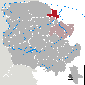
Westliche Börde
Municipality in Saxony-Anhalt, Germany
Distance: Approx. 7438 meters
Latitude and longitude: 51.93333333,11.21666667
Westliche Börde is a Verbandsgemeinde ("collective municipality") in the Börde district in Saxony-Anhalt, Germany. Before 1 January 2010, it was a Verwaltungsgemeinschaft. It is situated approximately 35 km southwest of Magdeburg, in the western part of the Magdeburger Börde.
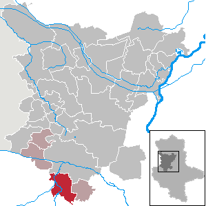
Schwanebeck
Town in Saxony-Anhalt, Germany
Distance: Approx. 215 meters
Latitude and longitude: 51.9675,11.12083333
Schwanebeck is a small town in the district of Harz, in Saxony-Anhalt, Germany. It is part of the Verbandsgemeinde ("collective municipality") Vorharz. The municipal area is situated northeast of Halberstadt, on the Bundesstraße 245 highway to Hamersleben.
Wulferstedt
Ortsteil of Am Großen Bruch in Saxony-Anhalt, Germany
Distance: Approx. 5467 meters
Latitude and longitude: 52.01666667,11.13333333
Wulferstedt is a village and a former municipality in the Börde district in Saxony-Anhalt, Germany. Since 1 January 2010, it is part of the municipality Am Großen Bruch.
Nienhagen, Saxony-Anhalt
Stadtteil of Schwanebeck in Saxony-Anhalt, Germany
Distance: Approx. 3546 meters
Latitude and longitude: 51.95,11.16666667
Nienhagen is a village and a former municipality in the district of Harz, in Saxony-Anhalt, Germany. Since 1 January 2010, it is part of the town Schwanebeck.

Groß Quenstedt
Municipality in Saxony-Anhalt, Germany
Distance: Approx. 4567 meters
Latitude and longitude: 51.92805556,11.10805556
Groß Quenstedt is a municipality in the district of Harz, in Saxony-Anhalt, Germany.
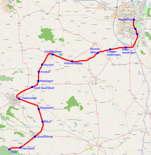
Hordorf train collision
Distance: Approx. 5899 meters
Latitude and longitude: 52.00055556,11.19166667
On 29 January 2011, a freight train and a passenger train collided near Hordorf in Saxony-Anhalt, Germany on the Magdeburg–Thale line. The passenger train derailed in the collision. Ten people were killed and 43 people were injured, some of them critically.

Daneil's Cave
CAVE LOCATED IN GERMANY
Distance: Approx. 9317 meters
Latitude and longitude: 51.96261111,10.98833333
Daneil's Cave (German: Daneilshöhle), also called Robber's Cave (Räuberhöhle) is located on the northern side of the Huy ridge in the district of Harz in the German state of Saxony-Anhalt. It is named after the legend of a notorious robber, Daneil. It forms three caverns that are linked to one another inside a rock face of Middle Bunter Sandstone, each with their own entrance.

Trams in Halberstadt
Tram system in Halberstadt, Germany
Distance: Approx. 8891 meters
Latitude and longitude: 51.90416667,11.04583333
The Halberstadt tramway (German: Straßenbahn Halberstadt) is a network of tramways forming part of the public transport system in Halberstadt, a city in Saxony-Anhalt, Germany. Opened in 1887, the network has been operated since 1992 by Halberstädter Verkehrs-GmbH (HVG), which also operates the city's bus network.

Halberstadt Hauptbahnhof
Railway station in Halberstadt, Germany
Distance: Approx. 8366 meters
Latitude and longitude: 51.89944444,11.07361111
Halberstadt Hauptbahnhof is the main station on the Magdeburg–Thale railway in Halberstadt in the German state of Saxony-Anhalt. A terminal station was opened in the town in 1843. A new through station was opened in another part of the town in 1868.
Weather in this IP's area
overcast clouds
2 Celsius
-1 Celsius
2 Celsius
2 Celsius
1041 hPa
89 %
1041 hPa
1023 hPa
10000 meters
2.56 m/s
5.11 m/s
264 degree
100 %