Country:
 Netherlands
Region:
City:
Latitude and Longitude:
Time Zone:
Postal Code:
IP information under different IP Channel
ip-api
Country
Region
City
ASN
Time Zone
ISP
Blacklist
Proxy
Latitude
Longitude
Postal
Route
IPinfo
Country
Region
City
ASN
Time Zone
ISP
Blacklist
Proxy
Latitude
Longitude
Postal
Route
MaxMind
Country
Region
City
ASN
Time Zone
ISP
Blacklist
Proxy
Latitude
Longitude
Postal
Route
Luminati
Country
NLRegion
ov
City
almelo
ASN
Time Zone
Europe/Amsterdam
ISP
DELTA Fiber Nederland B.V.
Latitude
Longitude
Postal
db-ip
Country
Region
City
ASN
Time Zone
ISP
Blacklist
Proxy
Latitude
Longitude
Postal
Route
ipdata
Country
Region
City
ASN
Time Zone
ISP
Blacklist
Proxy
Latitude
Longitude
Postal
Route
Popular places and events near this IP address

Almelo
City and municipality in Overijssel, Netherlands
Distance: Approx. 2394 meters
Latitude and longitude: 52.35,6.66666667
Almelo (Dutch pronunciation: [ˈɑlməloː] ) is a municipality and a city in the eastern Netherlands. The main population centres in the town are Aadorp, Almelo, Mariaparochie, and Bornerbroek. Almelo has about 72,000 inhabitants in the middle of the rolling countryside of Twente, with the industrial centres of Enschede and Hengelo as close neighbours but also with tourist towns like Ootmarsum, Delden and Markelo only a bicycle ride away.

Wierden
Municipality in Overijssel, Netherlands
Distance: Approx. 3500 meters
Latitude and longitude: 52.35,6.6
Wierden (Dutch pronunciation: [ˈʋiːrdə(n)] ; Tweants: Wierdn) is a town and a municipality in the eastern Netherlands, in the province of Overijssel. The municipality of Wierden also includes the following towns, villages and townships: Enter, Hoge Hexel, IJpelo, Notter, Rectum, and Zuna. The municipality has 10 primary schools and 1 secondary school.

Aadorp
Village in Overijssel, Netherlands
Distance: Approx. 5137 meters
Latitude and longitude: 52.37861111,6.62722222
Aadorp is a village on the northern side of Almelo, Netherlands with a population of about 1500; it has been part of the Almelo municipality since 2001. The villagers of Aadorp are very close, since there are so few of them. The central meeting point in Aadorp is the Aahoes, which consists of a meeting hall, and a small barbershop.

Erve Asito
Distance: Approx. 743 meters
Latitude and longitude: 52.33888889,6.65055556
Asito stadion (Dutch pronunciation: [ˈɛrvə aːˈsitoː]), formerly the Polman Stadion, is a multi-use stadium in Almelo, Netherlands. It is currently used mostly for football matches. The stadium has a capacity of 12.080 spectators and was built in 1999.
Ambt Almelo
Distance: Approx. 3244 meters
Latitude and longitude: 52.35,6.68333333
Ambt Almelo is a former municipality in the Dutch province of Overijssel. It covered the area around the city centre of Almelo. In 1913, the municipality was merged with the municipality of Almelo.
Stad Almelo
Distance: Approx. 2779 meters
Latitude and longitude: 52.354524,6.66618
Stad Almelo is a former municipality in the Dutch province of Overijssel. It consisted of the city of Almelo. It existed from 1818 to 1914, when it merged with the municipality of Ambt Almelo, which covered the surrounding countryside.

Bornerbroek
Village in Overijssel, Netherlands
Distance: Approx. 2858 meters
Latitude and longitude: 52.30888889,6.65527778
Bornerbroek (Dutch pronunciation: [bɔrnərˈbruk]) is a church village in the municipality of Almelo in Twente, the Dutch province of Overijssel. Up to the municipal reorganisation of 1 January 2001, the village was part of the municipality of Borne.

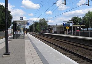
Almelo railway station
Railway station in Almelo, Netherlands
Distance: Approx. 2736 meters
Latitude and longitude: 52.35722222,6.655
Almelo is a railway station in Almelo, Netherlands. The station was opened on 18 October 1865 and is on the Deventer–Almelo railway, Almelo–Salzbergen railway, Zwolle–Almelo railway and Mariënberg–Almelo railway lines. The current station building dates from 1962.

Almelo de Riet railway station
Railway station in the Netherlands
Distance: Approx. 1806 meters
Latitude and longitude: 52.34194444,6.66666667
Almelo de Riet is a railway station located in Almelo, Netherlands. The station was opened on 3 October 1926 and is located on the Almelo-Salzbergen railway line. Previously, the station was simply called De Riet.
Wierden railway station
Railway station in the Netherlands
Distance: Approx. 4739 meters
Latitude and longitude: 52.36138889,6.59111111
Wierden is a railway station serving the village Wierden in the Netherlands. The station was opened on 1 January 1881. It is located on the Deventer–Almelo railway and the Zwolle–Almelo railway.

De Hoop, Almelo
Dutch windmill
Distance: Approx. 2057 meters
Latitude and longitude: 52.350586,6.655806
De Hoop is a gristmill in Almelo, Netherlands. The mill was built in 1870 with use of a demolished mill from 1797 and was rebuilt after a fire in 1910.

Rectum, Netherlands
Hamlet in Overijssel, Netherlands
Distance: Approx. 5016 meters
Latitude and longitude: 52.3277,6.5708
Rectum is a hamlet in the Dutch province of Overijssel. It is part of the municipality of Wierden. The hamlet is located about 4 kilometres (2.5 mi) north of Enter.
Weather in this IP's area
broken clouds
22 Celsius
22 Celsius
21 Celsius
24 Celsius
1009 hPa
61 %
1009 hPa
1008 hPa
10000 meters
6.26 m/s
8.03 m/s
203 degree
76 %
06:56:49
20:05:34