Country:
 Netherlands
Region:
City:
Latitude and Longitude:
Time Zone:
Postal Code:
IP information under different IP Channel
ip-api
Country
Region
City
ASN
Time Zone
ISP
Blacklist
Proxy
Latitude
Longitude
Postal
Route
IPinfo
Country
Region
City
ASN
Time Zone
ISP
Blacklist
Proxy
Latitude
Longitude
Postal
Route
MaxMind
Country
Region
City
ASN
Time Zone
ISP
Blacklist
Proxy
Latitude
Longitude
Postal
Route
Luminati
Country
NLRegion
zh
City
naaldwijk
ASN
Time Zone
Europe/Amsterdam
ISP
DELTA Fiber Nederland B.V.
Latitude
Longitude
Postal
db-ip
Country
Region
City
ASN
Time Zone
ISP
Blacklist
Proxy
Latitude
Longitude
Postal
Route
ipdata
Country
Region
City
ASN
Time Zone
ISP
Blacklist
Proxy
Latitude
Longitude
Postal
Route
Popular places and events near this IP address

's-Gravenzande
Town in South Holland, Netherlands
Distance: Approx. 2791 meters
Latitude and longitude: 52,4.16666667
's-Gravenzande is a town in the province of South Holland, in the Netherlands. It is a part of the municipality of Westland, and lies about 12 kilometres (7.5 mi) southwest of The Hague. Until 2004 it was a separate municipality and covered an area of 20.77 km2 (of which 3.38 km2 water).
Naaldwijk
Town in South Holland, Netherlands
Distance: Approx. 4049 meters
Latitude and longitude: 51.99305556,4.205
Naaldwijk (Dutch pronunciation: [ˈnaːltʋɛik]) is a town in the Dutch province of South Holland. It is a part of the municipality of Westland, and lies about 10 km (6 miles) southwest of The Hague. Naaldwijk lies in the heart of Westland.

Monster, South Holland
Village in South Holland, Netherlands
Distance: Approx. 218 meters
Latitude and longitude: 52.025,4.17222222
Monster is a large village in the Dutch province of South Holland. It is a part of the municipality of Westland, and lies about 10 km (6.2 mi) south-west of The Hague. The village of Monster has a population of around 11,580.

Westland (municipality), Netherlands
Municipality in South Holland, Netherlands
Distance: Approx. 3933 meters
Latitude and longitude: 52,4.21666667
Westland (Dutch pronunciation: [ˈʋɛstlɑnt] ) is a municipality in the western Netherlands, in the province of South Holland. It covers an area of 90.74 km2 (35.03 sq mi) of which 9.47 km2 (3.66 sq mi) is covered by water and had a population of 111,382 in 2021. Towns and other settlements: De Lier, 's-Gravenzande, Monster, Naaldwijk, Wateringen, Heenweg, Honselersdijk, Kwintsheul, Maasdijk, Poeldijk, and Ter Heijde.

Ter Heijde
Village in South Holland, Netherlands
Distance: Approx. 790 meters
Latitude and longitude: 52.02972222,4.1675
Ter Heijde is a village in the Dutch province of South Holland. It is a part of the municipality of Westland, and lies about 6 km southwest of The Hague. The area "Ter Heijde", which also includes the surrounding countryside, has a population of around 690, mostly elderly people.

Mariëndijk
Hamlet in South Holland, Netherlands
Distance: Approx. 4593 meters
Latitude and longitude: 52.01194444,4.23916667
Mariëndijk is a hamlet in the Dutch province of South Holland which lies on the border of Honselersdijk and the grounds of the former Paleis Honselersdijk Huis Honselaarsdijk. Today, the hamlet is a part of the municipality of the Westland. It is situated 1.6 km (0.99 mi) north of Naaldwijk, 6 km (3.7 mi) east of the beaches at Monster and Ter Heide, 2 km (1.2 mi) southwest of The Hague, 8 km (5.0 mi) west of Delft and 10 km (6.2 mi) northeast of Hook of Holland.

Rolpaal
Hamlet in South Holland, Netherlands
Distance: Approx. 2965 meters
Latitude and longitude: 52.01666667,4.21666667
Rolpaal is a hamlet in the Dutch province of South Holland. It is a part of the municipality of Westland, and lies about 9 km southwest of The Hague. The statistical area "Rolpaal", which also can include the surrounding countryside, has a population of around 40.

Heenweg
Village in South Holland, Netherlands
Distance: Approx. 4616 meters
Latitude and longitude: 51.98333333,4.18333333
Heenweg is a village in the Dutch province of South Holland. It is a part of the municipality of Westland, and lies about 7 km northwest of Maassluis. In 2001, the village of Heenweg had 601 inhabitants.

Poeldijk
Place in South Holland, Netherlands
Distance: Approx. 3195 meters
Latitude and longitude: 52.025,4.22194444
Poeldijk (52°1′N 4°13′E) is a village in the Dutch province of South Holland. It is a part of the municipality of Westland, and lies about 8 km southwest of The Hague. In 2001, the village of Poeldijk had 5335 inhabitants.

Westland (region), Netherlands
Distance: Approx. 3601 meters
Latitude and longitude: 52.00805556,4.22055556
Westland is a region of the Netherlands and lies in the western part of the Province of South Holland. It consists of the municipalities of Westland and Midden-Delfland, and also of the town of Hook of Holland (which is a part of the municipality of Rotterdam). Westland is well known for its horticulture in glasshouses, hence its nickname the glass city.
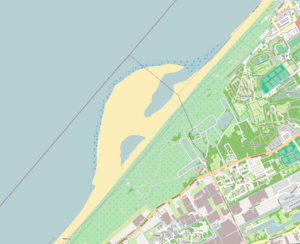
Sand engine
Method for coastal protection
Distance: Approx. 3103 meters
Latitude and longitude: 52.0519,4.1836
The sand engine or sand motor (Dutch: zandmotor) is a type of beach nourishment where a large volume of sediment is added to a coast. The natural forces of wind, waves and tides then distribute the sand along the coast over many years, preventing the need for repetitive beach nourishment. The method is expected to be more cost effective and also reduces the repeated ecological disturbances caused by replenishment.

Polanen Castle
Castle in the Netherlands
Distance: Approx. 1565 meters
Latitude and longitude: 52.030491,4.195978
Polanen Castle was a castle located in today's Monster, South Holland in the Netherlands. The ancestral home of the Polanen family, it suffered a siege in 1351 and was demolished in 1394. It was replaced by a small manor somewhat to the south.
Weather in this IP's area
overcast clouds
15 Celsius
15 Celsius
14 Celsius
15 Celsius
1013 hPa
92 %
1013 hPa
1012 hPa
10000 meters
1.54 m/s
210 degree
100 %
08:15:20
18:40:45