Country:
 Netherlands
Region:
City:
Latitude and Longitude:
Time Zone:
Postal Code:
IP information under different IP Channel
ip-api
Country
Region
City
ASN
Time Zone
ISP
Blacklist
Proxy
Latitude
Longitude
Postal
Route
IPinfo
Country
Region
City
ASN
Time Zone
ISP
Blacklist
Proxy
Latitude
Longitude
Postal
Route
MaxMind
Country
Region
City
ASN
Time Zone
ISP
Blacklist
Proxy
Latitude
Longitude
Postal
Route
Luminati
Country
NLRegion
zh
City
schiedam
ASN
Time Zone
Europe/Amsterdam
ISP
DELTA Fiber Nederland B.V.
Latitude
Longitude
Postal
db-ip
Country
Region
City
ASN
Time Zone
ISP
Blacklist
Proxy
Latitude
Longitude
Postal
Route
ipdata
Country
Region
City
ASN
Time Zone
ISP
Blacklist
Proxy
Latitude
Longitude
Postal
Route
Popular places and events near this IP address
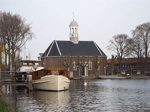
Uithoorn
Municipality in North Holland, Netherlands
Distance: Approx. 895 meters
Latitude and longitude: 52.23333333,4.83333333
Uithoorn (Dutch pronunciation: [œytˈɦoːr(ə)n] ) is a municipality and a town in the Netherlands, in the province of North Holland.

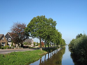
De Hoef, Utrecht
Village in Utrecht, Netherlands
Distance: Approx. 2944 meters
Latitude and longitude: 52.20972222,4.81472222
De Hoef is a village in the Dutch province of Utrecht. It is a part of the municipality of De Ronde Venen, and lies about 13 km northeast of Alphen aan den Rijn. Flowing through the village is a meandering river called "de Kromme Mijdrecht", the width of which varies between about 8 and 35 metres.

Amstelhoek
Village in Utrecht, Netherlands
Distance: Approx. 1099 meters
Latitude and longitude: 52.23111111,4.835
Amstelhoek is a village in the Dutch province of Utrecht. It is in the municipality of De Ronde Venen, about 3 km (1.9 mi) northwest of Mijdrecht. Amstelhoek lies on the river Amstel, directly across from Uithoorn.

Vrouwenakker
Hamlet in South Holland, Netherlands
Distance: Approx. 2670 meters
Latitude and longitude: 52.22805556,4.78388889
Vrouwenakker is a village in the Netherlands, about 12 km southeast of Hoofddorp. It lies largely in the municipality of Nieuwkoop (formerly Liemeer), in the province of South Holland, but a small part lies in the municipality of Uithoorn, in North Holland. Until 1989 Vrouwenakker was part of the municipality of Mijdrecht, but was then rearranged into the municipality of Liemeer after the amalgamation of Mijdrecht and surrounding municipalities.
Waverveen
Village in Utrecht, Netherlands
Distance: Approx. 1099 meters
Latitude and longitude: 52.23111111,4.835
Waverveen is a village in the Dutch province of Utrecht. It is located in the municipality of De Ronde Venen, 3 km west of Vinkeveen. Waverveen was a separate municipality until 1841, when it was merged with Vinkeveen to form the municipality of Vinkeveen en Waverveen.
Thamen
Distance: Approx. 1291 meters
Latitude and longitude: 52.236237,4.839832
Thamen is a former village in the Dutch province of North Holland. It was located north of Uithoorn. Thamen was a separate municipality until 1820, when it was merged with Uithoorn.

De Kwakel
Place in North Holland, Netherlands
Distance: Approx. 2122 meters
Latitude and longitude: 52.24083333,4.79083333
The Kwakel is a village in the municipality of Uithoorn, North Holland, the Netherlands, near the border with South Holland. Having 3880 inhabitants in 2006, it's close to Kudelstaart and Aalsmeer.

Nes aan de Amstel
Village in North Holland, Netherlands
Distance: Approx. 4277 meters
Latitude and longitude: 52.25916667,4.87083333
Nes aan de Amstel (Dutch pronunciation: [ˈnɛs aːn də ˈʔɑmstəl]) is a village in the municipality of Amstelveen in the province of North Holland, Netherlands. The village's name indicates that it is located on the Amstel; it is situated on the edge of the Rond Hoep polder.

Fort near De Kwakel
Fort located in De Kwakel village, Netherlands
Distance: Approx. 2129 meters
Latitude and longitude: 52.236944,4.789722
The Fort bij De Kwakel is a fort that is part of the Stelling van Amsterdam. It's located in the village of De Kwakel. It's one of four forts that form the linie Kudelstaart - Uithoorn.

Westwijk tram stop
Tram station in Amstelveen, Netherlands
Distance: Approx. 4341 meters
Latitude and longitude: 52.27444444,4.83055556
Westwijk is a tram stop serving the neighborhood of Westwijk in the city of Amstelveen, Netherlands. It serves tram line 25, dubbed the Amsteltram, which opened officially on 13 December 2020, unofficially 4 days earlier on 9 December. It used to be the southern terminus of the line until the opening of the extension to Uithoorn Centrum on 21 July 2024.
Chemische Industrie Uithoorn
Distance: Approx. 1562 meters
Latitude and longitude: 52.23981,4.84291
Chemische Industrie Uithoorn (Cindu, later Cindu Chemicals) was a chemical company in Uithoorn, Netherlands, specialising in processing coal tar. The company was founded in 1922 as Teerbedrijf Uithoorn (TEBU), and operated under a number of company names. It was acquired by Koppers in 2010 and renamed Koppers Netherlands.
FC Aalsmeer
Dutch football club
Distance: Approx. 3966 meters
Latitude and longitude: 52.25488,4.77166
FC Aalsmeer is an association football club from Aalsmeer, Netherlands. The club was founded on Augustus 1, 2014 through a merger of VV Aalsmeer and RKAV Aalsmeer. The two clubs had already partially merged in 2010 combining their youth football departments as Young Aalsmeer United.
Weather in this IP's area
few clouds
21 Celsius
21 Celsius
20 Celsius
22 Celsius
1008 hPa
63 %
1008 hPa
1009 hPa
10000 meters
6.71 m/s
200 degree
20 %
07:04:14
20:12:44