Country:
 Netherlands
Region:
City:
Latitude and Longitude:
Time Zone:
Postal Code:
IP information under different IP Channel
ip-api
Country
Region
City
ASN
Time Zone
ISP
Blacklist
Proxy
Latitude
Longitude
Postal
Route
IPinfo
Country
Region
City
ASN
Time Zone
ISP
Blacklist
Proxy
Latitude
Longitude
Postal
Route
MaxMind
Country
Region
City
ASN
Time Zone
ISP
Blacklist
Proxy
Latitude
Longitude
Postal
Route
Luminati
Country
NLRegion
nb
City
oudgastel
ASN
Time Zone
Europe/Amsterdam
ISP
DELTA Fiber Nederland B.V.
Latitude
Longitude
Postal
db-ip
Country
Region
City
ASN
Time Zone
ISP
Blacklist
Proxy
Latitude
Longitude
Postal
Route
ipdata
Country
Region
City
ASN
Time Zone
ISP
Blacklist
Proxy
Latitude
Longitude
Postal
Route
Popular places and events near this IP address

Driel
Village in Gelderland, Netherlands
Distance: Approx. 2322 meters
Latitude and longitude: 51.96666667,5.81666667
Driel is a village in the municipality of Overbetuwe, approximately four kilometers southwest of Arnhem on the south bank of the Rhine, in the Netherlands.

Wolfheze
Village in Gelderland, Netherlands
Distance: Approx. 2945 meters
Latitude and longitude: 52.005,5.79166667
Wolfheze is a village in the Dutch province of Gelderland. It is located in the municipality of Renkum, 10 km northwest of the city of Arnhem.

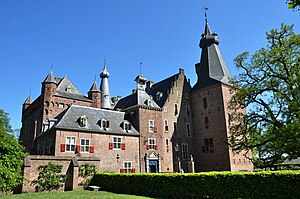
Doorwerth Castle
Castle in the Netherlands
Distance: Approx. 1325 meters
Latitude and longitude: 51.9667,5.7888
Doorwerth Castle (Dutch: Kasteel Doorwerth) is a medieval castle situated on the river Rhine near the city of Arnhem, Netherlands.
Doorwerth
Place in Gelderland, Netherlands
Distance: Approx. 441 meters
Latitude and longitude: 51.97805556,5.79527778
Doorwerth is a village in the eastern Netherlands. It is located in the municipality of Renkum, Gelderland, about 8 km west of Arnhem and about 100 km southeast of Amsterdam.

A50 motorway (Netherlands)
Motorway in the Netherlands
Distance: Approx. 1736 meters
Latitude and longitude: 51.97,5.76777778
A50, the section of Rijksweg 50 that is constructed as controlled-access highway, is a north–south motorway in the Netherlands, running from Eindhoven in the province of North Brabant, northwards passing by the cities of Oss, Nijmegen, Arnhem and Apeldoorn, to its northern terminus in the province of Gelderland near the city of Zwolle. The highway is maintained by Rijkswaterstaat.
Wolfheze railway station
Railway station in the Netherlands
Distance: Approx. 2987 meters
Latitude and longitude: 52.00527778,5.79361111
Wolfheze is a railway station located in Wolfheze, Netherlands. The station opened in 1845 and is on the Amsterdam–Arnhem railway. The train service are operated by Nederlandse Spoorwegen.
De Kromme Dissel
Restaurant in Heelsum, Netherlands
Distance: Approx. 2183 meters
Latitude and longitude: 51.98417778,5.758375
De Kromme Dissel is a restaurant located in Heelsum in the Netherlands. It is a fine dining restaurant that was awarded one Michelin stars in the period 1971 to present. GaultMillau awarded the restaurant 16.0 points.
Beaulieu, Doorwerth Castle
Restaurant in Doorwerth, Netherlands
Distance: Approx. 1390 meters
Latitude and longitude: 51.96611111,5.78861111
Beaulieu was a restaurant in Doorwerth Castle in Doorwerth, the Netherlands. It was a fine dining restaurant that was awarded one Michelin star in 1966 and retained that rating until 1979. Head chef was Albert Emke.
Heelsum
Village in Gelderland, Netherlands
Distance: Approx. 2528 meters
Latitude and longitude: 51.98222222,5.7525
Heelsum is a village in the Dutch province of Gelderland. It is located in the municipality of Renkum, west of Arnhem. Part of the Battle of Arnhem was fought in and around Heelsum.

Duizendjarige den
Distance: Approx. 2200 meters
Latitude and longitude: 51.9959,5.8044
The Duizendjarige den was a scots pine (Pinus sylvestris) in the Wolfhezerbossen near Wolfheze, Netherlands. The tree fell down on 28 May 2006. It is estimated that the tree was nearly four hundred years old.

Heveadorp
Village in Gelderland, Netherlands
Distance: Approx. 1475 meters
Latitude and longitude: 51.97502,5.80961
Heveadorp is a village near Doorwerth in the municipality of Renkum, Gelderland, the Netherlands. The village is situated in a valley surrounded by forest. The creek Seelbeek runs through the village.
Dorenweerd College
School in Gelderland, Netherlands
Distance: Approx. 935 meters
Latitude and longitude: 51.985166,5.797396
The Dorenweerd College (formerly Duno College) is a school in the Forests of Doorwerth in the Dutch province Gelderland. Education in Dutch and English is offered on 3 levels. The College was founded in 1999 in a merging of several institutes within the City of Renkum.
Weather in this IP's area
mist
14 Celsius
14 Celsius
13 Celsius
15 Celsius
1013 hPa
96 %
1013 hPa
1007 hPa
3200 meters
1.03 m/s
75 %
08:08:48
18:34:23