Country:
 Netherlands
Region:
City:
Latitude and Longitude:
Time Zone:
Postal Code:
IP information under different IP Channel
ip-api
Country
Region
City
ASN
Time Zone
ISP
Blacklist
Proxy
Latitude
Longitude
Postal
Route
IPinfo
Country
Region
City
ASN
Time Zone
ISP
Blacklist
Proxy
Latitude
Longitude
Postal
Route
MaxMind
Country
Region
City
ASN
Time Zone
ISP
Blacklist
Proxy
Latitude
Longitude
Postal
Route
Luminati
Country
NLRegion
ge
City
scherpenzeel
ASN
Time Zone
Europe/Amsterdam
ISP
DELTA Fiber Nederland B.V.
Latitude
Longitude
Postal
db-ip
Country
Region
City
ASN
Time Zone
ISP
Blacklist
Proxy
Latitude
Longitude
Postal
Route
ipdata
Country
Region
City
ASN
Time Zone
ISP
Blacklist
Proxy
Latitude
Longitude
Postal
Route
Popular places and events near this IP address

Dordrecht
City and municipality in South Holland, Netherlands
Distance: Approx. 2540 meters
Latitude and longitude: 51.79583333,4.67833333
Dordrecht (Dutch: [ˈdɔrdrɛxt] ), historically known in English as Dordt (still colloquially used in Dutch, pronounced [dɔrt] ) or Dort, is a city and municipality in the Western Netherlands, located in the province of South Holland. It is the province's fifth-largest city after Rotterdam, The Hague, Leiden, and Zoetermeer, with a population of 119,115. The municipality covers the entire Dordrecht Island, also often called Het Eiland van Dordt ("the Island of Dordt"), bordered by the rivers Oude Maas, Beneden Merwede, Nieuwe Merwede, Hollands Diep, and Dordtsche Kil.

's-Gravendeel
Village in South Holland, Netherlands
Distance: Approx. 4189 meters
Latitude and longitude: 51.78333333,4.61666667
's-Gravendeel (Dutch pronunciation: [ˌsxraːvə(n)ˈdeːl] ) is a village and former municipality in the western Netherlands, in the province of South Holland. 's-Gravendeel is on the eastern side of Hoeksche Waard Island on the river Dordtsche Kil. It is connected to Dordrecht by means of the Kil Tunnel.

Dordtsche Kil
River in the Netherlands
Distance: Approx. 3458 meters
Latitude and longitude: 51.76583333,4.62638889
The Dordtse Kil (pre-1947 spelling: Dordtsche Kil) is a short river in South Holland in the Netherlands. The river is tidal and forms the connection between the Oude Maas river and the Hollands Diep. The river is for most part artificial in origin, since it has been a relatively small tidal creek until the 19th century.
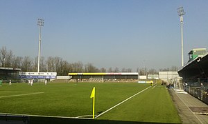
Stadion Krommedijk
Distance: Approx. 3411 meters
Latitude and longitude: 51.8025,4.68916667
The Stadion Krommedijk (known as the Matchoholic Stadion for sponsorship reasons) is a multi-purpose all-seater stadium in Dordrecht, South Holland, Netherlands. It is currently mostly used for football matches and is the home stadium of FC Dordrecht. The stadium is able to hold 4,100 spectators, and was built in 1948.

Dubbeldam
Former village and municipality in South Holland, Netherlands
Distance: Approx. 4163 meters
Latitude and longitude: 51.78333333,4.73333333
Dubbeldam is a former village in the Dutch province of South Holland. It was located to the east of the city of Dordrecht. It is now a part of that city.
De Mijl
Hamlet in South Holland, Netherlands
Distance: Approx. 4006 meters
Latitude and longitude: 51.80416667,4.64583333
De Mijl is a former hamlet in the Dutch province of South Holland. It was located about 2 km southwest of the city of Dordrecht, on the Oude Maas river. De Mijl was a separate municipality from 1817 to 1857, when it became part of Dubbeldam.

Wieldrecht
Place in South Holland, Netherlands
Distance: Approx. 2076 meters
Latitude and longitude: 51.78333333,4.65
Wieldrecht is a small village in the Dutch province of South Holland. It is located about 4 km southwest of the city of Dordrecht, on the Kil River. Wieldrecht was a separate municipality between 1817 and 1857, when it became part of Dubbeldam.

Dordrecht railway station
Railway station in the Netherlands
Distance: Approx. 3863 meters
Latitude and longitude: 51.8075,4.66777778
Dordrecht is a railway station in Dordrecht, Netherlands located on the Breda–Rotterdam railway and the Elst–Dordrecht railway. The station was opened on 1 January 1872, when the railway line between Rotterdam and Antwerp was opened. On 16 July 1885, the railway line from Dordrecht to Gorinchem was opened.

Dordrecht Zuid railway station
Railway station in the Netherlands
Distance: Approx. 1869 meters
Latitude and longitude: 51.78972222,4.67138889
Dordrecht Zuid is a railway station in the south of Dordrecht, Netherlands, located on the Breda–Rotterdam railway between Lage Zwaluwe and Dordrecht. Trains running between Den Haag Centraal, Roosendaal and Breda stop at this station. The current railway building was constructed in the early 1970s.

Dordrecht Stadspolders railway station
Railway station in Dordrecht, Netherlands
Distance: Approx. 4297 meters
Latitude and longitude: 51.80194444,4.71666667
Dordrecht Stadspolders is a railway station in Dordrecht, Netherlands. The station is located on the MerwedeLingelijn between Dordrecht and Geldermalsen (part of the Elst–Dordrecht railway). It was opened on 27 May 1990 and initially had only one track.

Drechttunnel
Tunnel in the Netherlands
Distance: Approx. 4460 meters
Latitude and longitude: 51.8094,4.6478
The Drechttunnel is an underground motorway tunnel in Netherlands. It connects Dordrecht and Zwijndrecht. The tunnel has 4 tubes including 8 lanes.

Dordrecht Sugar Factory
Distance: Approx. 4296 meters
Latitude and longitude: 51.808495,4.650348
Dordrecht Sugar Factory was an early Dutch beet sugar factory, built in 1861. It closed down in 1909 and has since been completely demolished.
Weather in this IP's area
light rain
14 Celsius
14 Celsius
14 Celsius
15 Celsius
1013 hPa
94 %
1013 hPa
1013 hPa
10000 meters
0.89 m/s
1.79 m/s
252 degree
89 %
08:12:53
18:39:12