Country:
 Netherlands
Region:
City:
Latitude and Longitude:
Time Zone:
Postal Code:
IP information under different IP Channel
ip-api
Country
Region
City
ASN
Time Zone
ISP
Blacklist
Proxy
Latitude
Longitude
Postal
Route
IPinfo
Country
Region
City
ASN
Time Zone
ISP
Blacklist
Proxy
Latitude
Longitude
Postal
Route
MaxMind
Country
Region
City
ASN
Time Zone
ISP
Blacklist
Proxy
Latitude
Longitude
Postal
Route
Luminati
Country
NLRegion
ge
City
scherpenzeel
ASN
Time Zone
Europe/Amsterdam
ISP
DELTA Fiber Nederland B.V.
Latitude
Longitude
Postal
db-ip
Country
Region
City
ASN
Time Zone
ISP
Blacklist
Proxy
Latitude
Longitude
Postal
Route
ipdata
Country
Region
City
ASN
Time Zone
ISP
Blacklist
Proxy
Latitude
Longitude
Postal
Route
Popular places and events near this IP address

Goirle
Municipality in North Brabant, Netherlands
Distance: Approx. 5238 meters
Latitude and longitude: 51.51666667,5.06666667
Goirle (pronounced [ˈɣoːrlə] ) is a municipality and town in the southern Netherlands, in the province of North Brabant. Part of the suburban area of the city of Tilburg, it shares with it its phone area code and public transport system. The municipality also includes the villages of Breehees and Riel.
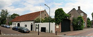
Hilvarenbeek
Municipality in North Brabant, Netherlands
Distance: Approx. 1091 meters
Latitude and longitude: 51.48333333,5.13333333
Hilvarenbeek (Dutch pronunciation: [ɦɪlˌvaːrə(m)ˈbeːk] ) is a municipality and a town in the south of the Netherlands, along the border with Belgium. The biggest tourist attraction is called Beekse Bergen, consisting of a safari park, amusement park/playground, holiday bungalow park, and camping parks. In the centre of the town the Sint-Petrus'-Banden is a Gothic church from the 14th and 15th centuries.
De Koningshoeven Brewery
Dutch Trappist brewery
Distance: Approx. 5629 meters
Latitude and longitude: 51.54355,5.12661667
De Koningshoeven Brewery (Brouwerij de Koningshoeven) is a Dutch Trappist brewery founded in 1884 within the walls of Koningshoeven Abbey in Berkel-Enschot (near Tilburg).

Willem II College
Distance: Approx. 6298 meters
Latitude and longitude: 51.5413,5.0845
Koning Willem II College is a school in Tilburg in the Netherlands. It was established in 1866 and is named after King Willem II. The school was founded in the former royal palace in Tilburg, the present City Hall, of which the construction was commissioned by King William II himself. In 1934 the school moved from the former palace to the new location a new and much bigger building at the Ringbaan Oost in Tilburg.
Gorp, Netherlands
Distance: Approx. 3551 meters
Latitude and longitude: 51.48333333,5.08333333
Gorp is a hamlet in the municipality of Hilvarenbeek, in the south of the Netherlands near its border with Belgium. Once historically separate from Hilvarenbeek, it has become a de facto neighborhood of the larger town. The Gorp forest area was turned into a "fairytale forest" during the annual children's holiday week in August 2019.

Diessen
Village in North Brabant, Netherlands
Distance: Approx. 3647 meters
Latitude and longitude: 51.47388889,5.17472222
Diessen is a village in the Dutch province of North Brabant. It is located in the municipality of Hilvarenbeek.
Heikant, Hilvarenbeek
Hamlet in Hilvarenbeek, the Netherlands
Distance: Approx. 6252 meters
Latitude and longitude: 51.4475,5.18472222
Heikant is a hamlet in the municipality of Hilvarenbeek, in the Dutch province of North Brabant. It is located about 5 km south of Diessen.

Safaripark Beekse Bergen
Wildlife zoo in the Netherlands
Distance: Approx. 3326 meters
Latitude and longitude: 51.51944444,5.10944444
Safaripark Beekse Bergen is the largest wildlife zoo of the Benelux region and provides a home to approximately 1,250 animals from over 150 species, varying from small mammals to large birds. It is located between the cities of Tilburg and Hilvarenbeek in the south of the Netherlands. The visitors can for instance watch zebras and giraffes on the spacious savannahs.
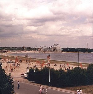
Speelland Beekse Bergen
Distance: Approx. 3806 meters
Latitude and longitude: 51.527,5.125
Speelland Beekse Bergen is an amusement park and playground near Hilvarenbeek, Netherlands. It is a part of the Beekse Bergen group, which also owns Safaripark Beekse Bergen. The park has been a part of Libéma Exploitatie since 1987.

Esbeek
Village in North Brabant, Netherlands
Distance: Approx. 2944 meters
Latitude and longitude: 51.46666667,5.13333333
Esbeek is a village with 1,200 inhabitants. It is one of the six church villages of the municipality of Hilvarenbeek, which has a total of 15,000 inhabitants. Esbeek is located on the high sandy soils in the south of the Netherlands in the province of North Brabant, on the border with Belgium.
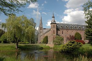
Koningshoeven Abbey
Monastery in North Brabant, Netherlands
Distance: Approx. 5625 meters
Latitude and longitude: 51.54361111,5.12972222
Koningshoeven Abbey (Dutch: Abdij Koningshoeven, Abdij Onze Lieve Vrouw van Koningshoeven) is a monastery of the Trappists (Order of the Cistercians of the Strict Observance) founded in 1881 in Berkel-Enschot in North Brabant, the Netherlands.

Baarschot, Hilvarenbeek
Hamlet in North Brabant, Netherlands
Distance: Approx. 5970 meters
Latitude and longitude: 51.45,5.18333333
Baarschot (Dutch pronunciation: [ˈbaːr.sxɔt]; Brabantian: Baorschot) is a hamlet in the municipality of Hilvarenbeek in the province of North Brabant in the Netherlands. In contrast to many other hamlets in the Netherlands, Baarschot does have an official built-up area and thus also standard blue town signs. Administratively, it is part of Diessen.
Weather in this IP's area
mist
15 Celsius
15 Celsius
14 Celsius
15 Celsius
1013 hPa
98 %
1013 hPa
1011 hPa
2900 meters
1.54 m/s
240 degree
75 %
08:10:34
18:37:52