Country:
 Netherlands
Region:
City:
Latitude and Longitude:
Time Zone:
Postal Code:
IP information under different IP Channel
ip-api
Country
Region
City
ASN
Time Zone
ISP
Blacklist
Proxy
Latitude
Longitude
Postal
Route
IPinfo
Country
Region
City
ASN
Time Zone
ISP
Blacklist
Proxy
Latitude
Longitude
Postal
Route
MaxMind
Country
Region
City
ASN
Time Zone
ISP
Blacklist
Proxy
Latitude
Longitude
Postal
Route
Luminati
Country
NLRegion
ge
City
nijmegen
ASN
Time Zone
Europe/Amsterdam
ISP
DELTA Fiber Nederland B.V.
Latitude
Longitude
Postal
db-ip
Country
Region
City
ASN
Time Zone
ISP
Blacklist
Proxy
Latitude
Longitude
Postal
Route
ipdata
Country
Region
City
ASN
Time Zone
ISP
Blacklist
Proxy
Latitude
Longitude
Postal
Route
Popular places and events near this IP address
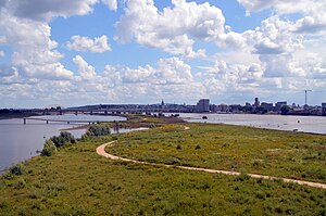
Nijmegen
City and municipality in Gelderland, Netherlands
Distance: Approx. 1256 meters
Latitude and longitude: 51.8475,5.8625
Nijmegen (Dutch: [ˈnɛiˌmeːɣə(n)] ; Nijmeegs: Nimwèège [ˈnɪmβ̞ɛːçə]) is the largest city in the Dutch province of Gelderland and the tenth largest of the Netherlands as a whole. Located on the Waal River close to the German border, Nijmegen is one of the oldest cities in the Netherlands and the first to be recognized as such in Roman times. In 2005, it celebrated 2,000 years of existence.

Valkhof Museum
Distance: Approx. 861 meters
Latitude and longitude: 51.846,5.871
The Valkhof Museum (Dutch: Museum Het Valkhof) is an archaeology and art museum in Nijmegen, Netherlands. The museum has existed since 1999, created as a merger between the G. M. Kam museum of archaeology and the Commanderie van St. Jan museum of classical and modern art.
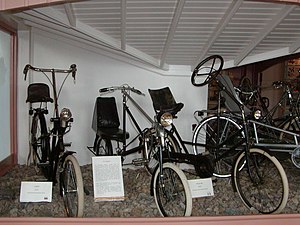
Velorama
Distance: Approx. 1193 meters
Latitude and longitude: 51.84888889,5.86972222
The Velorama (Dutch: Nationaal Fietsmuseum Velorama) is the only bicycle museum in the Netherlands. It is located along the Waal River in the city of Nijmegen. The museum was founded in 1981 from the private collection of G.F. Moed.

Nijmegen railway station
Railway station in Nijmegen, Netherlands
Distance: Approx. 1532 meters
Latitude and longitude: 51.84333333,5.8525
Nijmegen railway station is the main railway station of Nijmegen in Gelderland, Netherlands. It was opened on 9 August 1865 and is located on the Tilburg–Nijmegen railway, Nijmegen–Venlo railway and the Arnhem–Nijmegen railway. It was extensively rebuilt after the war since the original station was severely damaged by a US bombing raid in February 1944 and during Operation Market Garden in September 1944.

Nijmegen Heyendaal railway station
Railway station in the Netherlands
Distance: Approx. 1331 meters
Latitude and longitude: 51.82694444,5.86777778
Nijmegen Heyendaal is a railway station located near Radboud University in the southeast of Nijmegen, the Netherlands. The station was opened on 28 May 1972 and is located on the Maaslijn (Nijmegen–Venlo). The train services are operated by Arriva.

Waalbrug
Bridge in Nijmegen, Netherlands
Distance: Approx. 1419 meters
Latitude and longitude: 51.85111111,5.87166667
The Waalbrug is an arch bridge over the Waal River in Nijmegen, Gelderland, the Netherlands. The full length of the Waalbrug is 604 metres (1,982 ft), the middle of the arch being about 65 metres (213 ft) high. The arch itself is 244.1 metres (801 ft) long and was the longest arch in Europe at the time of construction.

Stratemakerstoren
Distance: Approx. 1163 meters
Latitude and longitude: 51.84861111,5.86972222
The Stratemakerstoren is an early 16th-century bastion on the Waalkade in the Dutch town Nijmegen. It is a rijksmonument (national heritage site) and since 1995, it housed a museum. This was closed in April 2015, for major reconstruction.

Concertgebouw de Vereeniging
Concert hall in Nijmegen, Netherlands
Distance: Approx. 920 meters
Latitude and longitude: 51.84138889,5.86083333
Concertgebouw de Vereeniging is a concert hall located in Nijmegen, Netherlands. The facility officially opened in 1915 and is built in a mixture of Art Nouveau and Art Deco styles. It has a capacity of 1,450 seats (or 1,800 standing people during pop concerts), and is renowned for its outstanding acoustics for orchestral music.
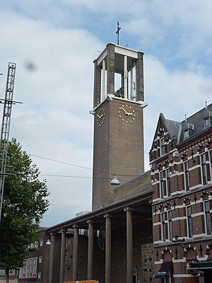
St Peter Canisius Church, Nijmegen
Distance: Approx. 998 meters
Latitude and longitude: 51.844836,5.86319
St Peter Canisius Church (Dutch: Sint-Petrus Canisiuskerk), also known as Molenstraatkerk, is a Roman Catholic Parish church in Nijmegen, Gelderland, Netherlands. It is situated on Molenstraat in the centre of the city. It is run by the Society of Jesus and is in the Diocese of 's-Hertogenbosch.

Karel de Grote College
Waldorf/steiner education school
Distance: Approx. 648 meters
Latitude and longitude: 51.8403,5.8644
Karel de Grote College is a Dutch Waldorf school named after Charlemagne or Charles the Great, King of the Franks. The school is located near the centre of Nijmegen and has around 750 students, most of whom are from Nijmegen but a large number from outer cities and towns such as Arnhem, Cuijk and Wageningen also find their way to this school.

Grote Broek
Self-managed political project in Nijmegen, the Netherlands
Distance: Approx. 783 meters
Latitude and longitude: 51.8438,5.866
De Grote Broek (English: The Big Trousers) is a legalised squat and self-managed social centre in central Nijmegen in the Netherlands. It was occupied in 1984 and legalised from 2002 onwards. It spans two sides of a city block and has entrances on both Van Broeckhuysenstraat and Tweede Walstraat.

Lindenberg Nijmegen Culture House
Distance: Approx. 1171 meters
Latitude and longitude: 51.84852,5.868633
The Lindenberg Nijmegen Culture House, founded in 1972, was a project opened by the Netherlands Minister of Culture, Piet Engels. It is a cultural house (theatre) in Nijmegen, Netherlands, on the Ridderstraat next to the Valkhof Museum. The Lindenberg operates theatre programs, hosts performances, hosts education courses, and has a cafe.
Weather in this IP's area
scattered clouds
14 Celsius
13 Celsius
12 Celsius
15 Celsius
1027 hPa
84 %
1027 hPa
1022 hPa
10000 meters
0.89 m/s
2.68 m/s
360 degree
33 %
07:14:56
19:47:04