Country:
 Netherlands
Region:
City:
Latitude and Longitude:
Time Zone:
Postal Code:
IP information under different IP Channel
ip-api
Country
Region
City
ASN
Time Zone
ISP
Blacklist
Proxy
Latitude
Longitude
Postal
Route
IPinfo
Country
Region
City
ASN
Time Zone
ISP
Blacklist
Proxy
Latitude
Longitude
Postal
Route
MaxMind
Country
Region
City
ASN
Time Zone
ISP
Blacklist
Proxy
Latitude
Longitude
Postal
Route
Luminati
Country
NLRegion
ge
City
scherpenzeel
ASN
Time Zone
Europe/Amsterdam
ISP
DELTA Fiber Nederland B.V.
Latitude
Longitude
Postal
db-ip
Country
Region
City
ASN
Time Zone
ISP
Blacklist
Proxy
Latitude
Longitude
Postal
Route
ipdata
Country
Region
City
ASN
Time Zone
ISP
Blacklist
Proxy
Latitude
Longitude
Postal
Route
Popular places and events near this IP address

Amerongen
Town in the province of Utrecht, Netherlands
Distance: Approx. 2556 meters
Latitude and longitude: 52.0025,5.46083333
Amerongen (Dutch pronunciation: [ˈaːmərɔŋə(n)] ) is a town in the municipality of Utrechtse Heuvelrug in the province of Utrecht, Netherlands, on the border of the Utrecht Hill Ridge. It lies about 7 km (4.3 mi) southwest of Veenendaal (10.5 km or 6.5 mi by road). The landscape rises from the flat water meadows of the Nederrijn (Lower Rhine) to the Utrecht Hill Ridge ("Utrechtse Heuvelrug").

Leersum
Town in the province of Utrecht, Netherlands
Distance: Approx. 890 meters
Latitude and longitude: 52.01666667,5.43333333
Leersum is a town in the municipality of Utrechtse Heuvelrug in the Dutch province of Utrecht. It lies about 7 km (4.3 mi) east of Doorn and 9 km (5.5 mi) west of Veenendaal. In 2001, the town of Leersum had 6013 inhabitants.

Maarsbergen
Village in Utrecht, Netherlands
Distance: Approx. 5448 meters
Latitude and longitude: 52.0575,5.40527778
Maarsbergen is a settlement in the Dutch province of Utrecht. It is a part of the municipality of Utrechtse Heuvelrug, and lies about 18 km east of Utrecht.

Eck en Wiel
Village in Gelderland, Netherlands
Distance: Approx. 5035 meters
Latitude and longitude: 51.9692,5.4567
Eck en Wiel is a village in the Dutch province of Gelderland. It is a part of the municipality of Buren, and lies about 9 km southwest of Veenendaal.

Maurik
Town in Gelderland, Netherlands
Distance: Approx. 5590 meters
Latitude and longitude: 51.96,5.42361111
Maurik is a town in the Dutch province of Gelderland. It is a part of the municipality of Buren, and lies about 8 km north of Tiel.

Darthuizen
Hamlet in Utrecht, Netherlands
Distance: Approx. 1911 meters
Latitude and longitude: 52.0125,5.39805556
Darthuizen is a hamlet in the Dutch municipality of Utrechtse Heuvelrug. From 1818 to 1857, Darthuizen was a separate municipality. On 8 June 1857, it merged into the municipality of Leersum.

Breedeveen
Hamlet in Utrecht, Netherlands
Distance: Approx. 1589 meters
Latitude and longitude: 52.02361111,5.41777778
Breedeveen is a hamlet in the municipality Utrechtse Heuvelrug, in the Dutch province Utrecht. It lies in a forest north of the village of Leersum, on the road from Leersum to Woudenberg. The hamlet was first mentioned in 1899 Breedeveen, and means "wide bog".

County of Buren
Historic state
Distance: Approx. 4886 meters
Latitude and longitude: 51.96666667,5.41666667
The Buren County was a territory situated in what is now the Dutch province of Gelderland. It was an independent county until the establishment of the Batavian Republic in 1795. Although it was not formally part of the United Provinces, in practice it was governed by it.
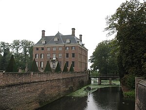
Amerongen Castle
2011 Dutch film
Distance: Approx. 2786 meters
Latitude and longitude: 51.99527778,5.45833333
Amerongen Castle (Dutch: Kasteel Amerongen [kɑˌsteːl ˈaːmɛrɔŋə(n)]) is a castle in Amerongen, Utrechtse Heuvelrug, Netherlands. It was built between 1674 and 1680, on the site of a medieval castle that had been burned down by the French in 1673. The gardens still contain historic elements such as a conservatory dating from the 1890s.

Utrechtse Heuvelrug National Park
National park in the Netherlands
Distance: Approx. 1820 meters
Latitude and longitude: 52.025,5.437
Utrechtse Heuvelrug National Park is a national park in the Dutch province of Utrecht. It covers the southern part of the Utrecht Hill Ridge. When it was founded in 2003 the park covered 6,000 ha (15,000 acres) of heathlands, shifting sands, forests, grass lands and floodplains.
Overlangbroek
Distance: Approx. 4169 meters
Latitude and longitude: 51.98333333,5.38333333
Overlangbroek is a former village in the Dutch province of Utrecht. It is a part of the municipality of Wijk bij Duurstede, and lies about 11 km southeast of Zeist. The village officially merged with Nederlangbroek into Langbroek in 1978.

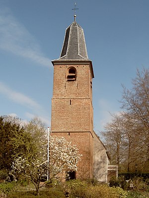
Andrieskerk
Distance: Approx. 2804 meters
Latitude and longitude: 51.998,5.4615
The Andrieskerk ("St. Andrew's church") is a nowadays Protestant church in the Dutch village of Amerongen. The church's history spans around seven centuries, beginning in the end of the 13th century, when everybody in western Europe had to be Roman Catholic.
Weather in this IP's area
light rain
14 Celsius
14 Celsius
13 Celsius
15 Celsius
1013 hPa
94 %
1013 hPa
1012 hPa
10000 meters
2.1 m/s
2.7 m/s
275 degree
85 %
08:10:18
18:35:47