Country:
 Netherlands
Region:
City:
Latitude and Longitude:
Time Zone:
Postal Code:
IP information under different IP Channel
ip-api
Country
Region
City
ASN
Time Zone
ISP
Blacklist
Proxy
Latitude
Longitude
Postal
Route
IPinfo
Country
Region
City
ASN
Time Zone
ISP
Blacklist
Proxy
Latitude
Longitude
Postal
Route
MaxMind
Country
Region
City
ASN
Time Zone
ISP
Blacklist
Proxy
Latitude
Longitude
Postal
Route
Luminati
Country
NLRegion
nb
City
terheijden
ASN
Time Zone
Europe/Amsterdam
ISP
DELTA Fiber Nederland B.V.
Latitude
Longitude
Postal
db-ip
Country
Region
City
ASN
Time Zone
ISP
Blacklist
Proxy
Latitude
Longitude
Postal
Route
ipdata
Country
Region
City
ASN
Time Zone
ISP
Blacklist
Proxy
Latitude
Longitude
Postal
Route
Popular places and events near this IP address

Rat Verlegh Stadion
Multi-purpose stadium in Breda, Netherlands
Distance: Approx. 4806 meters
Latitude and longitude: 51.595,4.75027778
The Rat Verlegh Stadion (Dutch pronunciation: [ˌrɑt fərˈlɛx ˌstaːdijɔn]) is a multi-purpose stadium in Breda, Netherlands. The stadium is the home of the association football club NAC Breda (1996 to present). It was formerly known as FUJIFILM Stadium (1996–2003) and Mycom Stadium (2003–2006), named after two former NAC sponsors.

Prinsenbeek
Town in North Brabant, Netherlands
Distance: Approx. 4972 meters
Latitude and longitude: 51.6,4.71666667
Prinsenbeek is a village and a former municipality in the Dutch province North Brabant. The village is situated west of the motorway A16 (Rotterdam–Antwerp) and the TGV line Amsterdam–Paris. Prinsenbeek is a part of the municipality Breda, and it has 11,419 inhabitants (2005).

Made, Netherlands
Village in North Brabant, Netherlands
Distance: Approx. 5016 meters
Latitude and longitude: 51.67638889,4.7925
Made is a town in the Dutch province of North Brabant. It is located in the municipality of Drimmelen, about 10 km northeast of Breda.

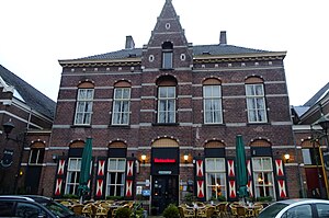
Terheijden
Village in North Brabant, Netherlands
Distance: Approx. 588 meters
Latitude and longitude: 51.64333333,4.75305556
Terheijden is a village in the Dutch province of North Brabant. It is located in the municipality of Drimmelen, about 6 km north of Breda.

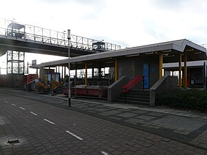
Breda railway station
Railway station in Netherlands
Distance: Approx. 5119 meters
Latitude and longitude: 51.595,4.78
Breda railway station is a railway station in Breda in North Brabant, Netherlands. It is situated on the Breda–Rotterdam railway, the Roosendaal–Breda railway and the Breda–Eindhoven railway.
Breda-Prinsenbeek railway station
Railway station in the Netherlands
Distance: Approx. 4290 meters
Latitude and longitude: 51.60527778,4.72166667
Breda-Prinsenbeek is a railway station in the city of Breda. It is located on the Breda–Rotterdam railway, parallel to the A16 motorway. The station serves the village of Prinsenbeek and the Breda city district Haagse Beemden.

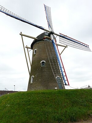
De Arend, Terheijden
Windmill in The Netherlands
Distance: Approx. 1055 meters
Latitude and longitude: 51.645811,4.745325
De Arend (English: The Eagle) is a windmill located on the Molenstraat 40 in Terheijden, Drimmelen, in the province of North Brabant, Netherlands. Built in 1742 the windmill functioned as a gristmill. The mill was built as a tower mill and its sails have a span of 24.80 meters.
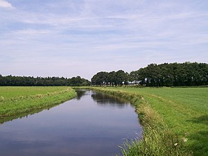
Aa of Weerijs
River in Belgium
Distance: Approx. 5203 meters
Latitude and longitude: 51.5926,4.7714
The Aa of Weerijs (Dutch pronunciation: [ˌaː ʔɔf ˈʋeːrɛis], lit. 'Aa or Weerijs') is a river in Belgium and Netherlands, where it arises from the confluence of the Great Aa (in Wuustwezel) and the Small Aa (in Brecht). In Breda (which means the broad Aa) it is the river in the canals of this city.
De Hoop, Den Hout
Dutch windmill
Distance: Approx. 4326 meters
Latitude and longitude: 51.656111,4.809689
De Hoop is a gristmill in Den Hout, Netherlands. The mill was built in 1837. In 1975, the owner sold the mill to the municipality, which had it restored in 1985.
Den Hout
Village in North Brabant, Netherlands
Distance: Approx. 4534 meters
Latitude and longitude: 51.65777778,4.81166667
Den Hout is a village in the Dutch province of North Brabant. It is located in the municipality of Oosterhout. The village was first mentioned in 1311 as "Rolinus dictus van den Houte", and means deciduous forest.
Hooge Zwaluwe
Village in North Brabant, Netherlands
Distance: Approx. 5055 meters
Latitude and longitude: 51.6833,4.7471
Hooge Zwaluwe is a village in the Dutch province of North Brabant. It is located in the municipality of Drimmelen, about 3.5 km north-west of Made.

Wagenberg
Village in North Brabant, Netherlands
Distance: Approx. 2937 meters
Latitude and longitude: 51.664,4.7461
Wagenberg is a village in the Dutch province of North Brabant. It is located in the municipality of Drimmelen. The village is located about 6 kilometres (3.7 mi) north of Breda.
Weather in this IP's area
broken clouds
20 Celsius
20 Celsius
19 Celsius
22 Celsius
1009 hPa
67 %
1009 hPa
1009 hPa
10000 meters
5.66 m/s
190 degree
75 %
07:05:12
20:12:18