Country:
 Netherlands
Region:
City:
Latitude and Longitude:
Time Zone:
Postal Code:
IP information under different IP Channel
ip-api
Country
Region
City
ASN
Time Zone
ISP
Blacklist
Proxy
Latitude
Longitude
Postal
Route
IPinfo
Country
Region
City
ASN
Time Zone
ISP
Blacklist
Proxy
Latitude
Longitude
Postal
Route
MaxMind
Country
Region
City
ASN
Time Zone
ISP
Blacklist
Proxy
Latitude
Longitude
Postal
Route
Luminati
Country
NLRegion
ze
City
kapelle
ASN
Time Zone
Europe/Amsterdam
ISP
DELTA Fiber Nederland B.V.
Latitude
Longitude
Postal
db-ip
Country
Region
City
ASN
Time Zone
ISP
Blacklist
Proxy
Latitude
Longitude
Postal
Route
ipdata
Country
Region
City
ASN
Time Zone
ISP
Blacklist
Proxy
Latitude
Longitude
Postal
Route
Popular places and events near this IP address

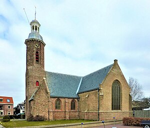
Kapelle
Municipality in Zeeland, Netherlands
Distance: Approx. 914 meters
Latitude and longitude: 51.48333333,3.95
Kapelle (Dutch pronunciation: [kaːˈpɛlə] ) is a municipality and a town in the southwestern Netherlands on Zuid-Beveland. In 2023 the municipality's population amounts to 13,051.

Canal through Zuid-Beveland
Canal in Netherlands
Distance: Approx. 2952 meters
Latitude and longitude: 51.4825,4.00416667
The Canal through Zuid-Beveland (Dutch: Kanaal door Zuid-Beveland) in the southwest Netherlands is the westernmost of two canals crossing the Zuid-Beveland peninsula. It connects the Western Scheldt near Hansweert (to the south of the canal) via a lock complex and the Eastern Scheldt (to the north) with which it has an open connection. The canal is crossed by the Postbrug (which carries N670), a railroad bridge (which carries the Roosendaal–Vlissingen railway), and the Vlake Tunnel (which carries the A58 motorway).

CyberBunker
Former Internet service provider
Distance: Approx. 4182 meters
Latitude and longitude: 51.50216,3.90718
CyberBunker was an Internet service provider located in the Netherlands and Germany that, according to its website, "hosted services to any website except child pornography and anything related to terrorism". The company first operated in a former NATO bunker in Zeeland, and later in another former NATO bunker in Traben-Trarbach, Germany. CyberBunker served as a web host for The Pirate Bay and as one of the many WikiLeaks mirrors.
's-Gravenpolder
Village in Zeeland, Netherlands
Distance: Approx. 5055 meters
Latitude and longitude: 51.45972222,3.90333333
's-Gravenpolder is a village in the Dutch province of Zeeland. It is a part of the municipality of Borsele, and lies about 21 kilometres east of Middelburg.

Kattendijke
Village in Zeeland, Netherlands
Distance: Approx. 4232 meters
Latitude and longitude: 51.52277778,3.94333333
Kattendijke is a village in the Dutch province of Zeeland. It is located in the municipality of Goes on the Oosterschelde about 5 km northeast of the city of Goes.

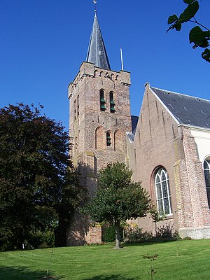
Eversdijk
Hamlet in Zeeland, Netherlands
Distance: Approx. 1951 meters
Latitude and longitude: 51.47,3.95305556
Eversdijk is a hamlet in the Dutch province of Zeeland. It is located in the municipality of Kapelle on the island of Zuid-Beveland. It was built in a typical circular style which is fairly common in south Beveland.

Kloetinge
Village in Zeeland, Netherlands
Distance: Approx. 3635 meters
Latitude and longitude: 51.49861111,3.91333333
Kloetinge is a village in the Dutch province of Zeeland. It is located in the municipality of Goes, on the eastern side of the city.

Schore, Netherlands
Village in Zeeland, Netherlands
Distance: Approx. 3796 meters
Latitude and longitude: 51.46166667,3.99944444
Schore is a village in the Dutch province of Zeeland. It is located in the municipality of Kapelle, about 8 km southwest of Goes. The village was first mentioned in 1253 as Dodinus de Scoren, and means "land on water".
Wemeldinge
Village in Zeeland, Netherlands
Distance: Approx. 4148 meters
Latitude and longitude: 51.5175,3.99555556
Wemeldinge is the oldest village in the Zuid-Beveland area of the Dutch province of Zeeland. It is located in the municipality of Kapelle, about 4 km northwest of Yerseke. It is located within the Eastern Scheldt national park.
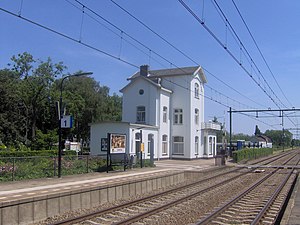
Kapelle-Biezelinge railway station
Railway station in the Netherlands
Distance: Approx. 781 meters
Latitude and longitude: 51.48027778,3.95722222
Kapelle-Biezelinge is a railway station located in Kapelle and near the housing area of Biezelinge, The Netherlands. The station was opened on 1 July 1868 and is located on the Roosendaal–Vlissingen railway. The train service is operated by Nederlandse Spoorwegen.

Biezelinge
Neighbourhood and former village in Kapelle, Zeeland, Netherlands
Distance: Approx. 482 meters
Latitude and longitude: 51.48333333,3.96666667
Biezelinge is a neighbourhood of Kapelle and former village in the Dutch municipality of Kapelle (province of Zeeland). The village is separated from Kapelle by a railroad. The two villages share a train station.

Hansweert
Village in Zeeland, Netherlands
Distance: Approx. 5068 meters
Latitude and longitude: 51.44888889,4.00305556
Hansweert is a village in the southwest Netherlands. It is located on the Zuid-Beveland peninsula, in the municipality of Reimerswaal, Zeeland.
Weather in this IP's area
overcast clouds
15 Celsius
15 Celsius
14 Celsius
16 Celsius
996 hPa
95 %
996 hPa
996 hPa
10000 meters
6.67 m/s
10.77 m/s
217 degree
100 %
07:56:38
19:06:18