Country:
 Netherlands
Region:
City:
Latitude and Longitude:
Time Zone:
Postal Code:
IP information under different IP Channel
ip-api
Country
Region
City
ASN
Time Zone
ISP
Blacklist
Proxy
Latitude
Longitude
Postal
Route
IPinfo
Country
Region
City
ASN
Time Zone
ISP
Blacklist
Proxy
Latitude
Longitude
Postal
Route
MaxMind
Country
Region
City
ASN
Time Zone
ISP
Blacklist
Proxy
Latitude
Longitude
Postal
Route
Luminati
Country
NLRegion
ge
City
barneveld
ASN
Time Zone
Europe/Amsterdam
ISP
DELTA Fiber Nederland B.V.
Latitude
Longitude
Postal
db-ip
Country
Region
City
ASN
Time Zone
ISP
Blacklist
Proxy
Latitude
Longitude
Postal
Route
ipdata
Country
Region
City
ASN
Time Zone
ISP
Blacklist
Proxy
Latitude
Longitude
Postal
Route
Popular places and events near this IP address

Barneveld (municipality)
Municipality in Gelderland, Netherlands
Distance: Approx. 1437 meters
Latitude and longitude: 52.13333333,5.58333333
Barneveld (Dutch pronunciation: [ˈbɑrnəˌvɛlt] ) is a municipality in the province of Gelderland in the center of the Netherlands. It is known for its poultry industry and large Protestant community. The municipality had a population of 59,992 in 2021, out of which 33,800 (2018) lived in the town itself.

't Woud
Hamlet in Gelderland, Netherlands
Distance: Approx. 6200 meters
Latitude and longitude: 52.1955,5.5554
't Woud is a hamlet in the Dutch province of Gelderland. It is a part of the municipality of Nijkerk, and lies about 12 km east of Amersfoort. 't Woud was founded by farmers at the beginning of the 20th century.

Voorthuizen
Village in Gelderland, Netherlands
Distance: Approx. 4692 meters
Latitude and longitude: 52.18611111,5.60666667
Voorthuizen (Dutch Low Saxon: Voorthuzen) is a village in the municipality of Barneveld, in the Dutch province of Gelderland.

Appel, Netherlands
Hamlet in Gelderland, Netherlands
Distance: Approx. 5963 meters
Latitude and longitude: 52.1875,5.54027778
Appel (literally "apple") is a hamlet in the Dutch province of Gelderland. It is located in the municipality Nijkerk, about 6 km southeast of the city, on the border with the municipality of Barneveld. It was first mentioned in 1146 as Appele.

Barneveld Centrum railway station
Railway station in the Netherlands
Distance: Approx. 601 meters
Latitude and longitude: 52.13972222,5.59
Barneveld Centrum is a railway station located in Barneveld, Netherlands. The station was opened on 1 May 1902 and is located on the Valleilijn. The station closed on 7 September 1944 and re-opened 20 May 1951.
Barneveld Noord railway station
Railway station in the Netherlands
Distance: Approx. 1852 meters
Latitude and longitude: 52.16111111,5.59833333
Barneveld Noord is a railway station located in Harselaar and the north of Barneveld, Netherlands. The distance to the railway station from the center of the city Barneveld Centrum is 2.8 kilometers. The station was opened on 15 May 1938 and is located on the Valleilijn.

Terschuur
Village in Gelderland, Netherlands
Distance: Approx. 5550 meters
Latitude and longitude: 52.1634,5.5176
Terschuur is a village in the Dutch province of Gelderland. It is located in the municipality of Barneveld.

De Hoeksteen, Barneveld
Church in Barneveld, Netherlands
Distance: Approx. 1437 meters
Latitude and longitude: 52.13333333,5.58333333
De Hoeksteen (The Cornerstone) in Barneveld, the Netherlands, is the second largest church building in the Netherlands. It is used by the congregation of the Gereformeerde Gemeenten in Nederland, a highly conservative denomination. The church services are conducted using exclusively the Statenvertaling (Dutch for States Translation) of the Bible.

Kootwijkerbroek
Village in Gelderland, Netherlands
Distance: Approx. 5065 meters
Latitude and longitude: 52.15,5.66666667
Kootwijkerbroek is a village in the Netherlands, on the Veluwe, in the municipality of Barneveld, Gelderland, Netherlands. The village, situated in the Gelderland Valley, east of Barneveld, has a major agricultural role in this part of the valley with most of the 157 companies located in Kootwijkerbroek involved in agriculture and industry. Kootwijkerbroek is an old village just between Kootwijk and Barneveld, with many generations traditionally involved in milling.
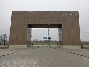
Barneveld Zuid railway station
Railway station in the Netherlands
Distance: Approx. 1815 meters
Latitude and longitude: 52.12944444,5.60194444
Barneveld Zuid (English: Barneveld South) is a railway station in the south of Barneveld, Netherlands. The station opened on 2 February 2015 and is located on the Nijkerk–Ede-Wageningen railway, also known as the Valleilijn. The train services are operated by Connexxion.
Barneveld (town)
Town in Gelderland, Netherlands
Distance: Approx. 1437 meters
Latitude and longitude: 52.13333333,5.58333333
Barneveld is a town in the Dutch province of Gelderland and also the administrative center of the eponymous municipality.

Camp Barneveld
Nazi camp for Jews in the occupied Netherlands
Distance: Approx. 1437 meters
Latitude and longitude: 52.13333333,5.58333333
Camp Barneveld was an internment camp consisting of two buildings for Dutch Jews near the town of Barneveld, the Netherlands during the German occupation in World War II. Dutch civil servant Karel Frederiks had made an arrangement, later called Plan Frederiks, with the occupiers to keep a small group of Dutch Jews in the Netherlands and exclude them from deportation to the labour, concentration, or extermination camps abroad. At first, in December 1942, a castle called De Schaffelaar was used to house the interned Jews. When De Schaffelaar was full, a nearby large villa called De Biezen and its barracks were added.
Weather in this IP's area
light rain
14 Celsius
14 Celsius
13 Celsius
15 Celsius
1013 hPa
95 %
1013 hPa
1011 hPa
10000 meters
2.35 m/s
4.15 m/s
276 degree
93 %
08:09:53
18:34:52