149.140.27.184 - IP Lookup: Free IP Address Lookup, Postal Code Lookup, IP Location Lookup, IP ASN, Public IP
Country:
Region:
City:
Location:
Time Zone:
Postal Code:
IP information under different IP Channel
ip-api
Country
Region
City
ASN
Time Zone
ISP
Blacklist
Proxy
Latitude
Longitude
Postal
Route
Luminati
Country
Region
20
ASN
Time Zone
Europe/Istanbul
ISP
Vodafone Telekomunikasyon A.S.
Latitude
Longitude
Postal
IPinfo
Country
Region
City
ASN
Time Zone
ISP
Blacklist
Proxy
Latitude
Longitude
Postal
Route
IP2Location
149.140.27.184Country
Region
denizli
City
pamukkale
Time Zone
Europe/Istanbul
ISP
Language
User-Agent
Latitude
Longitude
Postal
db-ip
Country
Region
City
ASN
Time Zone
ISP
Blacklist
Proxy
Latitude
Longitude
Postal
Route
ipdata
Country
Region
City
ASN
Time Zone
ISP
Blacklist
Proxy
Latitude
Longitude
Postal
Route
Popular places and events near this IP address

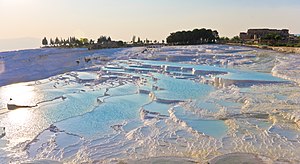
Pamukkale
Natural site in Denizli Province in southwestern Turkey
Distance: Approx. 988 meters
Latitude and longitude: 37.92388889,29.12333333
Pamukkale, (Turkish pronunciation: [pamuk̚'kalɛ]) meaning "cotton castle" in Turkish, is a natural site in Denizli Province in southwestern Turkey. The area is famous for a carbonate mineral left by the flowing of thermal spring water. It is located in Turkey's Inner Aegean region, in the River Menderes valley, which has a temperate climate for most of the year.

Laodicea on the Lycus
Ancient town in Phrygia, Asia Minor, now Turkey
Distance: Approx. 9010 meters
Latitude and longitude: 37.83583333,29.1075
Laodicea on the Lycus (Greek: Λαοδίκεια πρὸς τοῦ Λύκου Laodikeia pros tou Lykou; Latin: Laodicea ad Lycum, also transliterated as Laodiceia or Laodikeia) (modern Turkish: Laodikeia) was a rich ancient Greek city in Asia Minor, now Turkey, on the river Lycus (Çürüksu). It was located in the Hellenistic regions of Caria and Lydia, which later became the Roman Province of Phrygia Pacatiana. It is now near the modern city of Denizli.

Hierapolis
Ancient Greek city
Distance: Approx. 1216 meters
Latitude and longitude: 37.925,29.12583333
Hierapolis (; Ancient Greek: Ἱεράπολις, lit. "Holy City") was a Hellenistic Greek city built on the site of a Phrygian cult center of the Anatolian mother goddess Cybele, in Phrygia in southwestern Anatolia. It was famous for its hot springs, its high quality wool fabrics and dyes, and as the birthplace of the Stoic philosopher Epictetus.

Ploutonion at Hierapolis
Ancient shrine to god Pluto in Turkey
Distance: Approx. 1428 meters
Latitude and longitude: 37.9268,29.12681389
The Ploutonion at Hierapolis (Ancient Greek: Πλουτώνειον Ploutōneion, lit "Place of Pluto"; Latin: Plutonium) or Pluto's Gate was a ploutonion (a religious site dedicated to the god Pluto) in the ancient city of Hierapolis near Pamukkale in modern Turkey's Denizli Province. The site was discovered in 1965 by Italian archaeologists, who published reports on their excavations throughout the decade. Following the studies carried out on site in 1998, a geologist of the Italian National Research Council, Luigi Piccardi, recognized that the origin of both the Ploutonion and of the nearby Apollo's Oracle of Hierapolis was linked to the existence of the surface trace of a seismic fault, on which both sanctuaries were purposely built and which was revered as Gateway of Hades.

Pamukkale, Denizli
District and municipality in Denizli, Turkey
Distance: Approx. 63 meters
Latitude and longitude: 37.91666667,29.11666667
Pamukkale, formerly known as Akköy, is a municipality and district of Denizli Province, Turkey. Its area is 823 km2, and its population is 347,926 (2022). It first came into existence with the fusion of two small villages, Aziziye and Sultaniye in reference to the 19th century Ottoman sultan, founded by Dagestani refugees of the Russo-Turkish War (1877-1878).

Goncalı railway station
Hardik patel
Distance: Approx. 7614 meters
Latitude and longitude: 37.848002,29.116652
Goncalı railway station (Turkish: Goncalı istasyonu) is a railway station in the village of Goncali, Turkey. Located about 9 km (5.6 mi) northwest of Denizli, the station is also a junction where the Goncalı-Denizli railway splits off from the İzmir-Eğirdir railway. TCDD Taşımacılık operates a daily inter-city train from Denizli to Eskişehir, as well as regional train service to İzmir and Söke.
Siege of Laodicea (1119)
Distance: Approx. 9010 meters
Latitude and longitude: 37.83583056,29.1075
The siege of Laodicea resulted in the Byzantine capture of the Seljuq Turkish city of Laodicea in 1119.
Aşağışamlı, Merkezefendi
Village in Turkey
Distance: Approx. 7721 meters
Latitude and longitude: 37.9115,29.0296
Aşağışamlı is a neighbourhood of the municipality and district of Merkezefendi, Denizli Province, Turkey. Its population is 979 (2022). Before the 2013 reorganisation, it was a town (belde).
Çeltikçi, Merkezefendi
Village in Turkey
Distance: Approx. 5540 meters
Latitude and longitude: 37.8712,29.0909
Çeltikçi is a neighbourhood in the municipality and district of Merkezefendi, Denizli Province in Turkey. Its population is 177 (2022).
Weather in this IP's area
overcast clouds
13 Celsius
12 Celsius
13 Celsius
13 Celsius
1019 hPa
78 %
1019 hPa
937 hPa
10000 meters
1.6 m/s
2.33 m/s
150 degree
90 %