149.140.109.207 - IP Lookup: Free IP Address Lookup, Postal Code Lookup, IP Location Lookup, IP ASN, Public IP
Country:
Region:
City:
Location:
Time Zone:
Postal Code:
IP information under different IP Channel
ip-api
Country
Region
City
ASN
Time Zone
ISP
Blacklist
Proxy
Latitude
Longitude
Postal
Route
Luminati
Country
Region
34
City
istanbul
ASN
Time Zone
Europe/Istanbul
ISP
Vodafone Telekomunikasyon A.S.
Latitude
Longitude
Postal
IPinfo
Country
Region
City
ASN
Time Zone
ISP
Blacklist
Proxy
Latitude
Longitude
Postal
Route
IP2Location
149.140.109.207Country
Region
canakkale
City
lapseki
Time Zone
Europe/Istanbul
ISP
Language
User-Agent
Latitude
Longitude
Postal
db-ip
Country
Region
City
ASN
Time Zone
ISP
Blacklist
Proxy
Latitude
Longitude
Postal
Route
ipdata
Country
Region
City
ASN
Time Zone
ISP
Blacklist
Proxy
Latitude
Longitude
Postal
Route
Popular places and events near this IP address
Aegospotami
River in Turkey
Distance: Approx. 7389 meters
Latitude and longitude: 40.332,26.6
Aegospotami (Ancient Greek: Αἰγὸς Ποταμοί, Aigos Potamoi) or Aegospotamos (i.e. Goat Streams) is the ancient Greek name for a small river or rivers issuing into the Hellespont (Modern Turkish Çanakkale Boğazı), northeast of Sestos. Aegospotami is plural, which suggests that the name may have referred to multiple rivers.

Lampsacus
Ancient Greek city located on the eastern side of the Hellespont in the northern Troad
Distance: Approx. 1183 meters
Latitude and longitude: 40.34666667,26.69916667
Lampsacus (; Ancient Greek: Λάμψακος, romanized: Lampsakos) was an ancient Greek city strategically located on the eastern side of the Hellespont in the northern Troad. An inhabitant of Lampsacus was called a Lampsacene. The name has been transmitted in the nearby modern town of Lapseki.

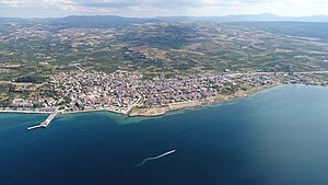
Lapseki
Municipality in Çanakkale, Turkey
Distance: Approx. 172 meters
Latitude and longitude: 40.34388889,26.68361111
Lapseki (from Greek: Λάμψακος, Lampsakos) is a town in Çanakkale Province, Turkey. It is the seat of Lapseki District. Its population is 14,984 (2021).

Fall of Gallipoli
14th century battle between the Byzantine Empire and the Ottoman Empire
Distance: Approx. 7790 meters
Latitude and longitude: 40.4133,26.6711
The fall of Gallipoli (Turkish: Gelibolu'nun Fethi, lit. 'Conquest of Gelibolu') was the siege and capture of the Gallipoli fortress and peninsula, by the Ottoman Turks, in March 1354. After suffering a half-century of defeats at the hands of the Ottomans, the Byzantine Empire had lost nearly all of its possessions in Anatolia, except Philadelphia. Access to the Aegean and Marmara seas meant that the Ottomans could now implement the conquest of the southern Balkans, and could advance further north into the Serbian Empire and Hungary.
Cressa (Thrace)
Ancient Greek city located in ancient Thrace
Distance: Approx. 5127 meters
Latitude and longitude: 40.351152,26.625855
Cressa or Kressa (Ancient Greek: Κρῆσσα) was an ancient Greek city located in ancient Thrace, on the Thracian Chersonesus. It is cited in the Periplus of Pseudo-Scylax, in the second position of its recitation of the towns of the Thracian Chersonesus, along with Aegospotami, Cressa, Crithote and Pactya. It may be the same town cited by Pliny the Elder as Crissa on the Propontis.
Crithote (Thrace)
Ancient Greek city located in Thrace
Distance: Approx. 7532 meters
Latitude and longitude: 40.406725,26.651664
Crithote or Krithote (Ancient Greek: Κριθωτή or Κριθώτη) was an ancient Greek city located in Thrace, located in the region of the Thracian Chersonesos. It was on the Hellespont north of Gallipolis, and was an Athenian colony founded by Miltiades. It is cited in the Periplus of Pseudo-Scylax among the cities of the Thracian Chersonesos: Aegospotami, Cressa, Crithote, and Pactya.

Çardak, Çanakkale
Municipality in Çanakkale, Turkey
Distance: Approx. 5091 meters
Latitude and longitude: 40.38333333,26.71666667
Çardak is a town (belde) in the Lapseki District, Çanakkale Province, Turkey. Its population is 3,705 (2021).

1915 Çanakkale Bridge
Suspension bridge across the Dardanelles in Turkey
Distance: Approx. 4225 meters
Latitude and longitude: 40.34,26.63611111
The 1915 Çanakkale Bridge (Turkish: 1915 Çanakkale Köprüsü) is a road suspension bridge in the province of Çanakkale in northwestern Turkey. Situated just south of the coastal towns of Lapseki and Gelibolu, the bridge spans the Dardanelles, about 10 km (6.2 mi) south of the Sea of Marmara. The bridge is the longest suspension bridge in the world—with a main span of 2,023 m (2.023 km; 1.257 mi), the bridge surpasses the Akashi Kaikyo Bridge (1998) in Japan by 32 m (105 ft).

Gelibolu War Museum
War Museum
Distance: Approx. 7111 meters
Latitude and longitude: 40.40666667,26.66805556
Gelibolu War Museum (Turkish: Gelibolu Savaş Müzesi) is a museum in Gelibolu, Turkey.
Abarnis
Ancient Greek town on coast of Asia Minor
Distance: Approx. 5610 meters
Latitude and longitude: 40.378253,26.734359
Abarnis (Ancient Greek: Ἀβαρνίς), also known as Abarnias, Abarnos (Ἄβαρνος), and Aparnis (Ancient Greek: Ἀπαρνίς) was a coastal town in ancient Mysia, on a promontory of the same name. Xenophon speaks of the place as where Conon, during his engagements with Lysander, stole the sails of the Spartan fleet, reorganized his fleet and fled to refuge with Evagoras I, while dispatching the Paralus to Athens to bring news from the battles. Its site is tentatively located near Çardak, Asiatic Turkey.

Kocaveli, Lapseki
Village in Turkey
Distance: Approx. 4924 meters
Latitude and longitude: 40.3,26.68333333
Kocaveli is a village in the Lapseki District of Çanakkale Province in Turkey. Its population is 104 (2021).

Lapseki District
District of Çanakkale Province, Turkey
Distance: Approx. 4043 meters
Latitude and longitude: 40.31666667,26.71666667
Lapseki District is a district of the Çanakkale Province of Turkey. Its seat is the town of Lapseki. Its area is 821 km2, and its population is 28,742 (2021).
Weather in this IP's area
overcast clouds
8 Celsius
4 Celsius
8 Celsius
8 Celsius
1015 hPa
92 %
1015 hPa
1012 hPa
10000 meters
8.58 m/s
13.56 m/s
21 degree
100 %