149.13.113.69 - IP Lookup: Free IP Address Lookup, Postal Code Lookup, IP Location Lookup, IP ASN, Public IP
Country:
Region:
City:
Location:
Time Zone:
Postal Code:
IP information under different IP Channel
ip-api
Country
Region
City
ASN
Time Zone
ISP
Blacklist
Proxy
Latitude
Longitude
Postal
Route
Luminati
Country
Region
idf
City
lagarennecolombes
ASN
Time Zone
Europe/Paris
ISP
Streamwide SA
Latitude
Longitude
Postal
IPinfo
Country
Region
City
ASN
Time Zone
ISP
Blacklist
Proxy
Latitude
Longitude
Postal
Route
IP2Location
149.13.113.69Country
Region
ile-de-france
City
la garenne-colombes
Time Zone
Europe/Paris
ISP
Language
User-Agent
Latitude
Longitude
Postal
db-ip
Country
Region
City
ASN
Time Zone
ISP
Blacklist
Proxy
Latitude
Longitude
Postal
Route
ipdata
Country
Region
City
ASN
Time Zone
ISP
Blacklist
Proxy
Latitude
Longitude
Postal
Route
Popular places and events near this IP address
La Garenne-Colombes
Commune in Île-de-France, France
Distance: Approx. 202 meters
Latitude and longitude: 48.9056,2.2445
La Garenne-Colombes (French pronunciation: [la gaʁɛn kɔlɔ̃b] ) is a commune in the northwestern suburbs of Paris, France. It is located 9.6 km (6.0 mi) from Notre Dame de Paris, France's kilometre zero.

Courbevoie
Commune in Île-de-France, France
Distance: Approx. 892 meters
Latitude and longitude: 48.8978,2.2531
Courbevoie (French pronunciation: [kuʁbəvwa] ) is a commune located in the Hauts-de-Seine department of the Île-de-France region of France. It is a suburb of Paris, 8.2 km (5.1 mi) from the center of Paris. The centre of Courbevoie is situated 2 km (1.2 mi) from the city limits of Paris.

Tour Égée
Office skyscraper located in La Défense
Distance: Approx. 1099 meters
Latitude and longitude: 48.89652778,2.23847222
Tour Égée (also known as tour Ernst&Young) is an office skyscraper located in La Défense, the high-rise business district situated west of Paris, France. Tour Égée was built in 1999 by Michel Andrault and Nicolas Ayoub, architects from Conceptua. A twin of Tour Égée, Tour Adria, was built nearby three years later in 2002.

Tour T1
Office skyscraper in La Défense, the high-rise business district west of Paris, France
Distance: Approx. 1101 meters
Latitude and longitude: 48.89611111,2.23944444
Tour T1 (also known as the Tour GDF Suez) is an office skyscraper in La Défense, the high-rise business district west of Paris, France. Construction began in 2005 and the tower was completed and opened in 2008. The tower, 185 m (607 ft) tall, is the third-tallest skyscraper in La Défense after the Tour Total (190m) and Tour First (231m).

Courbevoie station
Railway station in Hauts-de-Seine department, France
Distance: Approx. 720 meters
Latitude and longitude: 48.89833333,2.24861111
Courbevoie is a railway station serving the town Courbevoie, Hauts-de-Seine department, in the western suburbs of Paris, France. It is served by Transilien Line L services between Paris Gare Saint-Lazare and Gare de Saint-Cloud.

Lycée Paul Lapie
Senior high school in France
Distance: Approx. 838 meters
Latitude and longitude: 48.9005,2.2564
Lycée Paul Lapie is a French senior high school/sixth-form college in Courbevoie, Hauts-de-Seine, France, in the Paris metropolitan area. The school building, designed by Florent Nanquette, opened in the fall of 1933. The school's design plans had been made in 1930.

Canton of Colombes-2
Administrative division of Hauts-de-Seine, France
Distance: Approx. 777 meters
Latitude and longitude: 48.91,2.24
The canton of Colombes-2 is an administrative division of the Hauts-de-Seine department, in northern France. It was created at the French canton reorganisation which came into effect in March 2015. Its seat is in Colombes.
Canton of Courbevoie-1
Administrative division of Hauts-de-Seine, France
Distance: Approx. 1092 meters
Latitude and longitude: 48.9,2.26
The canton of Courbevoie-1 is an administrative division of the Hauts-de-Seine department, in northern France. It was created at the French canton reorganisation which came into effect in March 2015. Its seat is in Courbevoie.
Canton of Courbevoie-2
Administrative division of Hauts-de-Seine, France
Distance: Approx. 727 meters
Latitude and longitude: 48.9,2.24
The canton of Courbevoie-2 is an administrative division of the Hauts-de-Seine department, in northern France. It was created at the French canton reorganisation which came into effect in March 2015. Its seat is in Courbevoie.

European School of Paris-La Défense
School in Courbevoie, France
Distance: Approx. 1033 meters
Latitude and longitude: 48.896,2.242
The European School of Paris-La Défense (French: École Européenne Paris-La Défense) is a public Accredited European School in the business district of La Défense near Paris, France. Founded in 2019, it is an all-through school, which offers a multicultural and multilingual education leading to the European Baccalaureate as its secondary leaving qualification.
Centre Charras
Distance: Approx. 1135 meters
Latitude and longitude: 48.89525,2.25272222
Complexe Urbain Charras, promoted in real estate as Zodiaque and commonly called Centre Charras, is a former military garrison site and current residential and entertainment district in Courbevoie, Hauts-de-Seine, France.

La Garenne-Colombes station
Railway station in La Garenne-Colombes, France
Distance: Approx. 734 meters
Latitude and longitude: 48.90943407,2.2399216
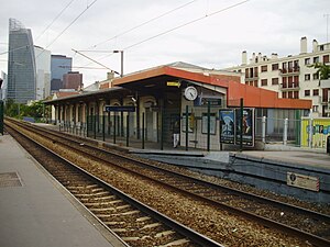
La Garenne-Colombes station is a French railway station serving the commune of La Garenne-Colombes on the Paris–Saint-Germain-en-Laye railway. It is largely located on the territory of the commune of Colombes, on the edge of the commune of La Garenne-Colombes, from where the main entrance to the station is located on Rue de l'Arrivée. This station is served by trains from the Line L of the Transilien commuter rail network.
Weather in this IP's area
light rain
7 Celsius
3 Celsius
7 Celsius
7 Celsius
1022 hPa
88 %
1022 hPa
1011 hPa
10000 meters
5.66 m/s
200 degree
75 %
