Country:
 USA
USARegion:
City:
Latitude and Longitude:
Time Zone:
Postal Code:
IP information under different IP Channel
ip-api
Country
Region
City
ASN
Time Zone
ISP
Blacklist
Proxy
Latitude
Longitude
Postal
Route
IPinfo
Country
Region
City
ASN
Time Zone
ISP
Blacklist
Proxy
Latitude
Longitude
Postal
Route
MaxMind
Country
Region
City
ASN
Time Zone
ISP
Blacklist
Proxy
Latitude
Longitude
Postal
Route
Luminati
Country
USASN
Time Zone
America/Chicago
ISP
LEVEL3
Latitude
Longitude
Postal
db-ip
Country
Region
City
ASN
Time Zone
ISP
Blacklist
Proxy
Latitude
Longitude
Postal
Route
ipdata
Country
Region
City
ASN
Time Zone
ISP
Blacklist
Proxy
Latitude
Longitude
Postal
Route
Popular places and events near this IP address

Onizuka Air Force Station
Military space communications and satellite testing site in Sunnyvale, California
Distance: Approx. 816 meters
Latitude and longitude: 37.40486111,-122.02875
Onizuka Air Force Station or Onizuka AFS was a United States Air Force installation in Sunnyvale, California, at the intersection of State Route 237 and North Mathilda Avenue. It operated from 1960 to 2010. One of its distinguishing feature was Building 1003, known locally as the Blue Cube and the "Cube" given its shape, color, and lack of windows.

Middlefield station
VTA light rail station in Mountain View, California
Distance: Approx. 1810 meters
Latitude and longitude: 37.395639,-122.05225
Middlefield station is a light rail station operated by Santa Clara Valley Transportation Authority (VTA), located in Mountain View, California. This station is served by the Orange Line of the VTA light rail system. Middlefield station is surrounded by an industrial area which includes some transit-oriented development on Middlefield Road between Ellis Street and Logue Avenue.

Bayshore/NASA station
VTA light rail station in Mountain View, California
Distance: Approx. 1740 meters
Latitude and longitude: 37.404611,-122.049833
Bayshore/NASA station is a light rail station operated by Santa Clara Valley Transportation Authority (VTA), located in Mountain View, California. This station is served by the Orange Line of the VTA light rail system.

Moffett Park station
VTA light rail station in Sunnyvale, California
Distance: Approx. 509 meters
Latitude and longitude: 37.402444,-122.033333
Moffett Park station is a light rail station operated by Santa Clara Valley Transportation Authority (VTA), located in Sunnyvale, California. Moffett Park was built as an infill station. This station is served by the Orange Line of the VTA light rail system.
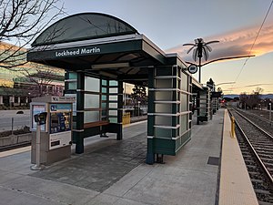
Lockheed Martin Transit Center
VTA light rail station in Sunnyvale, California
Distance: Approx. 1353 meters
Latitude and longitude: 37.409556,-122.02725
Lockheed Martin Transit Center (signed as simply Lockheed Martin station on many signs) is a light rail and transit bus station operated by Santa Clara Valley Transportation Authority (VTA), located in Sunnyvale, California. This station is served by the Orange Line of the VTA light rail system. The land for the transit center was donated by Lockheed Martin during the planning of VTA's Tasman West light rail extension.

Borregas station
VTA light rail station in Sunnyvale, California
Distance: Approx. 1958 meters
Latitude and longitude: 37.41166667,-122.01805556
Borregas station is a light rail station operated by Santa Clara Valley Transportation Authority (VTA), located in Sunnyvale, California. This station is served by the Orange Line of the VTA light rail system. The station is located in an industrial area; nearby offices include the headquarters of Infinera and Ruckus Networks.

Fair Oaks station
VTA light rail station in Sunnyvale, California
Distance: Approx. 2088 meters
Latitude and longitude: 37.40277778,-122.00916667
Fair Oaks station is a light rail station operated by Santa Clara Valley Transportation Authority (VTA), located in Sunnyvale, California. This station is served by the Orange Line of the VTA light rail system.
Hacker Dojo
Community center and hackerspace in Santa Clara, California, United States
Distance: Approx. 1517 meters
Latitude and longitude: 37.3963152,-122.04902
Hacker Dojo is a 6,000-square-foot (560 m2) community center and hackerspace that is based in Mountain View, California. Predominantly an open working space for software projects, the Dojo hosts technology classes for biology, computer hardware, and manufacturing events. The Dojo is run mostly democratically by its membership.

John W. Christian Greenbelt
Distance: Approx. 891 meters
Latitude and longitude: 37.399,-122.022
The John W. Christian Greenbelt is a stretch of green land in northern Sunnyvale, California.
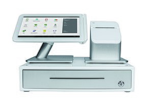
Clover Network
Cloud-based Android point of sale platform
Distance: Approx. 1269 meters
Latitude and longitude: 37.3866,-122.03168611
Clover is a cloud-based Android point of sale (POS) platform that was launched in April 2012. The company is headquartered in Sunnyvale, California, United States. As of the quarter ended September 2020, Clover processed $133 billion of annualized card transactions worldwide, making it the largest U.S. cloud POS firm.

Martin Murphy House
Historic site in Santa Clara County, California, United States
Distance: Approx. 1839 meters
Latitude and longitude: 37.38222222,-122.02583333
The Martin Murphy House was a historic home located in Santa Clara County, California. It was the residence of Martin Murphy Jr., who journeyed to California with his family in 1844, as part of the first wagon train to cross the Sierra Nevada. As the founder of Sunnyvale, Murphy constructed a prefabricated lumber house in the area, which had been transported around Cape Horn in 1849.

Pellier Park
Template for California Historical Landmarks in Santa Clara County.
Distance: Approx. 1839 meters
Latitude and longitude: 37.38222222,-122.02583333
Pellier Park, is a city park covering 0.5 acres (0.20 ha) in San Jose, California, United States, located in close proximity to San Pedro Square. This park holds historical significance as it was once home to City Gardens, a nursery founded by Louis Pellier (1817–1872), who is known as the pioneer of California's prune industry. In October 1850, Pellier established the City Gardens, where with the assistance of his brothers Pierre and Jean, he introduced the French prune, also known as "la petite prune d'Agen," which translates to "the little Agen plum," to California during the winter of 1856.
Weather in this IP's area
overcast clouds
20 Celsius
20 Celsius
17 Celsius
21 Celsius
1011 hPa
60 %
1011 hPa
1010 hPa
10000 meters
2.57 m/s
340 degree
100 %
06:51:30
19:14:13