Country:
 Canada
Region:
City:
Latitude and Longitude:
Time Zone:
Postal Code:
IP information under different IP Channel
ip-api
Country
Region
City
ASN
Time Zone
ISP
Blacklist
Proxy
Latitude
Longitude
Postal
Route
IPinfo
Country
Region
City
ASN
Time Zone
ISP
Blacklist
Proxy
Latitude
Longitude
Postal
Route
MaxMind
Country
Region
City
ASN
Time Zone
ISP
Blacklist
Proxy
Latitude
Longitude
Postal
Route
Luminati
Country
CARegion
on
City
collingwood
ASN
Time Zone
America/Toronto
ISP
OXIO-ASN-01
Latitude
Longitude
Postal
db-ip
Country
Region
City
ASN
Time Zone
ISP
Blacklist
Proxy
Latitude
Longitude
Postal
Route
ipdata
Country
Region
City
ASN
Time Zone
ISP
Blacklist
Proxy
Latitude
Longitude
Postal
Route
Popular places and events near this IP address

Collingwood, Ontario
Town in Ontario, Canada
Distance: Approx. 2238 meters
Latitude and longitude: 44.5,-80.21666667
Collingwood is a town in Simcoe County, Ontario, Canada. It is situated on Nottawasaga Bay at the southern point of Georgian Bay. Collingwood is well known as a tourist destination, for its skiing in the winter, and limestone caves along the Niagara Escarpment in the summer.
CFRH-FM
Francophone community radio station in Penetanguishene, Ontario
Distance: Approx. 8728 meters
Latitude and longitude: 44.47833333,-80.32666667
CFRH-FM is a Canadian radio station, broadcasting at 88.1 FM in Penetanguishene, Ontario. Owned and operated by the Radio-Huronie cooperative, it is a non-profit French-language community radio station for the region's Franco-Ontarian community.
Collingwood Airport
Airport in Collingwood, Ontario
Distance: Approx. 5697 meters
Latitude and longitude: 44.44944444,-80.15916667
Collingwood Airport (TC LID: CNY3) is a medium-sized registered aerodrome located 4 nautical miles (7.4 km; 4.6 mi) southeast of Collingwood, Ontario, Canada, 45 km (28 mi) west of Barrie and 150 km (93 mi) north of Toronto. It is located in the township of Clearview, near Wasaga Beach and the ski hills of Blue Mountain. The aerodrome is listed by Nav Canada as being an airport of entry and the Canada Border Services Agency agents can handle general aviation aircraft with up to 15 occupants.
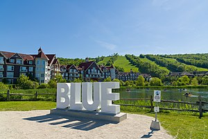
Blue Mountain (ski resort)
Alpine ski resort in Ontario, Canada
Distance: Approx. 7973 meters
Latitude and longitude: 44.50277778,-80.31194444
Blue Mountain is an alpine ski resort in Ontario, Canada, 10 km west of Collingwood. It is situated on a section of the Niagara Escarpment about 1 km (0.6 mi.) from Nottawasaga Bay, and is a major destination for skiers from southern Ontario. The local area forms the newly incorporated town of The Blue Mountains, Ontario.
CKCB-FM
Radio station in Collingwood, Ontario
Distance: Approx. 8728 meters
Latitude and longitude: 44.47833333,-80.32666667
CKCB-FM is a Canadian radio station broadcasting at 95.1 MHz in Collingwood, Ontario, with an adult contemporary format branded on-air as 95.1 The Peak FM. The station began broadcasting in 1965 on 1400 kHz, until it moved to its current frequency in 1994. The station went through different ownerships over the years and in 2000 was acquired by Corus Entertainment. The original on-air personality, who signed on CKCB at a community reception held at the Collingwood Shriner's Hall on the evening of Tuesday October 12, 1965 was Jim Craig, who went on to enjoy a successful Radio and TV career in SW Ontario and Western Canada prior to moving into teaching.
CFMO-FM
Radio station in Collingwood, Ontario
Distance: Approx. 8817 meters
Latitude and longitude: 44.47805556,-80.32777778
CFMO-FM (Classical 102.9) is a radio station broadcasting a classical music format on 102.9 MHz FM in Collingwood, Ontario, Canada. The station is owned by ZoomerMedia, through licensee MZ Media Inc. It is largely a semi-satellite of ZoomerMedia's CFMZ-FM 96.3 in Toronto.
Nottawasaga Pines Secondary School
School in Essa, Ontario, Canada
Distance: Approx. 817 meters
Latitude and longitude: 44.4872,-80.2157
Nottawasaga Pines Secondary School, also known as NPSS, is a public secondary school in Angus, Ontario. The principal is Colleen Ireland. It opened in September 2011, and currently has curriculum for Grades 9–12.
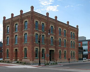
Collingwood Shipbuilding
Distance: Approx. 2709 meters
Latitude and longitude: 44.50422222,-80.21797222
Collingwood Shipbuilding was a major Canadian shipbuilder of the late 19th and 20th centuries. The facility was located in the Great Lakes and saw its business peak during the Second World War. The shipyard primarily constructed lake freighters for service on the Great Lakes but also constructed warships during the Second World War and government ships postwar.
Collingwood Collegiate Institute
School in Collingwood, Ontario, Canada
Distance: Approx. 817 meters
Latitude and longitude: 44.4872,-80.2157
Collingwood Collegiate Institute (known as CCI) is a public secondary school (grades 9–12) located in Collingwood, Ontario, Canada. It currently has an enrollment of about 1399 students and employs over 80 teachers and staff. The principal is Kelly Lalonde.

Craigleith Heritage Depot
Former railroad station-turned-community hub
Distance: Approx. 9975 meters
Latitude and longitude: 44.52513,-80.32526
The Craigleith Heritage Depot is a museum, library, tourism and community hub serving The Blue Mountains, Ontario in partnership with The Town of The Blue Mountains Public Library and is the last remaining station standing on Canada's first long-line railroad. It is located on the corner of Highway 26 and Grey Road 19 on the south side of Georgian Bay. Erected in the 1880s, the Craigleith Heritage Depot was originally a train station called Craigleith Station, then a restaurant called The Depot, currently it is a museum and an adjoined public library.
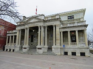
Tremont House (Collingwood, Ontario)
Distance: Approx. 2399 meters
Latitude and longitude: 44.501374,-80.21425
Tremont House, also known as the Tremont Hotel, is a historic building in the Creative Simcoe Street neighbourhood of the Collingwood Heritage Conservation District. It is located at 80 Simcoe Street in Collingwood, Ontario, Canada.
Collingwood downtown heritage conservation district
Historic district in Ontario, Canada
Distance: Approx. 2238 meters
Latitude and longitude: 44.5,-80.21666667
The town of Collingwood, Ontario, was the first municipality in Canada to have a heritage conservation district included on the Canadian Register of Historic Places.
Weather in this IP's area
clear sky
17 Celsius
17 Celsius
16 Celsius
19 Celsius
1017 hPa
85 %
1017 hPa
994 hPa
10000 meters
3.62 m/s
4.93 m/s
167 degree
07:03:53
19:25:55