Country:
 Canada
Region:
City:
Latitude and Longitude:
Time Zone:
Postal Code:
IP information under different IP Channel
ip-api
Country
Region
City
ASN
Time Zone
ISP
Blacklist
Proxy
Latitude
Longitude
Postal
Route
IPinfo
Country
Region
City
ASN
Time Zone
ISP
Blacklist
Proxy
Latitude
Longitude
Postal
Route
MaxMind
Country
Region
City
ASN
Time Zone
ISP
Blacklist
Proxy
Latitude
Longitude
Postal
Route
Luminati
Country
CARegion
on
City
hamilton
ASN
Time Zone
America/Toronto
ISP
OXIO-ASN-01
Latitude
Longitude
Postal
db-ip
Country
Region
City
ASN
Time Zone
ISP
Blacklist
Proxy
Latitude
Longitude
Postal
Route
ipdata
Country
Region
City
ASN
Time Zone
ISP
Blacklist
Proxy
Latitude
Longitude
Postal
Route
Popular places and events near this IP address

Ivor Wynne Stadium
Demolished Canadian football stadium in Hamilton, Ontario
Distance: Approx. 1043 meters
Latitude and longitude: 43.25257222,-79.83024722
Ivor Wynne Stadium (formerly Civic Stadium) was a Canadian football stadium located at the corner of Balsam and Beechwood avenues, two blocks west of Gage Avenue North in Hamilton, Ontario, Canada. The stadium was the home of the Hamilton Tiger-Cats of the CFL from 1950 until it closed on October 27, 2012. The club's previous home was the Hamilton Amateur Athletic Association Grounds.
St. Peter's Hospital (Hamilton)
Hospital in Ontario, Canada
Distance: Approx. 1304 meters
Latitude and longitude: 43.24444444,-79.84638889
St. Peter's Hospital is a 250-bed chronic care hospital located in East Hamilton, Ontario specializing in the care of older adults. The hospital became a part of Hamilton Health Sciences in 2008.
Brian Timmis Stadium
Distance: Approx. 912 meters
Latitude and longitude: 43.25138889,-79.83027778
Brian Timmis Stadium was a soccer stadium in Hamilton, Ontario. The stadium was built in 1968, and seated 5,000 people. The stadium most recently hosted association football (soccer) teams Hamilton Croatia, a Canadian Soccer League club, and the Hamilton Avalanche, a club that played in the W-League of the United Soccer Leagues.

The Centre on Barton
Shopping mall in Hamilton, Ontario
Distance: Approx. 1922 meters
Latitude and longitude: 43.252,-79.81
The Centre on Barton is an outdoor shopping centre in the Lower City of Hamilton, Ontario, Canada. The centre is located on Barton Street East bounded by Ottawa Street North in the western-end and Kenilworth Avenue North on the eastern-end. It was formerly known as the Centre Mall and before that, the Greater Hamilton Shopping Centre.
Cathedral High School (Hamilton, Ontario)
Canadian Catholic secondary school
Distance: Approx. 1863 meters
Latitude and longitude: 43.2536,-79.8484
Cathedral High School is a Catholic secondary school located in Hamilton. It is a part of the Hamilton-Wentworth Catholic District School Board and is affiliated with the nearby cathedral Christ the King.

Tim Hortons Field
Multi-purpose stadium in Hamilton, Canada
Distance: Approx. 993 meters
Latitude and longitude: 43.25211444,-79.83009972
Tim Hortons Field (French: Terrain Tim Hortons), nicknamed "The Donut Box"; is a multi-purpose stadium in Hamilton, Ontario, Canada. Completed in 2014 with a capacity of 22,500, it was built as a replacement for the Ivor Wynne Stadium at the same location since 1930. Tim Hortons Field is primarily used for Canadian football and soccer (association football), and is the home of the Hamilton Tiger-Cats of the Canadian Football League and Forge FC of the Canadian Premier League, amongst other teams.
Parkview Secondary School
Discontinued secondary school
Distance: Approx. 943 meters
Latitude and longitude: 43.2515,-79.8281
Parkview Secondary School was located at 60 Balsam Avenue Hamilton, Ontario, and was a member of the Hamilton-Wentworth District School Board. Parkview Secondary School had a 2009–2010 enrollment of 333. The school's mission statement was "Educating students to become lifelong learners and contributing citizens in a challenging, changing, multi-cultural world".

Sherwood Secondary School
School in Canada
Distance: Approx. 1828 meters
Latitude and longitude: 43.22764,-79.8232
Sherwood Secondary School is a secondary school in Hamilton, Ontario. It is operated by the Hamilton-Wentworth District School Board. The school opened in 1967.
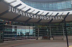
Juravinski Hospital
Hospital in Ontario, Canada
Distance: Approx. 1224 meters
Latitude and longitude: 43.23972222,-79.84472222
The Juravinski Hospital is a hospital in Hamilton, Ontario, Canada operated by Hamilton Health Sciences. It is located adjacent to the Juravinski Cancer Centre. The hospital was ranked 2nd in Canada for research according to Research Infosource Inc.
Juravinski Cancer Centre
Hospital in Ontario, Canada
Distance: Approx. 1337 meters
Latitude and longitude: 43.24027778,-79.84638889
The Juravinski Cancer Centre (JCC) is a comprehensive centre for cancer care and cancer research in Hamilton, Ontario, Canada. Operated by Hamilton Health Sciences, it is adjacent to the Juravinski Hospital, which provides emergency department facilities. The hospital was recently ranked 2nd in Canada for research according to Research Infosource Inc.
Cotton Factory
Historic industrial complex in Hamilton, Canada
Distance: Approx. 1899 meters
Latitude and longitude: 43.26011111,-79.83344444
Cotton Factory is an historic industrial complex formerly known as The Imperial Cotton Company Limited in the industrial north end of Hamilton, Canada. The complex has been renamed the Cotton Factory and is repurposed for small manufacturing and office space for creative professionals. The five buildings on the site were built in 1900 and stand today in their original structures.

Gage Park, Hamilton
Park in Hamilton, Ontario
Distance: Approx. 177 meters
Latitude and longitude: 43.2422,-79.8287
Gage Park is a large community park and civic gardens located in Hamilton, Ontario, Canada. It is located at the intersection of Main Street and Gage Avenue in East Hamilton. Gage Park is the usual site of gay pride in this part of the city.
Weather in this IP's area
mist
20 Celsius
20 Celsius
18 Celsius
21 Celsius
1017 hPa
94 %
1017 hPa
1006 hPa
8047 meters
3.09 m/s
360 degree
40 %
07:02:42
19:24:00