Country:
 Canada
Region:
City:
Latitude and Longitude:
Time Zone:
Postal Code:
IP information under different IP Channel
ip-api
Country
Region
City
ASN
Time Zone
ISP
Blacklist
Proxy
Latitude
Longitude
Postal
Route
IPinfo
Country
Region
City
ASN
Time Zone
ISP
Blacklist
Proxy
Latitude
Longitude
Postal
Route
MaxMind
Country
Region
City
ASN
Time Zone
ISP
Blacklist
Proxy
Latitude
Longitude
Postal
Route
Luminati
Country
CARegion
on
City
kitchener
ASN
Time Zone
America/Toronto
ISP
OXIO-ASN-01
Latitude
Longitude
Postal
db-ip
Country
Region
City
ASN
Time Zone
ISP
Blacklist
Proxy
Latitude
Longitude
Postal
Route
ipdata
Country
Region
City
ASN
Time Zone
ISP
Blacklist
Proxy
Latitude
Longitude
Postal
Route
Popular places and events near this IP address

Cameron Heights Collegiate Institute
High school in Kitchener, Ontario, Canada
Distance: Approx. 1970 meters
Latitude and longitude: 43.44458056,-80.48168889
Cameron Heights Collegiate Institute is a public secondary school in Kitchener, Ontario, run by the Waterloo Region District School Board. It is part of the International Baccalaureate (IB) program. The school is located at 301 Charles St.
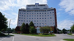
St. Mary's General Hospital
Hospital in Ontario, Canada
Distance: Approx. 618 meters
Latitude and longitude: 43.437807,-80.50174
St. Mary's General Hospital is a 197-bed adult acute-care facility in Kitchener, Ontario, Canada serving Waterloo Region and surrounding area. St.

Forest Heights Collegiate Institute
Secondary school in Kitchener, Ontario, Canada
Distance: Approx. 1914 meters
Latitude and longitude: 43.42568889,-80.52123889
Forest Heights Collegiate Institute (FHCI), shortened as Forest Heights or simply Forest, is a high school in Kitchener, Ontario, Canada that was established in 1964. It is run by the Waterloo Region District School Board (WRDSB). As of the 2019–2020 school year, Forest Heights has 1,110 students.

Schneider Haus
House in Kitchener, Canada
Distance: Approx. 1404 meters
Latitude and longitude: 43.4446,-80.4946
The Schneider Haus National Historic Site, formerly Joseph Schneider Haus, is a museum in Kitchener, Ontario, Canada. Situated on some of the earliest land to be settled by non-Indigenous peoples in what would become Waterloo County, the museum includes the oldest remaining dwelling in the area and was named a National Historic Site of Canada in 1999.

Charles Street Transit Terminal
Bus terminal in Kitchener, Ontario
Distance: Approx. 1976 meters
Latitude and longitude: 43.44944444,-80.49222222
The Charles Street Transit Terminal is a former bus terminal in Kitchener, Ontario, Canada. It is the former downtown hub for local Grand River Transit (GRT) bus services for Kitchener and Waterloo, although the terminal now sits vacant and mostly abandoned. It was the largest public service facility run by GRT, with the Cambridge Ainslie Street terminal being the only other staffed bus station, as well as once serving a number of commuter and intercity bus routes with GO Transit, and Coach Canada.

Victoria Park, Kitchener
Urban park in Kitchener, Ontario, Canada
Distance: Approx. 1619 meters
Latitude and longitude: 43.447,-80.498
Victoria Park is the oldest park in Kitchener, Ontario, Canada, situated downtown. It is the site of numerous events and festivities.

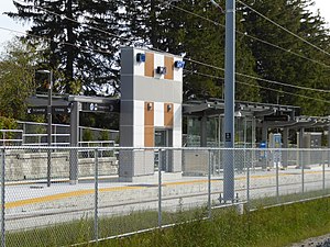
Kitchener Market station
Light rail station in Kitchener, Ontario
Distance: Approx. 2010 meters
Latitude and longitude: 43.44638889,-80.48361111
Kitchener Market is a stop on the Ion rapid transit system in the Region of Waterloo in Ontario, Canada. It is located in the Cedar Hill neighbourhood at the intersection of Charles and Cedar streets, about 100 metres (330 ft) south of its namesake, the Kitchener Farmer's Market. The station initially had a working name of Cedar, and it opened in 2019.

Frederick station (Kitchener)
Light rail station in Kitchener, Ontario
Distance: Approx. 2115 meters
Latitude and longitude: 43.44938,-80.48748
Frederick is a stop on the Region of Waterloo's Ion rapid transit system. It is located in the median of Frederick Street, just east of King Street, in downtown Kitchener. It opened in 2019.

Victoria Park station (Kitchener)
Light rail station in Kitchener, Ontario
Distance: Approx. 2024 meters
Latitude and longitude: 43.45016,-80.49354
Victoria Park is a stop on the Region of Waterloo's Ion rapid transit system. It is located alongside Charles Street, just west of Gaukel Street, in Kitchener. Its namesake, Victoria Park, has its eastern entrance about 100 metres (330 ft) south of the station along Gaukel.

Queen station (Kitchener)
Light rail station in Kitchener, Ontario
Distance: Approx. 1974 meters
Latitude and longitude: 43.44871,-80.48961
Queen is a stop on the Region of Waterloo's Ion rapid transit system. It is located alongside Charles Street, just east of Queen Street, in Kitchener. It opened in 2019.
Mill station
Light rail station in Kitchener, Ontario
Distance: Approx. 1714 meters
Latitude and longitude: 43.43395,-80.47839
Mill is a stop on the Region of Waterloo's Ion rapid transit system. It is located southeast of the intersection of Ottawa and Mill Streets in Kitchener, alongside the CN Huron Subdivision. It opened on June 21, 2019.

The Walper Hotel
Hotel in Ontario, Canada
Distance: Approx. 2072 meters
Latitude and longitude: 43.4496676,-80.4896076
The Walper Hotel (formerly Walper House and also known as the Walper Terrace Hotel) is a hotel in Kitchener, Ontario, Canada. The current hotel building was constructed in 1893 for $75,000 after a previous establishment, known as John Roat's Commercial Hotel, burned down in 1892. On 14 March 1983, it received heritage designation by the City of Kitchener under Part IV (Municipal Heritage Designation) of the Ontario Heritage Act.
Weather in this IP's area
clear sky
17 Celsius
17 Celsius
14 Celsius
18 Celsius
1017 hPa
98 %
1017 hPa
979 hPa
10000 meters
2.51 m/s
2.55 m/s
90 degree
8 %
07:05:20
19:26:44