Country:
Region:
City:
Latitude and Longitude:
Time Zone:
Postal Code:
IP information under different IP Channel
ip-api
Country
Region
City
ASN
Time Zone
ISP
Blacklist
Proxy
Latitude
Longitude
Postal
Route
Luminati
Country
ASN
Time Zone
America/Chicago
ISP
UHC
Latitude
Longitude
Postal
IPinfo
Country
Region
City
ASN
Time Zone
ISP
Blacklist
Proxy
Latitude
Longitude
Postal
Route
db-ip
Country
Region
City
ASN
Time Zone
ISP
Blacklist
Proxy
Latitude
Longitude
Postal
Route
ipdata
Country
Region
City
ASN
Time Zone
ISP
Blacklist
Proxy
Latitude
Longitude
Postal
Route
Popular places and events near this IP address
International Institute of Information Technology, Hyderabad
Public engineering institution in Hyderabad, Telangana
Distance: Approx. 2257 meters
Latitude and longitude: 17.4456,78.3497
The International Institute of Information Technology Hyderabad (IIITH) is a deemed university, founded as a non-profit public-private partnership (N-PPP), located in Hyderabad, India. It is the first IIIT in India under this model.

HITEC City
Business district in Hyderabad, India
Distance: Approx. 1387 meters
Latitude and longitude: 17.44155,78.38264
The Hyderabad Information Technology and Engineering Consultancy City, abbreviated as HITEC City, is an Indian financial business district located in Hyderabad, Telangana, India. HITEC City is spread across 81 ha (200 acres) of land under the suburbs of Madhapur, Gachibowli, Kondapur, Miyapur, Nanakramguda, Serilingampally, Bachupally, Manikonda, Kukatpally and Shamshabad all the combined technology townships is also known as Cyberabad with a radius of 52.48 km (32.61 mi) surrounding approximate area of 6,100 ha (15,000 acres). HITEC City is within 2 kilometres (1.2 mi) of the residential and commercial suburb of Jubilee Hills.
Meridian School
Distance: Approx. 1590 meters
Latitude and longitude: 17.45361111,78.38416667
Meridian School is a high school, founded in 1995 in Hyderabad, India. The school follows the Central Board of Secondary Education (CBSE) syllabus. Meridian School has a branch in Madhapur (established in 2006), as well as in Kukatpally (established in 2008).

Madhapur
Neighbourhood in Telangana, India
Distance: Approx. 2284 meters
Latitude and longitude: 17.44166667,78.39166667
Madhapur is a neighbourhood of Hyderabad, India. It is noted as a centre of information technology activity. The heart of this area is called HITEC City which has the highest concentration of IT/ITES establishments in the city.

Shilparamam
Crafts village in Telangana, India
Distance: Approx. 786 meters
Latitude and longitude: 17.451,78.377
Shilparamam is an arts and crafts village located in Madhapur, Hyderabad, Telangana, India. The village was conceived with an idea to create an environment for the preservation of traditional Indian crafts. There are ethnic festivals round the year.

Shilpakala Vedika
Auditorium in Telangana, India
Distance: Approx. 821 meters
Latitude and longitude: 17.4514,78.3771
Shilpakala Vedika is a terracotta auditorium and convention centre located in Hyderabad, Telangana, India. The auditorium is 60,000 sq ft (5,600 m2) in area. "Shilpa" means sculpture, kala means art, and vedika means platform.

Hyderabad Botanical Garden
Distance: Approx. 1724 meters
Latitude and longitude: 17.455,78.357
Hyderabad Botanical Garden or Kotla Vijaya Bhaskara Reddy Botanical Garden is a botanical garden is located in Kothaguda, Kondapur, Hitec City, Hyderabad,Telangana. It was developed by the Telangana Forest Department and is near the HITEC City, Madhapur, 16 kilometres (10 mi) from Hyderabad Railway station on the Hyderabad-Mumbai old Highway.

Biodiversity park, Hyderabad
Park in Hyderabad, India
Distance: Approx. 2099 meters
Latitude and longitude: 17.4286,78.3752
The Biodiversity Park in Gachibowli, Hyderabad was established during the Convention on Biological Diversity held in 2012. It was inaugurated along with a commemorative pylon by the Prime Minister of India, Manmohan Singh. It was thrown open to the public on 19 January 2015.

HITEC City metro station
Metro station in Hyderabad, India
Distance: Approx. 1308 meters
Latitude and longitude: 17.44888889,78.38305556
HITEC City Metro Station is located on the Blue Line of the Hyderabad Metro. Hitec City has three-level stations, having an estimated height of up to 60 feet or 18 metres. Hitec City metro station is near National Institute of Fashion Technology Hyderabad and Hyderabad Next Galleria mall (PVR icon multiplex).

Raidurg metro station
Metro station in Hyderabad, India
Distance: Approx. 865 meters
Latitude and longitude: 17.4422,78.3773
Raidurg (also known as Synchrony @ Raidurg) is a metro station located on the Blue Line of the Hyderabad Metro India. The station was opened on 29 November 2019, two years after first commercial operation of Hyderabad metro started. It is located near Raheja Mindspace Junction.

Durgam Cheruvu metro station
Metro station in Hyderabad, India
Distance: Approx. 1824 meters
Latitude and longitude: 17.44277778,78.3875
Durgam Cheruvu Metro Station is located on the Blue Line of the Hyderabad Metro.

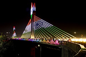
Durgam Cheruvu Bridge
Extradosed bridge in India
Distance: Approx. 2649 meters
Latitude and longitude: 17.4317,78.39
The Durgam Cheruvu Cable Bridge is an extradosed bridge in Hyderabad, Telangana, India. The bridge is located near Inorbit Mall at Madhapur. The bridge connects Jubilee Hills with Financial District and eases traffic congestion to Madhapur across Durgam Cheruvu.
Weather in this IP's area
clear sky
19 Celsius
19 Celsius
19 Celsius
19 Celsius
1015 hPa
66 %
1015 hPa
947 hPa
10000 meters
1.3 m/s
1.75 m/s
74 degree
06:18:12
17:42:24