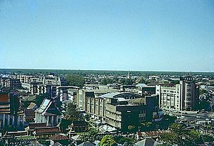
Country:
 Thailand
Region:
City:
Latitude and Longitude:
Time Zone:
Postal Code:
IP information under different IP Channel
ip-api
Country
Region
City
ASN
Time Zone
ISP
Blacklist
Proxy
Latitude
Longitude
Postal
Route
IPinfo
Country
Region
City
ASN
Time Zone
ISP
Blacklist
Proxy
Latitude
Longitude
Postal
Route
MaxMind
Country
Region
City
ASN
Time Zone
ISP
Blacklist
Proxy
Latitude
Longitude
Postal
Route
Luminati
Country
 US
USASN
Time Zone
America/Chicago
ISP
Kaopu Cloud HK Limited
Latitude
Longitude
Postal
db-ip
Country
Region
City
ASN
Time Zone
ISP
Blacklist
Proxy
Latitude
Longitude
Postal
Route
ipdata
Country
Region
City
ASN
Time Zone
ISP
Blacklist
Proxy
Latitude
Longitude
Postal
Route
Popular places and events near this IP address

Democracy Monument
Public monument in Bangkok, Thailand
Distance: Approx. 54 meters
Latitude and longitude: 13.75666667,100.50166667
The Democracy Monument (Thai: อนุสาวรีย์ประชาธิปไตย, romanized: Anusawari Prachathipatai) is a public monument in the city center of Bangkok, capital of Thailand. It occupies a traffic circle on the wide east–west Ratchadamnoen Avenue, at the intersection of Dinso Road. The monument is roughly halfway between Sanam Luang, the former royal cremation ground in front of Wat Phra Kaew, and the temple of the Golden Mount (Phu Kao Thong).

Wat Ratchanatdaram
Distance: Approx. 343 meters
Latitude and longitude: 13.75472222,100.50472222
Wat Ratchanatdaram (Thai: วัดราชนัดดาราม, pronounced [wát râːt.t͡ɕʰā.nát.dāːrāːm]) is a Buddhist temple (wat) located at the intersection between Ratchadamnoen Klang and Maha Chai Road, in Phra Nakhon district, Bangkok. Meaning Temple of the Royal Niece, the temple was built to the order of King Nangklao (Rama III) for his granddaughter, Princess Somanass Waddhanawathy in 1846. It is popularly known as Loha Prasat, literally meaning the iron palace.
Mahamakut Buddhist University
Public Buddhist university in Thailand
Distance: Approx. 326 meters
Latitude and longitude: 13.75916667,100.50138889
Mahamakut Buddhist University or MBU (Thai: มหาวิทยาลัยมหามกุฏราชวิทยาลัย; RTGS: Maha Makutta Ratcha Witthayalai) is one of the two public Buddhist universities in Thailand.
Queen Sirikit Gallery
Art museum in Bangkok, Thailand
Distance: Approx. 329 meters
Latitude and longitude: 13.756485,100.505037
Queen Sirikit Gallery or Queens Gallery (Thai: หอศิลป์สมเด็จพระนางเจ้าสิริกิติ์ พระบรมราชินีนาถ) is an art museum in Bangkok, Thailand. The gallery was established in 2003 after a request by Queen Sirikit of Thailand. She named the exhibition center "The Queen Sirikit Arts Exhibition Center" in Thai, and "The Queen's Gallery" in English.

Ratchadamnoen Avenue
Historic road in the districts of Phra Nakhon and Dusit in Bangkok, Thailand
Distance: Approx. 195 meters
Latitude and longitude: 13.7571,100.5004
Ratchadamnoen Avenue (Thai: ถนนราชดำเนิน, RTGS: Thanon Ratchadamnoen, pronounced [tʰā.nǒn râːt.t͡ɕʰā.dām.nɤ̄ːn], also spelled Rajdamnern) is a historic road in the Phra Nakhon and Pom Prap Sattru Phai with Dusit Districts of Bangkok, Thailand. Ratchadamnoen Avenue may be the most politically charged thoroughfare in the capital, as its history captures the ebb and flow of Thai ideological struggles over Thai governance in the 20th and 21st centuries.

Wat Mahannapharam
Buddhist temple in Bangkok, Thailand
Distance: Approx. 337 meters
Latitude and longitude: 13.754736,100.499328
Wat Mahannapharam Worawihan or Wat Mahan, commonly called Wat Mahanop (Thai: วัดมหรรณพ), is a Buddhist temple in Bangkok, Thailand. The first state school for general public in Thailand was established at the temple in 1884.

Saphan Wan Chat
Bridge in Bangkok, Thailand
Distance: Approx. 348 meters
Latitude and longitude: 13.75938889,100.50248333
Chaloem Wat Chat Bridge (Thai: สะพานเฉลิมวันชาติ, RTGS: Saphan Chaloem Wan Chat, pronounced [sā.pʰāːn t͡ɕʰā.lɤ̌ːm wān t͡ɕʰâːt]; lit. 'national day celebration bridge'; sometimes shortened to Saphan Wan Chat) is a bridge and four-way intersection in the area of Bang Lamphu, Bowon Niwet and Ban Phan Thom sub-districts, Phra Nakhon district, Bangkok. It's not far from Khao San and Rambuttri roads. Chaloem Wan Chat Bridge is a bridge across Khlong Rop Krung (around the city canal) or popularly known as Khlong Bang Lamphu.

Khok Wua
Crossroads on Rattanakosin Island, Bangkok, Thailand
Distance: Approx. 347 meters
Latitude and longitude: 13.75726389,100.49894444
Khok Wua (Thai: คอกวัว, pronounced [kʰɔ̂ːk wūa̯]) is an intersection in Bangkok. It is a four-way crossroads of Ratchadamnoen (section middle Ratchadamnoen) and Tanao roads in area of Bowon Niwet and Talat Yot sub-districts, Phra Nakhon district within Rattanakosin Island. The term Khok Wua means "cattle stable" due to the function of this area in the reign of King Nangklao (Rama III), when it was a pasture and grove wood with Hindus cow stables in order to send cow's milk to the nearby Grand Palace.

Tanao Road
Road in Phra Nakhon District, Bangkok
Distance: Approx. 331 meters
Latitude and longitude: 13.75563611,100.49901389
Tanao Road (Thai: ถนนตะนาว, RTGS: Thanon Tanao, pronounced [tʰā.nǒn tā.nāːw]) is a road in Phra Nakhon District, Bangkok. Starting from Bamrung Mueang Road at Si Kak Sao Chingcha straight to the north, it is also a boundary line between the San Chao Pho Suea and Sao Chingcha Subdistricts, then spans the Khlong Lot into the area of Bowon Niwet Subdistrict, then cut across Ratchadamnoen Avenue at Khok Wua Intersection, where it forms a dividing line between the Bowon Niwet and Talat Yot Subdistricts, as far as bend to the roundabout where Sip Sam Hang, Tani, Rambuttri, and Bowon Niwet Roads converge in Bang Lamphu area near Khao San Road. Originally, Tanao Road was a northern phase of Fueang Nakhon Road, which King Chulalongkorn (Rama VI) to be built in the year 1863–64.
Sala Chaloem Thai
Theatre in Bangkok, Thailand
Distance: Approx. 299 meters
Latitude and longitude: 13.7556843,100.5046892
Sala Chaloem Thai (Thai: ศาลาเฉลิมไทย, pronounced [sǎː.lāː t͡ɕʰā.lɤ̌ːm tʰāj]), abbreviated as Chaloem Thai (เฉลิมไทย), was a former movie theatre in Bangkok, located at the corner of Ratchadamnoen Avenue and Mahachai Road near the Fort Mahakan, opposite what is now the Queen Sirikit Gallery. This movie theatre was built in the year 1940 in the era of Field Marshal Plaek Phibunsongkhram to be another national theatre in Thailand as well as Sala Chalermkrung Royal Theatre in Wang Burapha neighbourhood. The red building's distinctive post-modern architecture was designed to harmonize with the surrounding buildings on Ratchadamnoen Avenue.

Mahannop Road
Street in Bangkok, Thailand
Distance: Approx. 370 meters
Latitude and longitude: 13.753235,100.500678
Mahannop Road (Thai: ถนนมหรรณพ) is a soi (alley)-like road in Bangkok. This short road is abour 300 m (984.3 ft) long covers the entire distance in the Sao Chingcha subdistrict of Phra Nakhon district in the historic neighbourhood known as Rattanakosin Island. It starts off separated from the west side of Dinso road in the area of Bangkok City Hall and northwestward up till it meets Tanao road, where notable Chinese joss house dedicated to Xuandi, San Chaopho Suea is situated.
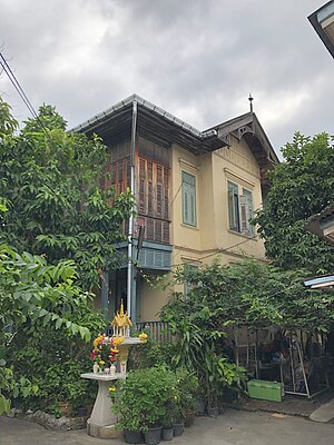
Baan Varnakovida
Restaurant
Distance: Approx. 271 meters
Latitude and longitude: 13.7564,100.4995
Baan Varnakovida (Thai: บ้านวรรณโกวิท, RTGS: Ban Wankowit) is a restaurant in Phra Nakhon, Bangkok, Thailand, specializing in pre-war Siamese cuisine. Owned by Apavinee Indaransi, Baan Varnakovida is housed in a Rama VI-era gingerbread house on Tanao Road. The 2-acre lot was bestowed on Indaransi's grandfather, Luang (หลวง) Krachang Varnakovida, for serving as a royal chancellor to King Rama VI. The restaurant is known for khao chae (Thai: ข้าวแช่), jasmine rice soaked in flower-infused water served with accompaniments.
Weather in this IP's area
overcast clouds
34 Celsius
41 Celsius
32 Celsius
34 Celsius
1006 hPa
57 %
1006 hPa
1005 hPa
10000 meters
5.5 m/s
9.6 m/s
258 degree
100 %
06:06:53
18:24:50