Country:
 South Korea
Region:
City:
Latitude and Longitude:
Time Zone:
Postal Code:
IP information under different IP Channel
ip-api
Country
Region
City
ASN
Time Zone
ISP
Blacklist
Proxy
Latitude
Longitude
Postal
Route
IPinfo
Country
Region
City
ASN
Time Zone
ISP
Blacklist
Proxy
Latitude
Longitude
Postal
Route
MaxMind
Country
Region
City
ASN
Time Zone
ISP
Blacklist
Proxy
Latitude
Longitude
Postal
Route
Luminati
Country
KRRegion
11
City
seoul
ASN
Time Zone
Asia/Seoul
ISP
JOYENT-INC
Latitude
Longitude
Postal
db-ip
Country
Region
City
ASN
Time Zone
ISP
Blacklist
Proxy
Latitude
Longitude
Postal
Route
ipdata
Country
Region
City
ASN
Time Zone
ISP
Blacklist
Proxy
Latitude
Longitude
Postal
Route
Popular places and events near this IP address

Seoul World Cup Stadium
Football stadium in Seoul, South Korea
Distance: Approx. 216 meters
Latitude and longitude: 37.56822222,126.89736111
The Seoul World Cup Stadium (Korean: 서울월드컵경기장), also known as Sangam Stadium, is a stadium used mostly for association football matches. The venue is located in 240, World Cup-ro, Mapo-gu, Seoul, South Korea. It was built for the 2002 FIFA World Cup and opened on November 10, 2001.

Mapo District
Autonomous district in Seoul, South Korea
Distance: Approx. 897 meters
Latitude and longitude: 37.5638,126.9084
Mapo District (Korean: 마포구; RR: Mapo-gu) is one of the 25 districts of Seoul, South Korea. Mapo has a population of 381,330 (2015) and has a geographic area of 23.87 km2 (9.22 sq mi), and is divided into 24 dong (administrative neighborhoods). Mapo is located in western Seoul on the northern bank of the Han River, bordering the Gyeonggi Province city of Goyang to the northwest, and the Seoul city districts of Gangseo to the west, Yeongdeungpo to the south, Yongsan to the southeast, Jung to the east, and Seodaemun and Eunpyeong to the north.

World Cup Stadium station (Seoul)
Station of the Seoul Metropolitan Subway
Distance: Approx. 189 meters
Latitude and longitude: 37.56972222,126.89916667
The World Cup Stadium Station is a metropolitan subway station in Seoul, Korea. The station was built to facilitate access to the Seoul World Cup Stadium for 2002 FIFA World Cup. The station has a very specific design with a main entrance reminiscent of a Greek amphitheater, between Exits 2 and 3.

Mapo-gu Office station
Distance: Approx. 550 meters
Latitude and longitude: 37.56388889,126.90305556
Mapo-gu Office Station is a Seoul Metropolitan Subway station near the Mapo district office in Seoul, opened in December 2000.

Bukgajwa-dong
Place in South Korea
Distance: Approx. 1423 meters
Latitude and longitude: 37.578,126.91
Bukgajwa-dong is a dong (neighborhood) of Seodaemun District, Seoul, South Korea. Seoul Metropolitan City Tangible Cultural Heritage Number 41, Hwasangunsindobi (Prince Hwasangun's tomb monument), is located here.
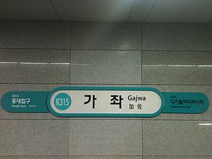
Gajwa station
Train station in Seoul, South Korea
Distance: Approx. 1365 meters
Latitude and longitude: 37.56865556,126.91525
Gajwa Station is a station on the Gyeongui–Jungang Line in Seoul, South Korea.

Digital Media City station
Train station in South Korea
Distance: Approx. 949 meters
Latitude and longitude: 37.57654,126.90132
Digital Media City Station (Korean: 디지털미디어시티역) is a railway station on Seoul Subway Line 6, AREX and the Gyeongui–Jungang Line. The former names of this station were Multimedia City Station (멀티미디어시티역) for the AREX station and Susaek (수색) for the Line 6.
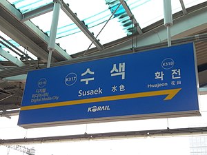
Susaek station
Station of the Seoul Metropolitan Subway
Distance: Approx. 1606 meters
Latitude and longitude: 37.58176111,126.89394722
Susaek Station is a station on the Gyeongui–Jungang Line. It is also the former name of Digital Media City Station on Line 6 of the Seoul Subway. Mugunghwa-ho and Saemaeul-ho trains that operate up to Seoul or Yongsan Stations are serviced at the Susaek Train Depot behind this station.

Seoul Lite
Proposed skyscraper in Seoul, South Korea
Distance: Approx. 1236 meters
Latitude and longitude: 37.574575,126.88841944
The Digital Media City Landmark Building (Korean: 디지털 미디어 시티 랜드마크 빌딩) or DMC Landmark Building, also known as Seoul Lite or Light Tower, was a 133-floor, 640 m (2,100 ft) supertall skyscraper proposed for construction in Digital Media City, Seoul, South Korea. It was slated to become the third-tallest building in the world when completed, after Burj Khalifa and Pingan International Finance Centre. It would have been the tallest building in Korea.
Digital Media City
Central business district
Distance: Approx. 1328 meters
Latitude and longitude: 37.57699722,126.88977222
Digital Media City (DMC; Korean: 디지털미디어시티) is a high-tech complex for digital technologies, housing ubiquitous networked offices, apartments, exhibitions, conference halls, television network headquarters and cultural centers in Seoul, South Korea. It is located at 366, Worldcupbuk-ro, Mapo District, Seoul. It was constructed in 2006 across 570,000 m2 (6,100,000 sq ft) and approximately 1.7 times the size of the Canary Wharf development in London, United Kingdom.

Oil Tank Culture Park
Ecological Park in Seoul, South Korea
Distance: Approx. 583 meters
Latitude and longitude: 37.57083333,126.89416667
The Oil Tank Culture Park (Korean: 문화비축기지; Hanja: 文化備蓄基地) is a renovated public park located in Mapo, Seoul, South Korea.
The Millennium Gate
Unbuilt structure in Seoul, South Korea
Distance: Approx. 1259 meters
Latitude and longitude: 37.5675,126.88555556
The Millennium Gate (Korean: 천년의 문), sometimes called Seoul Ring, was envisioned in 2000 as the world's first mega-sized ring-shaped architectural structure. It was planned to be erected along the Han River in Sangam-dong, Seoul, in conjunction with the new millennium (Millennium), and the 2002 Korea-Japan FIFA World Cup (2002 FIFA World Cup).
Weather in this IP's area
broken clouds
19 Celsius
19 Celsius
18 Celsius
19 Celsius
1022 hPa
72 %
1022 hPa
1020 hPa
10000 meters
5.14 m/s
10 degree
75 %
06:44:07
17:50:18