Country:
Region:
City:
Latitude and Longitude:
Time Zone:
Postal Code:
IP information under different IP Channel
ip-api
Country
Region
City
ASN
Time Zone
ISP
Blacklist
Proxy
Latitude
Longitude
Postal
Route
Luminati
Country
ASN
Time Zone
America/Chicago
ISP
COUNTRY-INSURANCE
Latitude
Longitude
Postal
IPinfo
Country
Region
City
ASN
Time Zone
ISP
Blacklist
Proxy
Latitude
Longitude
Postal
Route
db-ip
Country
Region
City
ASN
Time Zone
ISP
Blacklist
Proxy
Latitude
Longitude
Postal
Route
ipdata
Country
Region
City
ASN
Time Zone
ISP
Blacklist
Proxy
Latitude
Longitude
Postal
Route
Popular places and events near this IP address

Central Illinois Regional Airport
Commercial airport near Bloomington, Illinois, USA
Distance: Approx. 3518 meters
Latitude and longitude: 40.47722222,-88.91583333
Central Illinois Regional Airport at Bloomington–Normal (IATA: BMI, ICAO: KBMI, FAA LID: BMI) is a public airport in McLean County, Illinois, three miles east of Bloomington and southeast of Normal. Owned by the Bloomington–Normal Airport Authority, it is also known as Central Illinois Regional Airport (CIRA). The National Plan of Integrated Airport Systems for 2023–2027 categorized it as a primary commercial service airport.
Bloomington High School (Bloomington, Illinois)
Public school in Bloomington, Illinois, United States
Distance: Approx. 3349 meters
Latitude and longitude: 40.4866,-88.9741
Bloomington High School (BHS) is a public secondary school in Bloomington, Illinois, and is part of Bloomington School District 87.
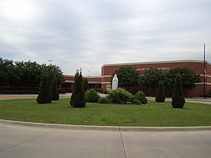
Central Catholic High School (Bloomington, Illinois)
School in Bloomington, Illinois, United States
Distance: Approx. 1845 meters
Latitude and longitude: 40.49305556,-88.92277778
Central Catholic High School (CCHS or Central Catholic) is a private co-educational Catholic high school in Bloomington, Illinois, United States. It serves approximately 320 students in the Bloomington-Normal area. CCHS is one of seven Catholic high schools in the Roman Catholic Diocese of Peoria and the only Catholic high school in McLean County.

Douglas R4D-3 N763A
United States historic place
Distance: Approx. 2089 meters
Latitude and longitude: 40.48527778,-88.93111111
Former United States Army Air Force aircraft serial number 41-20124 is a World War II era fully restored Douglas DC-3, owned by a private party and based at Marathon Key, FL. Civil registered as N763A the aircraft has also been operated by the United States Navy with the designation R4D-3 and serial number 05078. The aircraft has been listed on the National Register of Historic Places since August 1, 1996.
Illinois Shakespeare Festival
Distance: Approx. 2300 meters
Latitude and longitude: 40.494,-88.9653
The Illinois Shakespeare Festival (ISF) is held in Bloomington, Illinois, United States at Ewing Theatre and in Normal, Illinois, United States at the Center for Performing Arts Theatre at Illinois State University. The Festival began in 1978 and celebrated its 45th season in 2023. The Festival has traditionally presented three plays.

Barnes, Illinois
Unincorporated community in Illinois, United States
Distance: Approx. 3296 meters
Latitude and longitude: 40.50277778,-88.90166667
Barnes is an unincorporated community in McLean County, Illinois.
Eastland Mall (Bloomington, Illinois)
Shopping mall in Illinois, United States
Distance: Approx. 2235 meters
Latitude and longitude: 40.486126,-88.955698
Eastland Mall is a shopping mall in Bloomington, Illinois. It opened in 1967 and has expanded several times in its history. It features more than 90 stores and a food court.

The Shoppes at College Hills
Shopping mall in Illinois, United States
Distance: Approx. 1401 meters
Latitude and longitude: 40.5066,-88.9563
The Shoppes at College Hills is a lifestyle center retail complex located in the city of Normal, Illinois, USA. It is one of two major shopping centers in the Bloomington-Normal area (the other being Eastland Mall). The complex was built in 1980 as a small enclosed shopping mall called College Hills Mall, and was demolished and rebuilt in 2005 as an outdoor center. Anchor stores include Hobby Lobby, Target, Crunch Fitness, and Von Maur.
WXRJ-LP
Radio station in Bloomington, Illinois
Distance: Approx. 1040 meters
Latitude and longitude: 40.50055556,-88.92861111
WXRJ-LP (94.9 FM, "Real Radio") is a radio station broadcasting an urban adult contemporary music format. Licensed to Bloomington, Illinois, United States, the station serves the Bloomington area. The station is currently owned by Black Business Alliance, Inc.
Moses Montefiore Congregation
Reform synagogue in Bloomington, Illinois, United States
Distance: Approx. 2515 meters
Latitude and longitude: 40.49138889,-88.96638889
The Moses Montefiore Congregation is a Reform Jewish congregation and synagogue located at 102 Robinhood Lane in Bloomington, Illinois, in the United States.

OSF St. Joseph Medical Center
Hospital in Illinois, United States
Distance: Approx. 2565 meters
Latitude and longitude: 40.4828,-88.9561
OSF St. Joseph Medical Center is a 149-bed Level II trauma center hospital complex in Bloomington, Illinois, USA, and is part of the OSF Healthcare System. St.
Prairie Aviation Museum
Aviation museum in Bloomington, Illinois
Distance: Approx. 2042 meters
Latitude and longitude: 40.488,-88.926
The Prairie Aviation Museum is an aviation museum located at Central Illinois Regional Airport in Bloomington, Illinois.
Weather in this IP's area
broken clouds
15 Celsius
15 Celsius
14 Celsius
16 Celsius
1008 hPa
98 %
1008 hPa
980 hPa
10000 meters
5.14 m/s
200 degree
75 %
06:30:57
16:47:47
