148.51.208.35 - IP Lookup: Free IP Address Lookup, Postal Code Lookup, IP Location Lookup, IP ASN, Public IP
Country:
Region:
City:
Location:
Time Zone:
Postal Code:
IP information under different IP Channel
ip-api
Country
Region
City
ASN
Time Zone
ISP
Blacklist
Proxy
Latitude
Longitude
Postal
Route
Luminati
Country
ASN
Time Zone
America/Chicago
ISP
IMDC-AS12025
Latitude
Longitude
Postal
IPinfo
Country
Region
City
ASN
Time Zone
ISP
Blacklist
Proxy
Latitude
Longitude
Postal
Route
IP2Location
148.51.208.35Country
Region
new york
City
new york city
Time Zone
America/New_York
ISP
Language
User-Agent
Latitude
Longitude
Postal
db-ip
Country
Region
City
ASN
Time Zone
ISP
Blacklist
Proxy
Latitude
Longitude
Postal
Route
ipdata
Country
Region
City
ASN
Time Zone
ISP
Blacklist
Proxy
Latitude
Longitude
Postal
Route
Popular places and events near this IP address

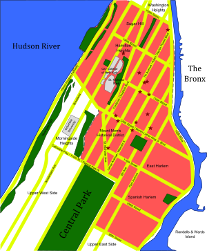
East Harlem
Neighborhood of Manhattan in New York City
Distance: Approx. 398 meters
Latitude and longitude: 40.79861111,-73.94166667
East Harlem, also known as Spanish Harlem, Finnish Harlem or El Barrio, is a neighborhood of Upper Manhattan in New York City, north of the Upper East Side and bounded by 96th Street to the south, Fifth Avenue to the west, and the East and Harlem Rivers to the east and north. Despite its name, it is generally not considered to be a part of Harlem proper, but it is one of the neighborhoods included in Greater Harlem. The neighborhood has one of the largest Hispanic communities in New York City, mostly Puerto Ricans, as well as Dominicans, Cubans, and Mexicans.

110th Street station (IRT Lexington Avenue Line)
New York City Subway station in Manhattan
Distance: Approx. 348 meters
Latitude and longitude: 40.794773,-73.944426
The 110th Street station is a local station on the IRT Lexington Avenue Line of the New York City Subway. Located in East Harlem at the intersection of 110th Street and Lexington Avenue, it is served by the 6 train at all times, the <6> train during weekdays in the peak direction, and the 4 train during late nights. This station was constructed as part of the Dual Contracts by the Interborough Rapid Transit Company and opened in 1918.

116th Street station (IRT Lexington Avenue Line)
New York City Subway station in Manhattan
Distance: Approx. 369 meters
Latitude and longitude: 40.798607,-73.942022
The 116th Street station is a local station on the IRT Lexington Avenue Line of the New York City Subway. Located at the intersection of Lexington Avenue and 116th Street in East Harlem, it is served by the 6 train at all times, the <6> train during weekdays in the peak direction, and the 4 train during late nights. This station was constructed as part of the Dual Contracts by the Interborough Rapid Transit Company and opened in 1918.

Upper Manhattan
Northern part of Manhattan, New York City
Distance: Approx. 245 meters
Latitude and longitude: 40.797,-73.949
Upper Manhattan is the northern section of the New York City borough of Manhattan. Its southern boundary has been variously defined, but some of the most common usages are 96th Street, 110th Street (the northern boundary of Central Park), 125th Street, or 155th Street. The term Uptown can refer to Upper Manhattan, but is often used more generally for neighborhoods above 59th Street; in the broader definition, Uptown encompasses Upper Manhattan.

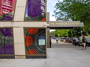
The Africa Center
Museum in Manhattan, New York
Distance: Approx. 284 meters
Latitude and longitude: 40.79638889,-73.94916667
The Africa Center, formerly known as the Museum for African Art and before that as the Center for African Art, is a museum located at Fifth Avenue and 110th Street in East Harlem, Manhattan, New York City, near the northern end of Fifth Avenue's Museum Mile. Founded in 1984, the museum is "dedicated to increasing public understanding and appreciation of African art and culture." The Museum is also well known for its public education programs that help raise awareness of African culture, and also operates a unique store selling authentic handmade African crafts. The Museum has organized nearly 60 critically acclaimed exhibitions and traveled these to almost 140 venues nationally and internationally, including 15 other countries.

La Marqueta
Markets in New York City, US
Distance: Approx. 153 meters
Latitude and longitude: 40.79770833,-73.94439444
La Marqueta is a marketplace under the elevated Metro North railway tracks between 111th Street and 116th Street on Park Avenue in East Harlem in Manhattan, New York City. Its official address is 1590 Park Avenue. In its heyday in the 1950s and 1960s, over 500 vendors operated out of La Marqueta, and it was an important social and economic venue for Hispanic New York.
Clinton Houses
Public housing development in Manhattan, New York
Distance: Approx. 307 meters
Latitude and longitude: 40.7973,-73.94258
Governor DeWitt Clinton Houses, also known as DeWitt Clinton Houses or Clinton Houses, is a public housing development built and maintained by the New York City Housing Authority (NYCHA) in the Spanish Harlem neighborhood of Manhattan. Clinton Houses is composed of six buildings, resting on a non-continuous campus with an area of 5.6 acres (23,000 m2). Five of those (I-V) are 18 stories high, and another (VI) is nine stories high.

Duke Ellington Circle
Traffic circle in Manhattan, New York
Distance: Approx. 268 meters
Latitude and longitude: 40.796872,-73.949236
Duke Ellington Circle is a traffic circle located at the northeast corner of Central Park at the intersection of Fifth Avenue and 110th Street in Harlem, Manhattan, New York City. The traffic circle is named for the jazz musician Duke Ellington.
Lincoln Correctional Facility
Minimum-security state prison for men located in New York, US
Distance: Approx. 371 meters
Latitude and longitude: 40.7977,-73.9506
Lincoln Correctional Facility was a United States minimum-security men's prison located at 31–33 West 110th Street in Manhattan, New York, facing the north side of Central Park. It was used primarily as a work-release center for drug offenders; however, around 5% of the roughly 275 inmates it housed were white collar criminals, sometimes for work release.

2014 East Harlem gas explosion
Explosion caused by gas leak
Distance: Approx. 338 meters
Latitude and longitude: 40.79972222,-73.94333333
On March 12, 2014, an explosion occurred at 9:31 a.m. in the East Harlem neighborhood of Manhattan in New York City, United States. The explosion leveled two apartment buildings located just north of 116th Street at 1644 and 1646 Park Avenue, killing eight people, injuring at least 70 others, and displacing 100 families.

110th Street station (New York Central Railroad)
Closed train station in Manhattan, New York
Distance: Approx. 234 meters
Latitude and longitude: 40.795502,-73.946057
The 110th Street station was a station located on the Metro-North Railroad's Park Avenue Viaduct in East Harlem, Manhattan, New York City. The station was built by the New York Central & Hudson River Railroad as part of an agreement with the New York City government. It was located at Park Avenue and 110th Street.

Duke Ellington Memorial
Memorial in Manhattan, New York, U.S.
Distance: Approx. 277 meters
Latitude and longitude: 40.79691667,-73.94936111
The Duke Ellington Memorial by Robert Graham is installed at Duke Ellington Circle in Manhattan, New York City, New York. The monument depicts Duke Ellington at a piano, supported by three columns depicting three caryatids each, known as his nine muses. It was cast in 1997 and dedicated on July 1 of that year.
Weather in this IP's area
few clouds
-1 Celsius
-8 Celsius
-2 Celsius
-0 Celsius
1009 hPa
55 %
1009 hPa
1009 hPa
10000 meters
7.72 m/s
12.35 m/s
310 degree
20 %
