Country:
 Great Britain
Region:
City:
Latitude and Longitude:
Time Zone:
Postal Code:
IP information under different IP Channel
ip-api
Country
Region
City
ASN
Time Zone
ISP
Blacklist
Proxy
Latitude
Longitude
Postal
Route
IPinfo
Country
Region
City
ASN
Time Zone
ISP
Blacklist
Proxy
Latitude
Longitude
Postal
Route
MaxMind
Country
Region
City
ASN
Time Zone
ISP
Blacklist
Proxy
Latitude
Longitude
Postal
Route
Luminati
Country
GBASN
Time Zone
Europe/London
ISP
British Telecommunications PLC
Latitude
Longitude
Postal
db-ip
Country
Region
City
ASN
Time Zone
ISP
Blacklist
Proxy
Latitude
Longitude
Postal
Route
ipdata
Country
Region
City
ASN
Time Zone
ISP
Blacklist
Proxy
Latitude
Longitude
Postal
Route
Popular places and events near this IP address
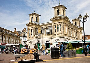
Kingston upon Thames
Town in South West London
Distance: Approx. 237 meters
Latitude and longitude: 51.4103,-0.2995
Kingston upon Thames, colloquially known as Kingston, is a town in the Royal Borough of Kingston upon Thames, south-west London, England. It is situated on the River Thames, 10 miles (16 km) south-west of Charing Cross. It is an ancient market town, notable as the place where some Saxon kings were crowned.

Nipper
Canine mascot of HMV, RCA, and the Victor Talking Machine Company (1884–1895)
Distance: Approx. 181 meters
Latitude and longitude: 51.41099,-0.302226
Nipper (1884 – September 1895), also known as the RCA Victor dog, was a dog from Bristol, UK. Bred as a terrier mix, he served as the model for a 1898 painting by British painter Francis Barraud titled His Master's Voice. This image has become one of the world's best known trademarks, the famous dog-and-gramophone pairing that has been used by several record companies and their associated company brands, including Berliner Gramophone and its various affiliates and successors, among them Berliner's German subsidiary Deutsche Grammophon; Berliner's American successor the Victor Talking Machine Co. (later known as RCA Victor and then RCA Records); Zonophone; Berliner's (and later Victor's) British affiliate the Gramophone Co.
Tiffin School
Boys' grammar school in London
Distance: Approx. 338 meters
Latitude and longitude: 51.4115,-0.296
Tiffin School is a boys' grammar school in Kingston upon Thames, England. It has specialist status in both the performing arts and languages. The school moved from voluntary aided status to become an Academy School on 1 July 2011.

Kingston railway station (England)
National Rail station in London, England
Distance: Approx. 57 meters
Latitude and longitude: 51.4127,-0.3012
Kingston railway station is in Kingston upon Thames in south-west London. It is 12 miles 9 chains (19.5 km) down the line from London Waterloo. The station and all trains serving it are operated by South Western Railway.

Municipal Borough of Kingston-upon-Thames
Distance: Approx. 240 meters
Latitude and longitude: 51.4103,-0.2994
Kingston-upon-Thames (spelt with hyphens) was a local government district in north east Surrey, England from 1835 to 1965 around the town now known as Kingston upon Thames. It was alternatively known as Kingston on Thames (spelt with or without hyphens). It was a municipal borough and also held the rarer status of Royal borough.

Hundred of Kingston
Distance: Approx. 58 meters
Latitude and longitude: 51.412,-0.3
The Hundred of Kingston or Kingston Hundred was an ancient hundred in the north east of the county of Surrey, England. Its area has been mostly absorbed by the growth of London; with its name currently referring to both the suburban town of Kingston upon Thames and the larger Royal Borough of Kingston upon Thames. Its former area now corresponds to that borough and part of the London Borough of Richmond upon Thames in Greater London and part of the borough of Elmbridge in Surrey.

Outside the Box Comedy Club
Comedy club in London, England
Distance: Approx. 267 meters
Latitude and longitude: 51.41055556,-0.29805556
Outside the Box is a comedy club located in the backroom of The Fighting Cocks pub in Kingston-upon-Thames. It was opened in November 2006 by comedian Maff Brown. Three months after attending a comedy course in the summer of 2006, Brown established the club in order to test his own material before taking it around the comedy circuit.

Kingston Museum
History museum in England
Distance: Approx. 302 meters
Latitude and longitude: 51.4096,-0.3003
Kingston Museum is an accredited museum in Kingston upon Thames, southwest London, England. The Scottish-American philanthropist Andrew Carnegie funded the building of the museum, which adjoins Kingston Library. The museum runs a programme of temporary exhibitions and events; entry is free of charge.

Kingston upon Thames (parish)
Distance: Approx. 58 meters
Latitude and longitude: 51.412,-0.3
Kingston upon Thames was an ancient parish in the county of Surrey, England. By 1839 it contained these chapelries, curacies or ecclesiastical parishes which eventually became civil parishes in their own right: It follows from the above list of chapelries and the hamlet of Hook, frequently listed in the medieval age that, well before the Conquest, the ancient parish was the Kingston hundred (of Surrey). There soon was a southern exception to this.

Bentall Centre, Kingston upon Thames
Shopping mall in London, England
Distance: Approx. 274 meters
Latitude and longitude: 51.412,-0.3046
The Bentall Centre is a large shopping centre in Kingston upon Thames, Greater London, England, which opened in 1992. It has been built in the retail space of Bentalls department store, first established on the site in 1867. Bentalls, now part of the Fenwick group, retains a large premium department store in the development.

The Fighting Cocks
Music venue in Kingston upon Thames, London
Distance: Approx. 237 meters
Latitude and longitude: 51.4103,-0.2995
The Fighting Cocks is a music venue built prior to 1890 active since the 1930s and located in Kingston upon Thames, the administrative centre of the Royal Borough of Kingston, southwest London, England. It specializes in rock and roll, punk, metal, folk, ska, alternative, rockabilly, electro, comedy, and cabaret performances. It was conspicuous for hosting touring jazz acts in the late 1930s and in the 1940s.

Eden Walk
Shopping centre in London, England
Distance: Approx. 274 meters
Latitude and longitude: 51.412,-0.3046
Eden Walk is an open precinct shopping centre in Kingston upon Thames, Greater London, England. It opened in 1968, predating The Bentall Centre by two decades.
Weather in this IP's area
clear sky
16 Celsius
15 Celsius
14 Celsius
17 Celsius
1013 hPa
84 %
1013 hPa
1012 hPa
10000 meters
2.24 m/s
3.13 m/s
225 degree
07:30:28
18:01:47