Country:
 Mexico
Region:
City:
Latitude and Longitude:
Time Zone:
Postal Code:
IP information under different IP Channel
ip-api
Country
Region
City
ASN
Time Zone
ISP
Blacklist
Proxy
Latitude
Longitude
Postal
Route
IPinfo
Country
Region
City
ASN
Time Zone
ISP
Blacklist
Proxy
Latitude
Longitude
Postal
Route
MaxMind
Country
Region
City
ASN
Time Zone
ISP
Blacklist
Proxy
Latitude
Longitude
Postal
Route
Luminati
Country
MXRegion
yuc
City
merida
ASN
Time Zone
America/Merida
ISP
Alestra, S. de R.L. de C.V.
Latitude
Longitude
Postal
db-ip
Country
Region
City
ASN
Time Zone
ISP
Blacklist
Proxy
Latitude
Longitude
Postal
Route
ipdata
Country
Region
City
ASN
Time Zone
ISP
Blacklist
Proxy
Latitude
Longitude
Postal
Route
Popular places and events near this IP address

Mérida International Airport
Airport in Mérida, Yucatán, Mexico
Distance: Approx. 5951 meters
Latitude and longitude: 20.93694444,-89.65777778
Mérida International Airport (Spanish: Aeropuerto Internacional de Mérida), officially Aeropuerto Internacional Manuel Crescencio Rejón (Manuel Crescencio Rejón International Airport) (IATA: MID, ICAO: MMMD), is an international airport located in the Mexican city of Mérida. It serves as the primary international gateway to Mérida and the State of Yucatán, a popular tourist destination, offering flights to and from Mexico, the United States, Canada, Central America, and the Caribbean. The airport also accommodates facilities for the Mexican Airspace Navigation Services, and the Mexican Army, and supports various tourism, flight training, and general aviation activities.

Parque Kukulcán Alamo
Distance: Approx. 8422 meters
Latitude and longitude: 20.94121111,-89.59598333
Parque Kukulcán Alamo (Kukulcán Alamo Park) is a stadium located in the city of Mérida, Yucatán, Mexico. It is primarily used for baseball, and is the home field of the Leones de Yucatán (Yucatán Lions) Mexican League baseball team. It holds 14,917 people and was opened in 1982.
Hacienda Dzoyolá
Private Residence / Event Venue in Yucatán, Mexico
Distance: Approx. 6956 meters
Latitude and longitude: 20.90277778,-89.58527778
Hacienda Dzoyolá is located in the Mérida Municipality in the state of Yucatán in southeastern Mexico. It is one of the properties that arose during the nineteenth century henequen boom.

Cuxtal Ecological Reserve
Ecological Preservation Area in Yucatán, Mexico
Distance: Approx. 3687 meters
Latitude and longitude: 20.86055556,-89.62416667
The Cuxtal Ecological Reserve (IPA: [kuʃˈtal], from the Mayan language meaning "life") is located in the southern zone of Mérida Municipality, between 20° 47' and 20° 55' of north latitude and 89° 33 and 89° 40' of west longitude. The Reserve limits to the north with the city of Mérida, south with the commissariats of Yaxnic and Texán Cámara, east with the municipality of Kanasín and west with the commissariats of San José Tzal and Ticimul. It provides 50% of the water in the City of Mérida and is home to 168 bird species, most of them migratory, as well as plants, mammals, reptiles, invertebrates and amphibians.

Hacienda San Ignacio Tesip
Private Event Venue in Yucatán, Mexico
Distance: Approx. 5613 meters
Latitude and longitude: 20.84777778,-89.61166667
Hacienda San Ignacio Tesip is located in the Mérida Municipality in the state of Yucatán in southeastern Mexico. It is one of the properties that arose during the nineteenth century henequen boom. It is part of the Cuxtal Ecological Reserve which was set aside in 1993 to protect both the man-made and natural history of the reserve area of Mérida.
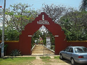
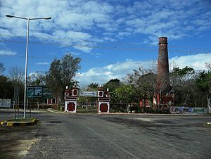
Hacienda San Antonio Tahdzibichén
Private Event Venue in Yucatán, Mexico
Distance: Approx. 5339 meters
Latitude and longitude: 20.885,-89.59777778
Hacienda San Antonio Tahdzibichén (also known as Tahdzibichén) is located in the Mérida Municipality in the state of Yucatán in southeastern Mexico. It is one of the properties that arose during the nineteenth century henequen boom. It is part of the Cuxtal Ecological Reserve which was set aside in 1993 to protect both the man-made and natural history of the reserve area of Mérida.

Hacienda San Pedro Chimay
Private Residence in Yucatán, Mexico
Distance: Approx. 7542 meters
Latitude and longitude: 20.86527778,-89.57944444
Hacienda San Pedro Chimay is located in the Mérida Municipality in the state of Yucatán in southeastern Mexico. It is one of the properties that arose during the nineteenth century henequen boom. It is part of the Cuxtal Ecological Reserve which was set aside in 1993 to protect both the man-made and natural history of the reserve area of Mérida.

Hacienda Santa Cruz Palomeque
Hotel in Yucatán, Mexico
Distance: Approx. 722 meters
Latitude and longitude: 20.87916667,-89.65361111
Hacienda Santa Cruz Palomeque is located in the Mérida Municipality in the state of Yucatán in southeastern Mexico. It is one of the properties that arose during the nineteenth century henequen boom. It is part of the Cuxtal Ecological Reserve which was set aside in 1993 to protect both the man-made and natural history of the reserve area of Mérida.
Hacienda Xmatkuil
Site of the Yucatán State Fair in Mexico
Distance: Approx. 3601 meters
Latitude and longitude: 20.86138889,-89.62444444
Hacienda Xmatkuil (Spanish pronunciation: [iʃmaðˈkwil]) is located in the Mérida Municipality in the state of Yucatán in southeastern Mexico. It is one of the properties that arose during the nineteenth century henequen boom. It is part of the Cuxtal Ecological Reserve, which was set aside in 1993 to protect both the artificial and natural history of the reserve area of Mérida.

Quintana Roo Municipality
Municipality in the Mexican state of Yucatán
Distance: Approx. 2523 meters
Latitude and longitude: 20.86861111,-89.63138889
Quintana Roo Municipality (Named after a patriot, Andrés Quintana Roo, from Mérida, Yucatán, who supported Mexican independence.) is a municipality in the Mexican state of Yucatán containing (139.24 km2) of land and located roughly 104 km east of the city of Mérida.
San José Tzal
Place in Yucatán, Mexico
Distance: Approx. 6788 meters
Latitude and longitude: 20.82416667,-89.66111111
San José Tzal is a town located in the Mérida Municipality, Yucatán in Mexico.
Korea–Mexico Friendship Hospital
Hospital in Mérida, Yucatán, Mexico
Distance: Approx. 2259 meters
Latitude and longitude: 20.9023,-89.6395
The Korea–Mexico Friendship Hospital (Spanish: Hospital de la Amistad Corea-México; Korean: 한·멕 우정병원) is a hospital in Mérida, Yucatán, Mexico. It first opened on July 6, 2005. It was established as part of commemorations for the 100th anniversary of Koreans arriving in Mexico.
Weather in this IP's area
moderate rain
28 Celsius
34 Celsius
28 Celsius
28 Celsius
1014 hPa
86 %
1014 hPa
1013 hPa
10000 meters
7.15 m/s
9.83 m/s
46 degree
37 %
05:55:04
17:31:53