148.236.18.94 - IP Lookup: Free IP Address Lookup, Postal Code Lookup, IP Location Lookup, IP ASN, Public IP
Country:
 Mexico
Region:
City:
Location:
Time Zone:
Postal Code:
ISP:
ASN:
language:
User-Agent:
Proxy IP:
Blacklist:
IP information under different IP Channel
ip-api
Country
Region
City
ASN
Time Zone
ISP
Blacklist
Proxy
Latitude
Longitude
Postal
Route
db-ip
Country
Region
City
ASN
Time Zone
ISP
Blacklist
Proxy
Latitude
Longitude
Postal
Route
IPinfo
Country
Region
City
ASN
Time Zone
ISP
Blacklist
Proxy
Latitude
Longitude
Postal
Route
IP2Location
148.236.18.94Country
mxRegion
tabasco
City
villahermosa
Time Zone
America/Mexico_City
ISP
Language
User-Agent
Latitude
Longitude
Postal
ipdata
Country
Region
City
ASN
Time Zone
ISP
Blacklist
Proxy
Latitude
Longitude
Postal
Route
Popular places and events near this IP address
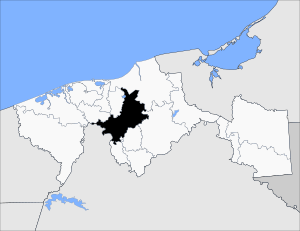
Tabasco
State of Mexico
Distance: Approx. 604 meters
Latitude and longitude: 17.98805556,-92.91944444
Tabasco, officially the Free and Sovereign State of Tabasco, is one of the 32 Federal Entities of Mexico. It is divided into 17 municipalities and its capital city is Villahermosa. It is the namesake of Tabasco sauce.

Second Battle of Tabasco
Distance: Approx. 1368 meters
Latitude and longitude: 17.98916667,-92.92805556
The Second Battle of Tabasco, also known as the Battle of Villahermosa, was fought in June 1847 during the Mexican–American War as part of the U.S. blockade of Mexican Gulf ports.: 339

First Battle of Tabasco
1846 Mexican–American War battle
Distance: Approx. 1368 meters
Latitude and longitude: 17.98916667,-92.92805556
The First Battle of Tabasco was fought during the Mexican–American War, in October 1846, in an attempt to capture cities along the Tabasco coast.: 117

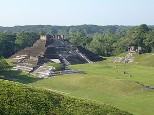
Villahermosa Mexico Temple
Distance: Approx. 2201 meters
Latitude and longitude: 17.981276,-92.937375
The Villahermosa Mexico Temple is the 85th operating temple of the Church of Jesus Christ of Latter-day Saints (LDS Church).
Centro Municipality, Tabasco
Municipality in the Mexican state of Tabasco
Distance: Approx. 1368 meters
Latitude and longitude: 17.98916667,-92.92805556
The Municipality of Centro is one of the 17 municipalities of the Mexican state of Tabasco. Its municipal seat is located in the city of Villahermosa. The municipality had a 2010 census population of 640,359 inhabitants, 353,577 (55.2%) of whom lived in its municipal seat, Villahermosa.

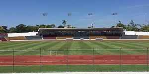
Estadio Centenario 27 de Febrero
Distance: Approx. 3001 meters
Latitude and longitude: 17.97666667,-92.94416667
The Parque de Béisbol Centenario del 27 de Febrero, also referred to as Estadio Centenario Orsan for sponsorship reasons, is a stadium in Villahermosa, Mexico. It is primarily used for baseball and serves as the home stadium for the Olmecas de Tabasco. The stadium has a capacity of 6,600 people and is named in honor of the Battle of San Juan Bautista, which was fought nearby.

Universidad Juárez Autónoma de Tabasco
PUblic university in n Villahermosa, Tabasco, Mexico
Distance: Approx. 2922 meters
Latitude and longitude: 18.00833333,-92.925
Universidad Juárez Autónoma de Tabasco (Juárez Autonomous University of Tabasco, also known as UJAT) is a public institution of higher learning located in Villahermosa, Tabasco, Mexico. The mission of the university is "to prepare professionals with broad and deep expertise in their area of study to fill the needs of Tabasco and the country at large." UJAT is the largest and most prominent university in the state of Tabasco. During the 2007-2008 academic year the university enrolled 35,271 students and had a teaching staff of over 2,000.
Televisión Tabasqueña
Public TV network of the Mexican state of Tabasco
Distance: Approx. 2438 meters
Latitude and longitude: 17.96861111,-92.93377778
Televisión Tabasqueña (TVT) is a state-owned public television network serving the Mexican state of Tabasco on three broadcast transmitters. The network is operated by CORAT, the Tabasco Radio and Television Commission, along with La Radio de Tabasco and Mega 94.9. TVT programming primarily consists of cultural and educational content.
Timeline of Villahermosa
Distance: Approx. 1368 meters
Latitude and longitude: 17.989167,-92.928056
The following is a timeline of the history of the city of Villahermosa in Centro Municipality, Tabasco state, Mexico.

Villahermosa Cathedral
Church in Villahermosa, Mexico
Distance: Approx. 1374 meters
Latitude and longitude: 17.9892,-92.9281
The Cathedral of the Lord (Spanish: Catedral del Señor de Villahermosa) Also Villahermosa Cathedral or Tabasco Cathedral Is the main Catholic cathedral of the city of Villahermosa, in Mexico, and the central church of the Diocese of Tabasco. The first church built in its present location dates back to 1776 known as the Church of the Lord of Esquipulas, named after because it was built in honor of the Lord of Esquipulas, a black Christ brought from the population of Esquipulas, Guatemala and that on March 18, 1774, was donated by the Bishop of Yucatán Don Diego de Peredo. On April 16, 1884, Bishop Agustín de Jesus Torres Hernández placed the first stone of the new Cathedral of Tabasco, however, it was not possible to finish its construction, so the Cathedral of Esquipulas continued to be the Cathedral of Tabasco until 1928 when it was closed due to the anti-religious campaign undertaken by then-state governor Tomás Garrido Canabal, which ordered the closure of churches and destruction of religious images throughout the state.
Estadio Olímpico de Villahermosa
Distance: Approx. 3158 meters
Latitude and longitude: 17.97611111,-92.94555556
The Estadio Olímpico de Villahermosa is a multi-use stadium located in Villahermosa, Tabasco, Mexico. It is currently used mostly for football matches and is the home stadium for Napoli Tabasco. The stadium has a capacity of 12,000 people.

Monumento a Andrés Sánchez Magallanes
Monument in Villahermosa, Tabasco
Distance: Approx. 3174 meters
Latitude and longitude: 17.99216667,-92.94519444
The Monumento a Andrés Sánchez Magallanes, colloquially known as La Chichona (lit. transl. The Busty Woman), is a memorial in Villahermosa, Tabasco. It was dedicated to Colonel Andrés Sánchez Magallanes, who commanded key battles for the expulsion of the French from Villahermosa during the Second French intervention in Mexico.
Weather in this IP's area
scattered clouds
21 Celsius
21 Celsius
21 Celsius
21 Celsius
1016 hPa
85 %
1016 hPa
1016 hPa
10000 meters
3.22 m/s
6.79 m/s
65 degree
32 %